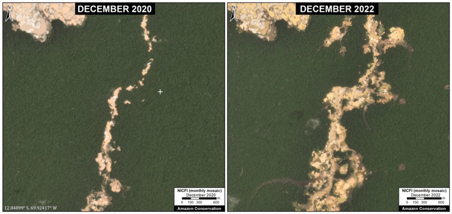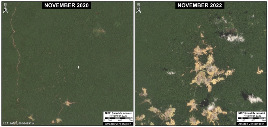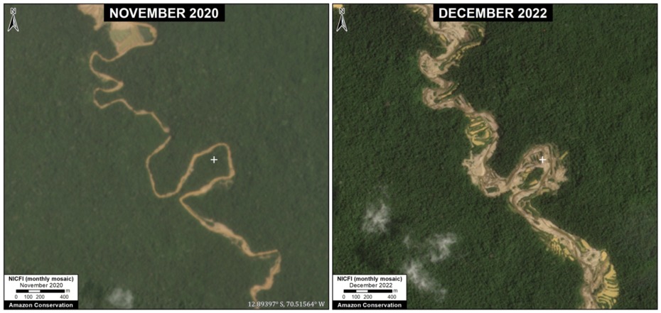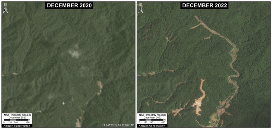
MAAP #208: Gold mining in the southern Peruvian Amazon, summary 2021-2024

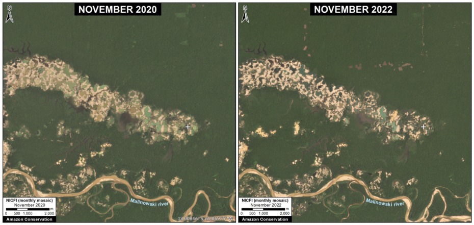
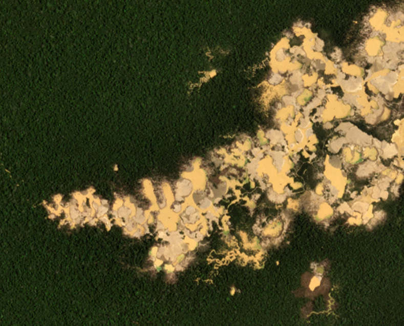
Figure 1. Recent expansion of illegal gold mining in the southern Peruvian Amazon. Data: Planet, NICFI

With the technical support of USAID (United States Agency for International Development) and Norad (Norwegian Agency for Development Cooperation),1 we have published a series of reports on the dynamic situation regarding gold mining in the southern Peruvian Amazon during recent years 2.

Illegal gold mining reached crisis levels between 2017 and 2018 in the area known as La Pampa (Madre de Dios region), eliminating thousands of hectares of primary forest in the buffer zone of the Tambopata National Reserve.

In early 2019, the Peruvian government implemented Operation Mercury, a multi-sectoral intervention against illegal mining, initially focusing on La Pampa. This operation was later replaced (in 2021) by the Restoration Plan, which included interventions in other critical mining areas of the Madre de Dios region in the southern Peruvian Amazon.

In this report, we offer a concise summary of the mining situation during the past three years (between January 2021 and March 2024) in the southern Peruvian Amazon, in the context of the Restoration Plan.

During this period, we recorded a total mining deforestation of 30,846 hectares (76,222 acres), equivalent to over 40,000 soccer fields.8

Of this total, three-quarters (74%) of the deforestation occurred within the official Mining Corridor, a large area (almost half a million hectares) where the government permits artisanal and small-scale mining to organize and promote this activity3. In other words, the vast majority of mining deforestation is not necessarily illegal, because it is in the corridor designated for this activity.

The remaining one-quarter (26%) of the deforestation corresponds to probable illegal mining. That is, mining activities carried out in prohibited areas outside the Mining Corridor, such as protected areas, their buffer zones, territories of Native Communities, and bodies of water.4

Base Map: Mining deforestation in the southern Peruvian Amazon

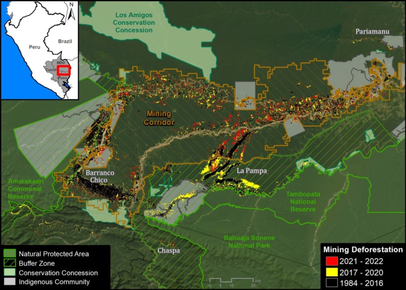
We highlight several important findings illustrated in the Base Map and Table 1, both presented below. In both cases, we highlight recent mining deforestation (between January 2021 and March 2024). Red indicates deforested areas outside of the Mining Corridor (representing our estimate of illegal mining), while yellow indicates recently deforested areas within the Mining Corridor.
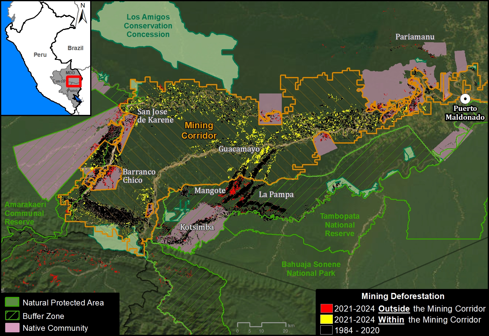
Base Map. Mining deforestation inside and outside the Madre de Dios Mining Corridor, in the southern Peruvian Amazon, between January 2021 and March 2024. Data: ACCA/MAAP.

We found that mining deforestation is concentrated within the Mining Corridor, representing 73.8% of the total (22,756 hectares). This is especially evident in the Guacamayo mining area and along the Madre Dios River.

The rest of the mining deforestation (26.2%) is outside the Mining Corridor. The majority of this deforestation (14.6%) is occurring in the 10 Native Communities of the area, covering a total of 4,494 hectares. The most affected communities are San José de Karene (1,099 ha), Barranco Chico (1,008 ha) and Tres Islas (827 ha), followed by Puerto Luz (305 ha), Boca Inambari (305 ha), Kotsimba (297 ha), San Jacinto (269 ha), Shiringayoc (267 ha), Arazaire (78 ha) and El Pilar (40 ha). However, there are different trends. For example, mining deforestation between 2021 and 2024 has decreased in Barranco Chico, while it has increased in San José de Karene, Tres Islas and Boca Inambari.

We also identified mining deforestation of 2,439 hectares (7.9%) in buffer zones of Protected Areas. The most affected are Tambopata National Reserve (such as the Mangote area, see Figure 1), Bahuaja Sonene National Park, and Amarakaeri Communal Reserve. However, it must be emphasized that mining within the actual Protected Areas has been effectively controlled by the Peruvian government, through the National Service of Protected Natural Areas (SERNANP).

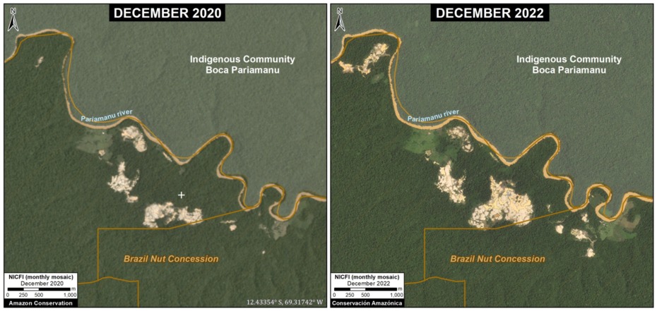
In addition, we detected some mining deforestation (198 hectares) in Brazil nut forestry concessions located in the Pariamanu area.

Finally, it is important to mention that in the critical area known as La Pampa (noted above), the expansion of mining deforestation has been effectively stopped after Operation Mercury. A recent report (MAAP #193), however, showed a large increase in mining activity in previously deforested areas of La Pampa.
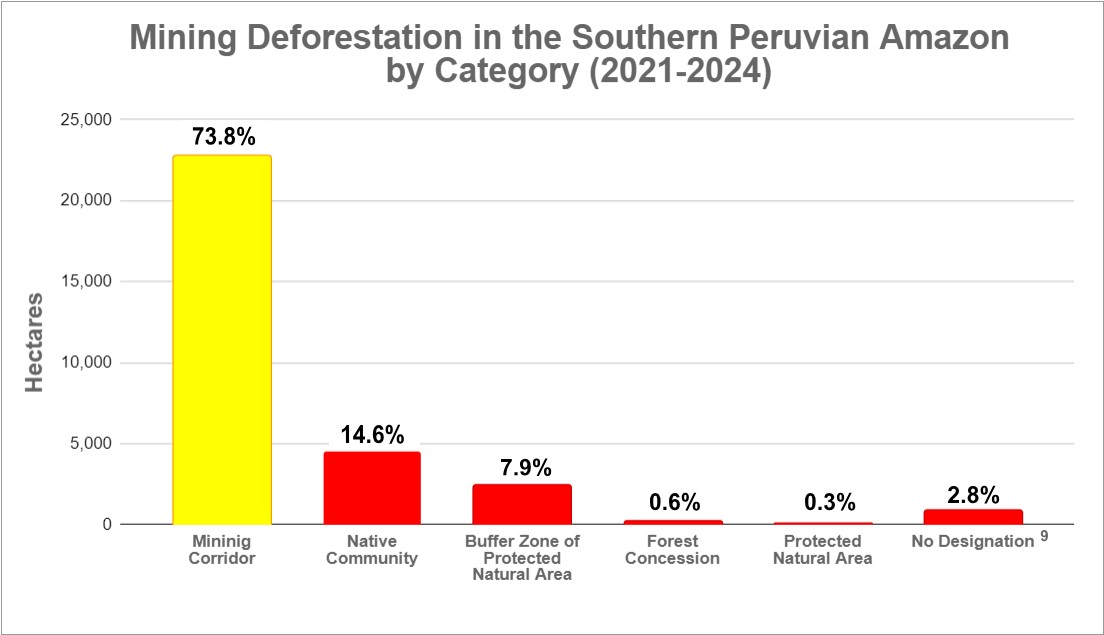
Table 1. Mining deforestation by category in the southern Peruvian Amazon, between January 2021 and March 2024. Data: ACA/MAAP.

Monitoring & Control of Native Communities by FENAMAD

As noted above, a large portion of the illegal mining deforestation in the southern Peruvian Amazon is occurring within the territory of the Native Communities. These Native Communities are part of an articulated federation known as FENAMAD, which is the regional representative organization of the indigenous peoples of the Madre de Dios River basin. FENAMAD defends the fundamental and collective rights of indigenous peoples and native communities, including indigenous peoples in situations of isolation and initial contact.

1. First, FENAMAD identifies priority communities threatened by illegal mining and requiring urgent monitoring.

2. Subsequently, Amazon Conservation leads real-time satellite monitoring in these prioritized communities and delivers confidential reports to FENAMAD.

3. FENAMAD then reviews the reports together with the territory monitors and the results are shared with the affected native communities who decide whether these cases require a legal process.

4. FENAMAD formulates the Environmental Legal Complaint files and delivers them to the corresponding government institutions (Prosecutor’s Office Specialized in Environmental Matters of Madre de Dios –FEMA, National Police of Peru –PNP, Ecological Police of Peru, among others).

5. Finally, in selected cases, the government organizes and directs an on-the-ground operation against illegal mining activity and associated equipment.

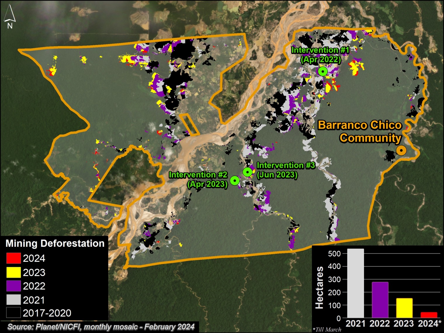
This process has led to the execution of 5 government-led operations between 2022 and 2024, in three communities: Barranco Chico, Kotsimba and San José de Karene (see Base Map).

Of these operations, 3 took place in the community of Barranco Chico,5 which has been especially affected by illegal mining deforestation (967 hectares in the last three years). Figure 2 indicates the location of these operations. It should be noted that mining deforestation in Barranco Chico has decreased between 2021 and 2024, likely due to these types of interventions.

Figure 2. Location of operations against illegal mining in the Barranco Chico Native Community.

The other operations occurred in the communities of Kotsimba6 and San José de Karene7.

It is worth noting that this collaboration between FENAMAD and Amazon Conservation, which is supported by the Norwegian Agency for Development Cooperation (NORAD), is currently expanding to additional native communities within the impacted region.

Notes

1 USAID Prevent works with the Government of Peru, civil society and the private sector to prevent and combat environmental crimes for the conservation of the Peruvian Amazon, particularly in the regions of Loreto, Madre de Dios and Ucayali. USAID’s Prevent Project also has support from the Norwegian Agency for Development Cooperation (NORAD).

2 Previous MAAP reports about gold mining in the southern Peruvian Amazon:

MAAP #195: GOLD MINING DEFORESTATION IN THE SOUTHERN PERUVIAN AMAZON, 2021-2023
https://www.maapprogram.org/2023/mining-deforest-peru
November 2023

MAAP #185: GOLD MINING DEFORESTATION IN THE SOUTHERN PERUVIAN AMAZON: 2021-2022 UPDATE
https://www.maapprogram.org/2023/peru-gold-mining-update/
June 2023

MAAP #171: DEFORESTATION IN MINING CORRIDOR OF PERUVIAN AMAZON (2021-2022)
https://www.maapprogram.org/2022/mining-corridor-peru/
December 2022

MAAP #154: ILLEGAL GOLD MINING IN THE PERUVIAN AMAZON – 2022 UPDATE
https://www.maapprogram.org/2022/gold-mining-peru-update/
May 2022

3 The Mining Corridor, named by Legislative Decree No. 1100, as the “Zone of small mining and artisanal mining in the department of Madre Dios”, catalogs mining activities as:

– Formal: It is carried out with authorization for exploration and exploitation in a specific area, with conditions and operations regulated by the legal framework of the mining sector. It has approved environmental, administrative and operational permits.

– Informal: Artisanal and small-scale mining operates in permitted areas for mineral extraction and uses permitted machinery. Although it does not have authorization to carry out mining activity, it is in the formalization process in accordance with the provisions of Legislative Decree No. 1105, which establishes provisions for the formalization process of small-scale mining and artisanal mining activities. Therefore, it is considered an administrative infraction, but not a crime.

– Illegal: Exploration, extraction and exploitation of mineral resources in prohibited areas (such as Protected Areas and bodies of water) and using prohibited machinery, failing to comply with administrative, technical and environmental requirements established in Peruvian legislation. This is a crime stipulated in article 207-A of the Penal Code, which carries a custodial sentence.

4 Although keep in mind that there may be mining concessions within the Native Community territories.

5 FEMA operations in the Barranco Chico community occurred in April 2022 (América Televisión video), April 2023 (El Comercio) and June 2023. There was an initial operation before the project in 2021.

6 FEMA operation in the Kotsimba community occurred in October 2023.

7 FEMA operation in the community of San José de Karene occurred in April 2024.

8 Of this total (30,846 hectares), 28,292 hectares occurred during 2021-2023, while 2,554 hectares occurred in the first quarter of 2024.

9 Undesignated refers to areas without a formal designation and not included in any of the other categories.

Methodology

We used LandTrendR, a temporal segmentation algorithm that identifies changes in pixel values over time, to detect forest loss within the mining corridor between January 2021 and March 2024 using the Google Earth Engine platform. Importantly, this method was originally designed for moderate resolution Landsat imagery (30 meters)1, but we adapted it for higher spatial resolution (4.7 meters) NICFI-Planet monthly mosaics.2

In addition, we created a baseline for the period 2016 – 2020 to eliminate previously deforested areas (pre 2021), to account for rapid changes in the natural revegetation process.

Finally, we manually separated forest loss from mining vs other causes, to report specifically on direct mining-related impacts between 2021 and 2024. We used several resources to help this manual process, such as alerts with radar images (RAMI) from the SERVIR Amazonía program, historical data from the Amazon Scientific Innovation Center – CINCIA (from 1985 to 2021), and forest loss data from the Peruvian state (National Forest Conservation Program for Climate Change Mitigation) and the University of Maryland.

  1. Kennedy, R.E., Yang, Z., Gorelick, N., Braaten, J., Cavalcante, L., Cohen, W.B., Healey, S. (2018). Implementation of the LandTrendr Algorithm on Google Earth Engine. Remote Sensing. 10, 691.
  2. Erik Lindquist, FAO, 2021

Acknowledgments

We especially thank FENAMAD for this important strategic collaboration.

This report was prepared with the technical support of USAID through the Prevent Project. Prevent (Proyecto Prevenir in Spanish) works with the Government of Peru, civil society, and the private sector to prevent and combat environmental crimes for the conservation of the Peruvian Amazon, particularly in the regions of Loreto, Madre de Dios, and Ucayali. USAID’s Prevent Project also has support from the Norwegian Agency for Development Cooperation (NORAD).

This publication is made possible by the generous support of the American people through USAID. The contents are the sole responsibility of the authors and do not necessarily reflect the views of USAID or the United States Government.

Citation

Finer M, Mamani N (2024) Gold mining in the southern Peruvian Amazon, summary 2021-2024. MAAP: 208.

 

MAAP #200: State of the Amazon in 2023

The first MAAP report, published in March 2015, took a detailed look at the escalating gold mining deforestation in the Peruvian Amazon.

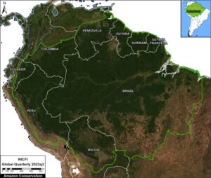
Figure 1. Most recent cloud-free view of the entire Amazon biome (2023, quarter 3). Data: Planet, NICFI, ACA/MAAP.

The following 198 reports, over the past 8.5 years, continued to examine the most urgent deforestation-related issues across the Amazon.

For our 200th report, we provide our rapid assessment of the current state of the Amazon.

Overall, the situation is dire, with the Amazon nearing two critical deforestation-induced tipping points. The first is the widely feared conversion of moist rainforests to drier savannahs, due to decreased moisture recycling across the Amazon (see MAAP #164). The second is the more newly feared conversion of the Amazon as a critical carbon sink buffering global climate change, to a carbon source fueling it (see MAAP #144).

There is cause for hope, however. It is possible in the long term to protect the core Amazon, as nearly half is now designated as protected areas and indigenous territories, both of which have much lower deforestation rates than surrounding areas (see MAAP #183). Also, new NASA data reveals the Amazon is still home to abundant carbon reserves in these core areas (see MAAP #160 and MAAP #199).

Also on the positive news front, we recently reported a major reduction (over one-half) in primary forest loss between the current year 2023 and last year 2022 across the Amazon, especially in Brazil and Colombia (MAAP #201).

Much is made about Amazon fires in the media, but over the past several years we have revealed that the vast majority of major fires across the Amazon (namely, in Brazil, Bolivia, Peru, and Colombia) are actually burning recently deforested areas (MAAP #168). It is only during intense dry seasons that some of these fires escape and become actual forest fires.

Figure 1 shows the most recent cloud-free view of the entire Amazon biome. On the positive, one can clearly see the core Amazon still stands. On the negative, however, the expanding deforestation around the edges is evident.


Major Deforestation Fronts – 2023

In this section, we review the current major deforestation fronts across the Amazon.

Figure 2 indicates these fronts (insets A-H) in relation to deforestation hotspot data over the past 8 years during MAAP’s active monitoring timeframe (2015-2022). Below we describe each deforestation area, by country. Common drivers across numerous Amazon countries include roads (MAAP #157), agriculture (MAAP #161), cattle, and gold mining (MAAP #178).

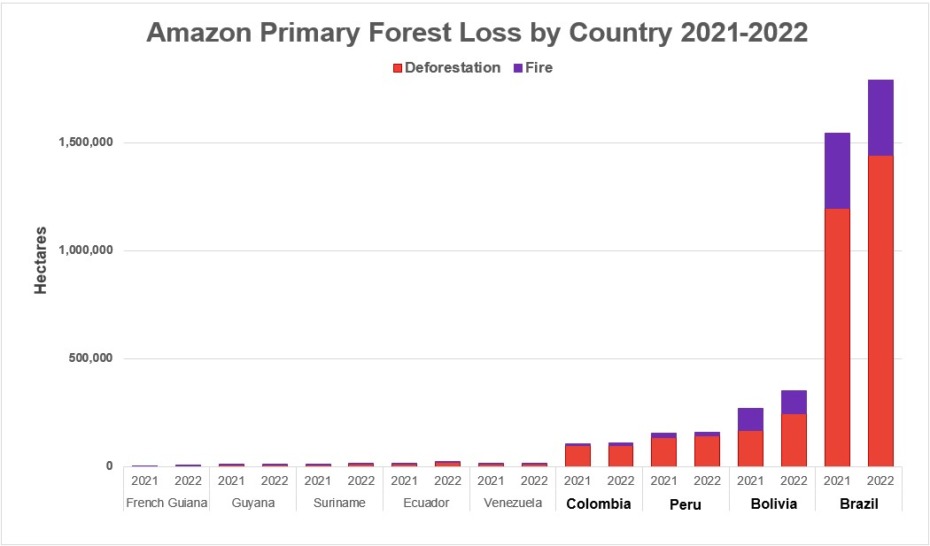
Also note that further below, in the Annex, we show the relative order of total Amazon primary forest loss by country over the past two years: Brazil by far the highest, followed by a middle pack of Bolivia, Peru, and Colombia, followed by lower levels in Venezuela, Ecuador, Suriname, Guyana, and French Guiana.

Figure 2. Amazon forest loss hotspots, 2015-2022. Data: UMD, Planet/NICFI, ACA/MAAP.


Brazilian Amazon

Figure 3. Major forest loss hotspots in the Brazilian Amazon. Data: UMD, Planet/NICFI, ACA/MAAP.

Brazil continues to be, by far, the leading source of Amazonian deforestation (MAAP #187), led by three major drivers: cattle pasture expansion near roads, soy plantations, and gold mining.

Deforestation for new cattle pasture is concentrated along the extensive road networks spanning the eastern and southern Brazilian Amazon (for example, Inset A).

Deforestation for expanding soy plantations is concentrated in the southeast Brazilian Amazon (Inset B; see MAAP #161).

Gold mining deforestation impacts numerous sites, including several indigenous territories (for example, Inset C; see MAAP #178).

Bolivian Amazon

Figure 4. Major forest loss hotspots in the Bolivian Amazon. Data: UMD, Planet/NICFI, ACA/MAAP.

Bolivia has emerged as the clear second-leading source of Amazonian deforestation, with a major increasing trend over the past two years (MAAP #187).

The deforestation is concentrated in the soy frontier located in the southeast (Inset D, see MAAP #179).

Note that, increasingly, this soy deforestation is carried out by Mennonite colonies (MAAP #180). We revealed that Mennonites caused the deforestation of over 210,000 hectares since 2001, including 33,000 hectares since 2017.

Peruvian Amazon

Figure 5. Major forest loss hotspots in the Peruvian Amazon. Data: UMD, Planet/NICFI, ACA/MAAP.

Peru is the third-leading source of Amazonian deforestation (MAAP #187).

In the central Amazon, we have been highlighting the rapid deforestation for new Mennonite colonies (see MAAP #188). MAAP reports revealed, in real-time, Mennonite deforestation growing from zero in 2016, to 3,400 hectares in 2021, to 4,800 hectares in 2022, to 7,032 hectares in 2023.

In the southern Amazon, gold mining deforestation continues to be a major cause of deforestation, primarily in indigenous communities, protected area buffer zones, and within the official Mining Corridor (MAAP #185). Most recently, we showed that gold mining has caused the deforestation on nearly 24,000 hectares between just 2021 and 2023 (MAAP #195).

Colombian Amazon

Figure 6. Major forest loss hotspots in the Colombian Amazon. Data: UMD, Planet/NICFI, ACA/MAAP.

Colombia is the fourth-leading source of Amazonian deforestation.

Deforestation in Colombia spiked following the 2016 peace agreement between the Colombian government and the FARC guerilla group (MAAP #120), but was the only country with a notable deforestation decrease in 2022 (MAAP #187).

Forest loss is concentrated in an “arc of deforestation” surrounding numerous Protected Areas (such as Chiribiquete, Tinigua, and Macarena National Parks) and Indigenous Reserves.

In Colombia, the major direct deforestation driver is cattle pasture, but this expansion is largely caused by land grabbing as a critical indirect driver. Coca plantations also continue to be an important direct driver in certain remote areas.

Both cattle and coca are impacting protected areas, especially Tinigua and Chiribiquete National Parks (cattle); and Macrarena National Park and Nukak National Nature Reserve (coca).

Ecuadorian Amazon

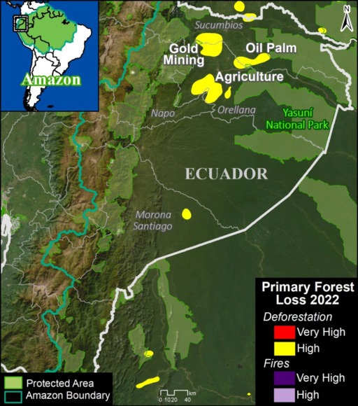
Figure 7. Major forest loss hotspots in the Ecuadorian Amazon. Data: UMD, Planet/NICFI, ACA/MAAP, RAISG.

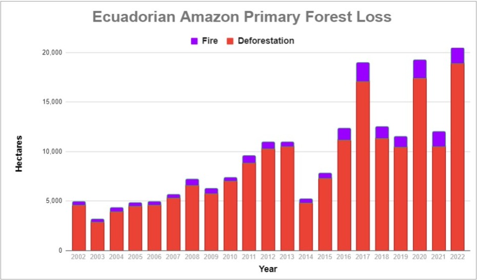
Although accounting for just 1% of total loss across the Amazon, deforestation in the Ecuadorian Amazon was the highest on record in 2022 (18,902 hectares), up a striking 80% since 2021.

There are several deforestation hotspots caused by gold mining (see MAAP #182), oil palm plantation expansion, and small-scale agriculture.

Venezuelan Amazon

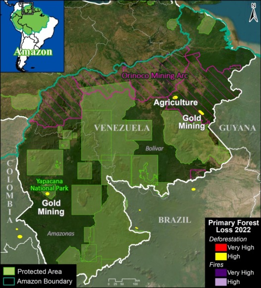
There is a deforestation hotspot caused by gold mining in Yapacana National Park (see MAAP #173MAAP #156MAAP #169).

Annex: Amazon Primary Forest Loss (By Country), 2021-2022

Acknowledgments

We deeply thank the following funders for supporting MAAP over the past 10 years:
International Conservation Fund of Canada (ICFC)
Norwegian Agency for Development Cooperation (NORAD)
United States Agency for International Development (USAID)
MacArthur Foundation
Andes Amazon Fund (AAF)
Wyss Foundation
Erol Foundation
Global Forest Watch/World Resources Institute
Overbrook Foundation
Global Conservation

We also thank our key data providers:
Planet (optical satellite imagery)
University of Maryland (automated forest loss alerts)
Global Forest Watch (portal featuring integrated forest loss alerts)
NICFI monthly mosaics
CLASlite (our original forest loss detection tool)

Citation

Finer M, Mamani N, Novoa S, Ariñez A (2023) State of the Amazon in 2023. MAAP: 200.

MAAP #195: Gold Mining Deforestation in the Southern Peruvian Amazon, 2021-2023

In the context of overall Amazon gold mining, where illegal mining is rampant, southern Peru is an important case study given that the government has created the “Mining Corridor“, where mining is allowed in order to organize and promote this activity.

maaproject.org-maap-195-deforestacion-minera-en-2023-en-la-amazonia-peruana-sur-Panel-A-CorredorMinero2023-Intro-640x580
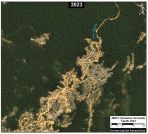
Figure 1. Recent deforestation in the Mining Corridor of the Madre de Dios region in the southern Peruvian Amazon (Guacamayo zone). Data: Planet.

In this large area, officially known as the “Zone of small-scale and artisanal mining in the department of Madre Dios,” mining activity can be formal, informal, or illegal, depending on the location and legal compliance (see more details in the Notes section).

Knowing the level of mining deforestation that occurs within its limits is important because, although it may not be illegal, it can be considerable given that the Mining Corridor covers a large area of almost half a million hectares (498,296 ha).

Indeed, we estimate the mining deforestation of 18,174 hectares within the Mining Corridor over the last three years (2021-2023).

In addition, we identified the mining deforestation of 5,707 hectares outside the Mining Corridor, that is, in prohibited areas and thus likely illegal mining.

Consequently, we found a total mining deforestation of 23,881 hectares (59,011 acres) during this period (2021-2023) in southern Peru.

Of this total, 76% of the deforestation occurred within the Mining Corridor, while the remaining 24% corresponds to surrounding illegal mining.

Base Map: Mining Deforestation in the Southern Peruvian Amazon

The Base Map highlights the most recent mining deforestation in the years 2021-2023 (shown in red) in relation to the historical loss of forests in the area (shown in black), both inside and outside the Mining Corridor.

Base Map. Mining deforestation inside and outside the Madre de Dios Mining Corridor, in the southern Amazon of Peru, during the years 2021 and 2023. Data: ACCA/MAAP.

Note that mining deforestation is concentrated within the Mining Corridor, representing 76% of the total. This is especially evident in the Guacamayo mining area (See Zooms A and B) and along the Madre Dios River.

The rest of the mining deforestation (24%) is outside the Mining Corridor. The majority of this deforestation is occurring in the 10 Indigenous Communities of the area, covering  3,406 hectares. The most affected communities are Barranco Chico (Zoom C), San José de Karene, Tres Islas, and Kotsimba.

Mining deforestation has also been identified in buffer zones of protected natural areas. The most affected are Tambopata National Reserve, Bahuaja Sonene National Park and Amarakaeri Communal Reserve. However, it must be emphasized that mining within protected natural areas has been effectively controlled by the Peruvian State, through the National Service of Protected Natural Areas (SERNANP).

Additionally, a certain amount of mining deforestation (161 hectares) has been detected in Brazil nut forest concessions located in the Pariamanu area (Zoom D).

Finally, it is worth mentioning an area of importance in the buffer zone of Tambopata National Reserve, known as La Pampa (Zoom E). This area was the epicenter of destructive mining deforestation between 2014 and 2018. However, the imagery reveals that after Operation Mercurio, which began in early 2019, the expansion of mining deforestation in La Pampa basically stopped. Despite this, a recent report has shown a large increase in mining activity in previously deforested areas of La Pampa (MAAP #193).
High Resolution Zooms (A-E)

The following high-resolution zooms compare mining deforestation between the year 2020 (left panel) and the current time period of 2023 (right panel). Zooms A and B are located inside the Mining Corridor (Guacamayo area), while Zooms C-E are located outside.

Zoom A. Mining Corridor (Guacamayo zone – west)

Zoom B. Mining Corridor (Guacamayo zone – east)

Zoom C. Barranco Chico Indigenous Community

Zoom D. Brazil Nut Concession, Pariamanu zone

Zoom E. La Pampa

Notes

The Mining Corridor, designated by Legislative Decree No. 1100 as the “Zone for small-scale and artisanal mining in the department of Madre de Dios,” categorizes mining activities as follows:

  • Formal: Completed formalization process with approved environmental and operational permits.
  • Informal: In the process of formalization; Operates only in authorized extraction areas, uses permitted machinery, and is considered an administrative offense, not a crime.
  • Illegal: Operates in prohibited areas such as bodies of water (e.g., rivers or lakes), uses prohibited machinery, is considered a criminal offense, and is punishable by imprisonment.

Methodology

We used LandTrendR, a temporal segmentation algorithm that identifies changes in pixel values over time, to detect forest loss within the Mining Corridor between 2021 and 2023 using the Google Earth Engine platform. It is important to note that this method was originally designed for Landsat images with moderate resolution (30 meters)1, but we adapted it for higher spatial resolution NICFI-Planet monthly mosaics (4.7 meters).2

Additionally, we created a baseline for the period 2016-2020 to eliminate old deforested areas (prior to 2021) due to rapid changes in the natural regrowth process.

Finally, we manually separated forest loss due to mining and other causes between 2021 and 2023 to specifically report on direct impacts related to mining. For this part of the analysis, we used various resources to aid the manual process, such as radar image alerts (RAMI) from the SERVIR Amazonia program, historical data from CINCIA from 1985 to 2020, forest loss data from the Peruvian government (National Forest Conservation Program for Climate Change Mitigation), and the University of Maryland.

  1. Kennedy, R.E., Yang, Z., Gorelick, N., Braaten, J., Cavalcante, L., Cohen, W.B., Healey, S. (2018). Implementation of the LandTrendr Algorithm on Google Earth Engine. Remote Sensing. 10, 691.
  2. Erik Lindquist, FAO, 2021

Acknowledgements

This report was prepared with the technical support of USAID through the Prevent Project. Prevent (Proyecto Prevenir in Spanish) works with the Government of Peru, civil society, and the private sector to prevent and combat environmental crimes for the conservation of the Peruvian Amazon, particularly in the regions of Loreto, Madre de Dios, and Ucayali.

Disclaimer: This publication is made possible by the generous support of the American people through USAID. The contents are the sole responsibility of the authors and do not necessarily reflect the views of USAID or the United States Government.


Citation

Finer M, Mamani N, Ariñez A (2023) Gold Mining Deforestation in the Southern Peruvian Amazon, 2021-2023. MAAP: 195.

MAAP #199: Amazon Carbon Update, based on NASA’s GEDI Mission

As we approach the COP28 climate summit, starting in Dubai in late November, we provide here a concise update on the current state of remaining Amazon carbon reserves.

We present the newly updated version of NASA’s GEDI data1, which uses lasers aboard the International Space Station to provide cutting-edge estimates of aboveground biomass density on a global scale.

Here, we zoom in on the Amazon and take a first look at the newly updated data, which covers the time period of April 2019 – March 2023.2

This data, which is measured in megagrams of aboveground biomass per hectare (Mg/ha) at a 1-kilometer resolution, serves as our estimate for aboveground carbon reserves.

Figure 1 displays aboveground biomass across the Amazon biome. Note the highest carbon densities (indicated in bright yellow) are located in both the northeast Amazon and southwest Amazon.

Aboveground Biomass across the Amazon

Figure 2 also displays aboveground biomass across the Amazon biome, but this time with country boundaries and labels added.

Note that the peak biomass concentrations in the northeast Amazon include Suriname, French Guiana, and the northeast corner of Brazil. The peak biomass concentrations in the southwest Amazon are centered in southern Peru. Also note that many parts of Ecuador, Colombia, Venezuela, Guyana, Bolivia, Brazil, and northern Peru have high carbon densities as well.

Figure 2. Aboveground biomass density (carbon estimate) across the Amazon biome, with country boundaries. Data: NASA/GEDI, NICFI.

Carbon Estimates

We calculated over 78 billion metric tons of aboveground biomass across the Amazon biome (78,184,161,090 metric tons to be exact). Using a general assumption that 48% of this biomass is carbon3, we estimate over 37 billion metric tons of carbon across the Amazon (37,528,397,323 metric tons).

Note that these totals are likely underestimates given that the laser-based data has not yet achieved full coverage across the Amazon (that is, there are many areas where the lasers have not yet recorded data, leaving visible blanks in the maps above).

This is consistent with a previous study based on another independent dataset, where we estimated 6.7 billion metric tons of carbon in the Peruvian Amazon as of 2013 (MAAP #148). The current GEDI data estimates at least 5.3 billion metric tons in the Peruvian Amazon.

Carbon Sink

In a previous report, we showed that the Brazilian Amazon has become a net carbon source, whereas the total Amazon is still a net carbon sink (MAAP #144). Our current report goes one step further in terms of showing just how much carbon is left in that sink.

Notes

1GEDI L4B Gridded Aboveground Biomass Density, Version 2.1. https://daac.ornl.gov/cgi-bin/dsviewer.pl?ds_id=2299

2Note that we previously reported on the initial data release, which covered the time period of April 2019 – August 2021 (see MAAP #160).

3Domke et al (2022) How Much Carbon is in Tree Biomass?. USDA/Forest Service.

Acknowledgements

This work was supported by NORAD (Norwegian Agency for Development Cooperation) and ICFC (International Conservation Fund of Canada).

Citation

Mamani N, Finer M, Ariñez A (2022) Amazon Carbon Update, based on NASA’s GEDI Mission. MAAP: 199.

MAAP #197: Illegal Gold Mining Across the Amazon

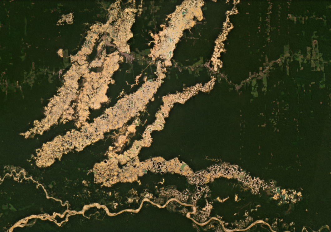
Example of major gold mining zone in the Peruvian Amazon. Data: Planet.

Illegal Gold Mining continues to be one of the major issues facing nearly all Amazonian countries.

In fact, following the recent high-level summit of the Amazon Cooperation Treaty Organization, the nations’ leaders signed the Belém Declaration, which contains a commitment to prevent and combat illegal mining, including strengthened regional and international cooperation (Objective 32).

Illegal gold mining is a major threat to the Amazon because it impacts both primary forests and rivers, often in remote and critical areas such as protected areas & indigenous territories.

That is, illegal gold mining is both a major deforestation driver and a source of water contamination (especially mercury) across the Amazon.

Previously, in MAAP #178, we presented a large-scale overview of the major gold mining deforestation hotspots across the entire Amazon biome. We found that gold mining is actively causing deforestation in nearly all nine countries of the Amazon.

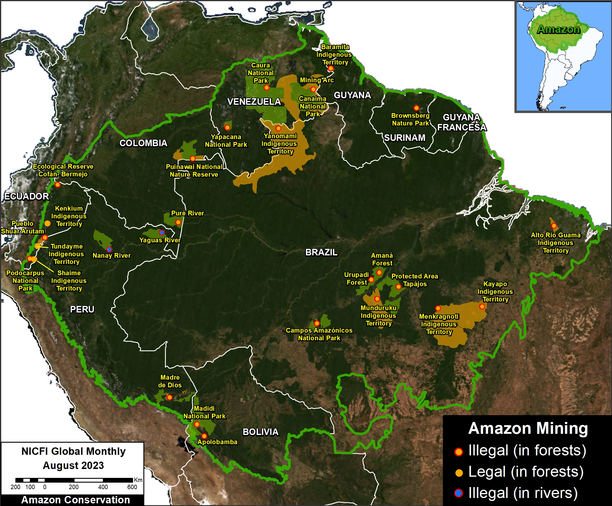
Here, we update this analysis with two important additions. First, we add to the overview major gold mining operations taking place in rivers, in addition to those causing deforestation (see Figure 1).

Second, we present a new map of likely illegal gold mining sites, based on information from partners and location with protected areas and indigenous territories (see Figure 2).

Finally, we show a series of high-resolution satellite images of key examples of illegal Amazon gold mining.

Updated Amazon Gold Mining Map

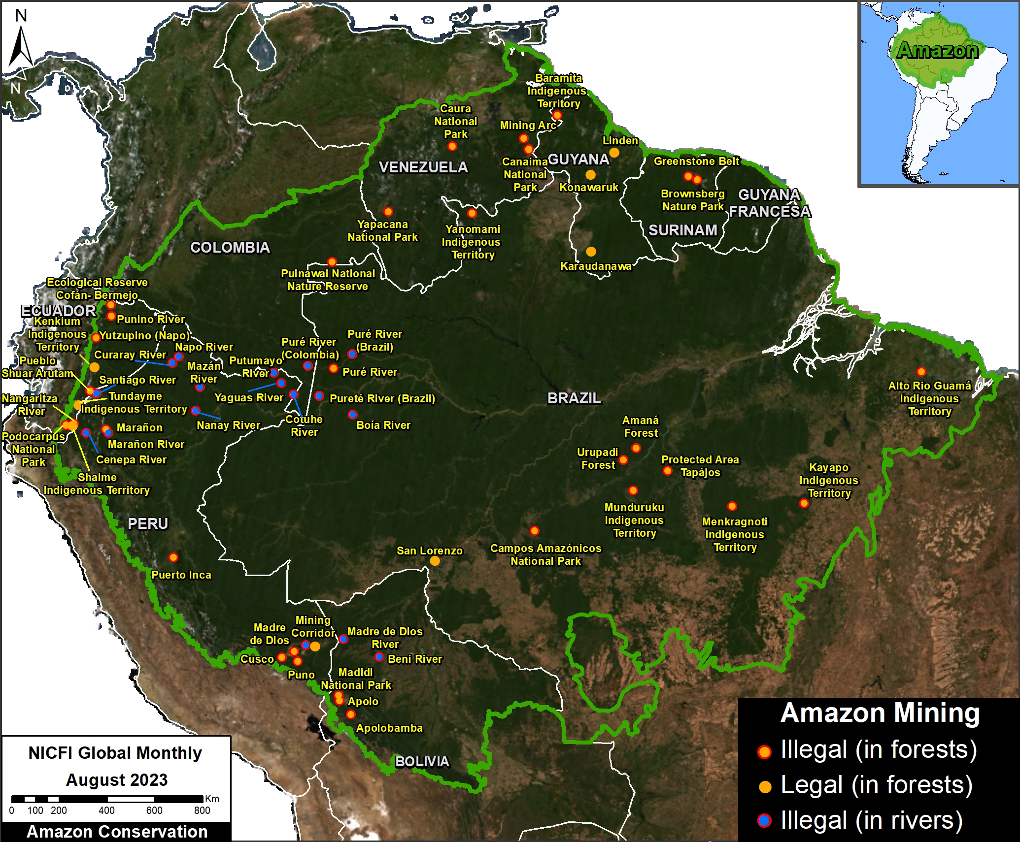
Figure 1 is our updated Amazon gold mining map.

The orange dots indicate areas where gold mining is currently causing deforestation of primary forests. The blue dots indicate areas where gold mining is occurring in rivers. Combined, we documented 58 active forest and river-based mining sites across the Amazon.

The dots outlined in red indicate the mining sites that are likely illegal, for both forest and river-based mining. We found at least 49 cases of illegal mining across the Amazon, the vast majority of the active mining sites noted above.

Note the concentrations of illegal mining causing deforestation in southern Peru, across eastern Brazil, and across Ecuador. Similarly, note the concentrations of illegal mining in rivers in northern Peru and adjacent Colombia and Brazil.

Figure 1. Updated Amazon gold mining map. Data: ACA/MAAP. Click to enlarge.

Protected Areas & Indigenous Territories

Figure 2 adds protected areas and indigenous territories. We found at least 36 conflictive overlaps: 16 in protected areas and 20 in indigenous territories. We also found an additional two conflicts with Brazilian National Forests.

We highlight a number of high-conflict zones. For protected areas: Podocarpus National Park in Ecuador; Madidi National Park in Bolivia; Canaima, Caura, and Yapacana National Parks in Venezuela. We note that the Peruvian government has been effectively minimizing invasions in protected areas in the southern region of Madre de Dios (Tambopata National Reserve and Amarakaeri Communal Reserve).

For indigenous territories: Kayapo, Menkragnoti, Yanomami, and Mundurucu in Brazil; Pueblo Shuar Arutam in Ecuador, and a number of communities in southern Peru.

Figure 2. Amazon gold mining map., with protected areas and indigenous territories. Data: ACA/MAAP, RAISG. Click to enlarge.

Methods

The forest-based mining sites displayed in Figure 1 are largely based on information obtained over the last several years of our deforestation monitoring work. The river-based sites are largely based on information obtained from partners in country and on the ground.

We complemented this information with automated, machine-based data from Amazon Mining Watch, and data from RAISG.

For these sources, we checked recent imagery and only included sites that appeared to still be active.

Classification as an illegal mining site is largely based on location within protected areas or indigenous territories, or clearly
outside of an authorized mining zone

Citation

Finer M, Mamani N, Arinez A, Novoa S, Larrea-Alcázar D, Villa J (2023) Illegal Gold Mining Across the Amazon. MAAP: 197.


MAAP #192: Confirming Deforestation by Mennonites in the Peruvian Amazon

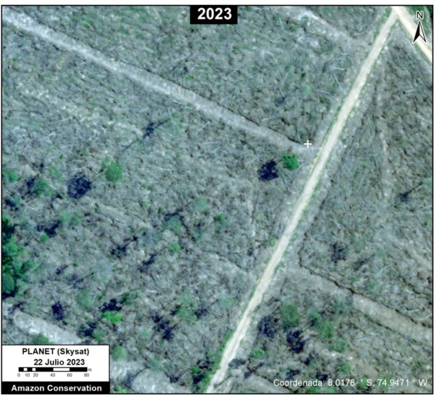
Example of recent 2023 deforestation of primary Amazon forest by Mennonite colony. Data: Planet (Skysat).

In a series of reports, we have documented the recent massive deforestation by Mennonite colonies in the Peruvian Amazon (see MAAP #188).

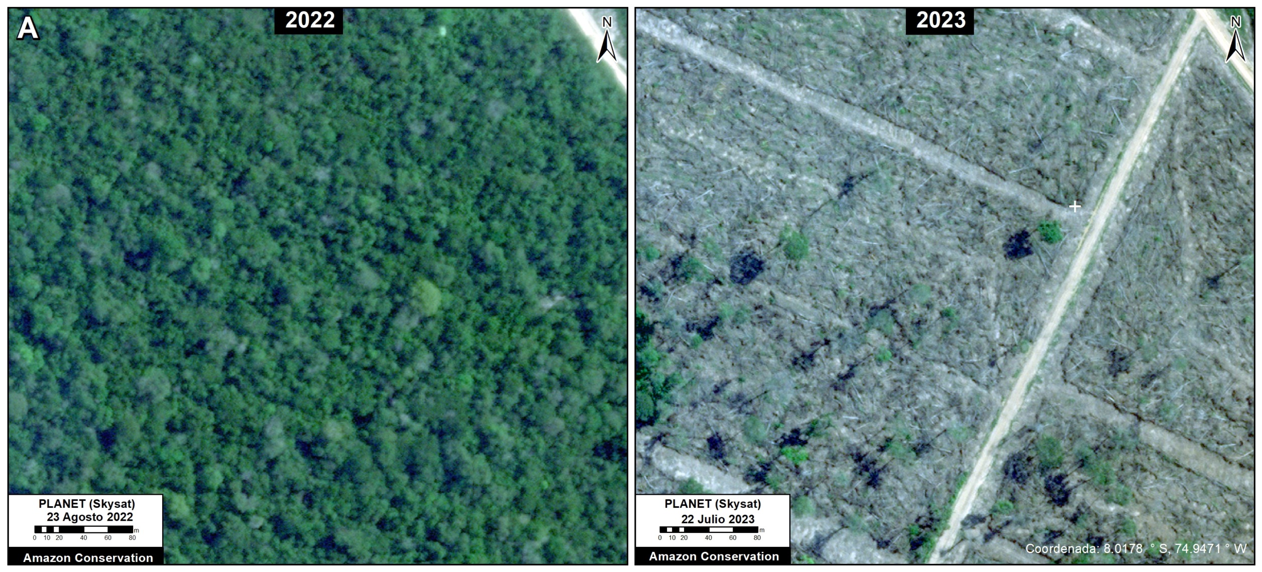
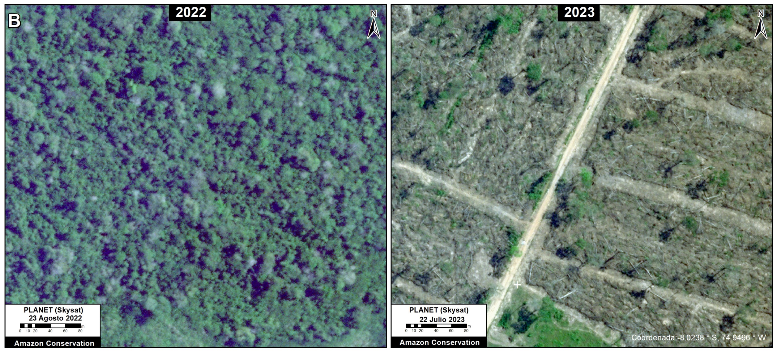
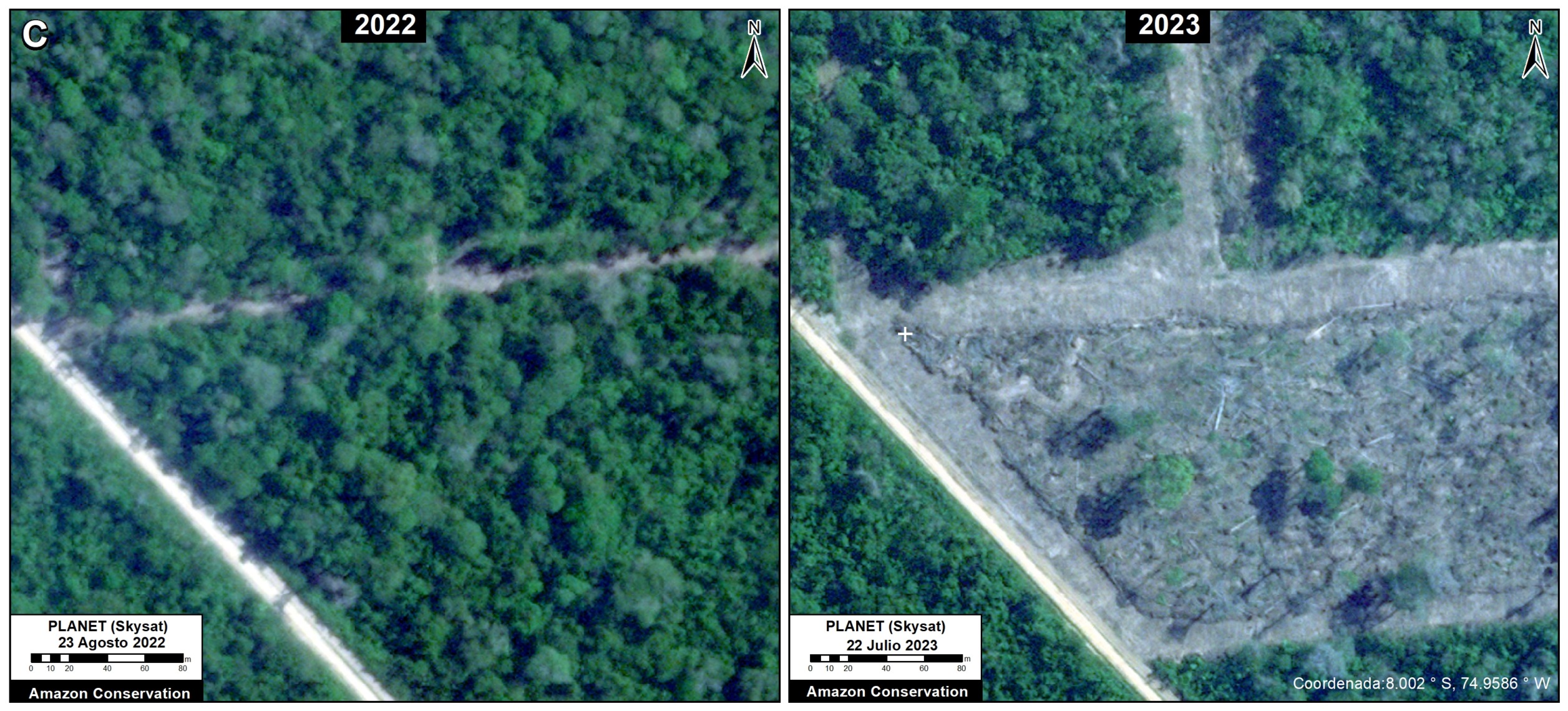
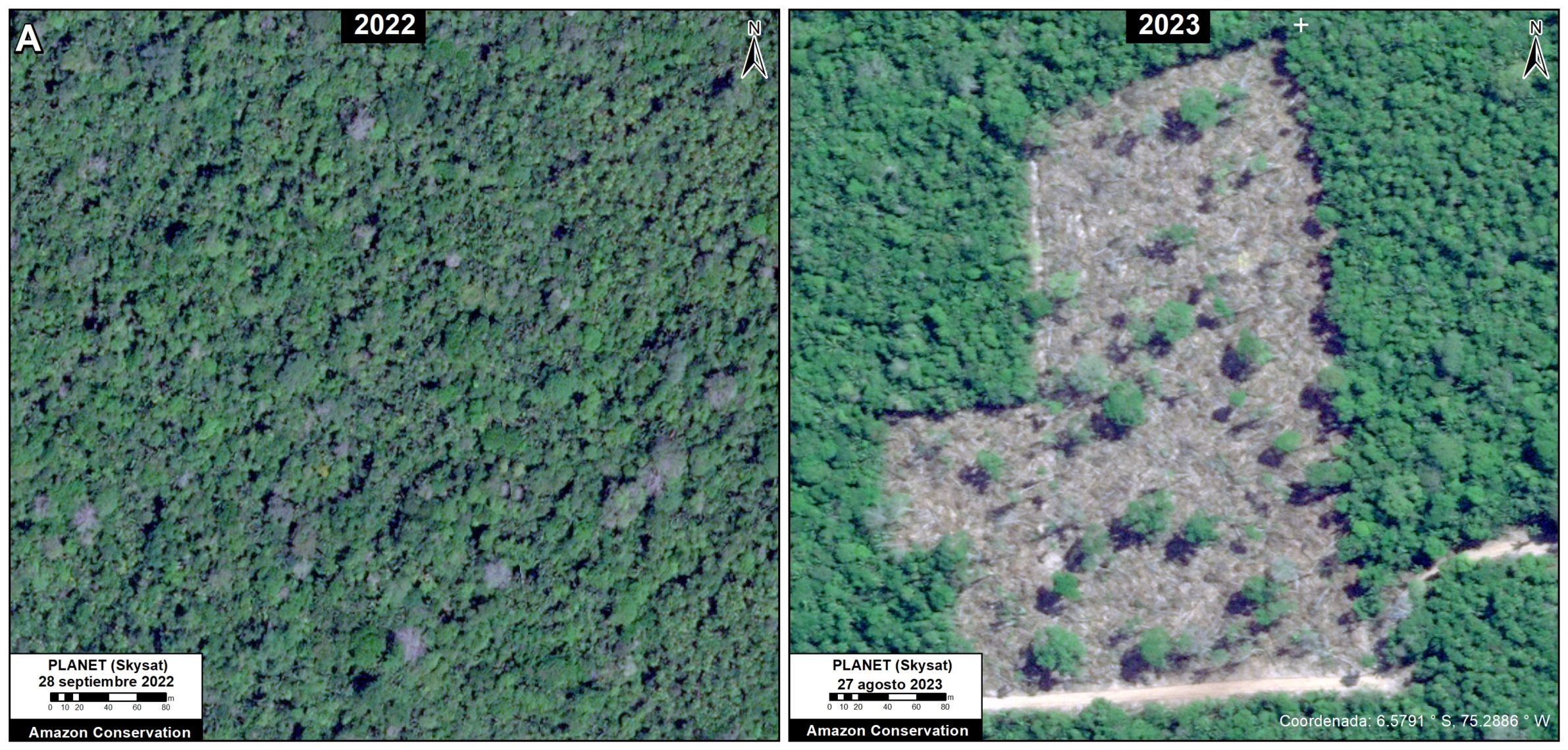
Here, we present additional evidence that Mennonites are currently clearing primary Amazon forests: very high-resolution satellite imagery (0.5 meters from Planet’s Skysat fleet).

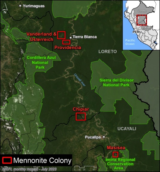
Specifically, we compare a series of very high-resolution satellite images tasked over the same area on different dates across three different Mennonite colonies (Chipiar, Providencia, and Vanderland), located in the regions of Loreto and Ucayali (see Base Map in the Annex).

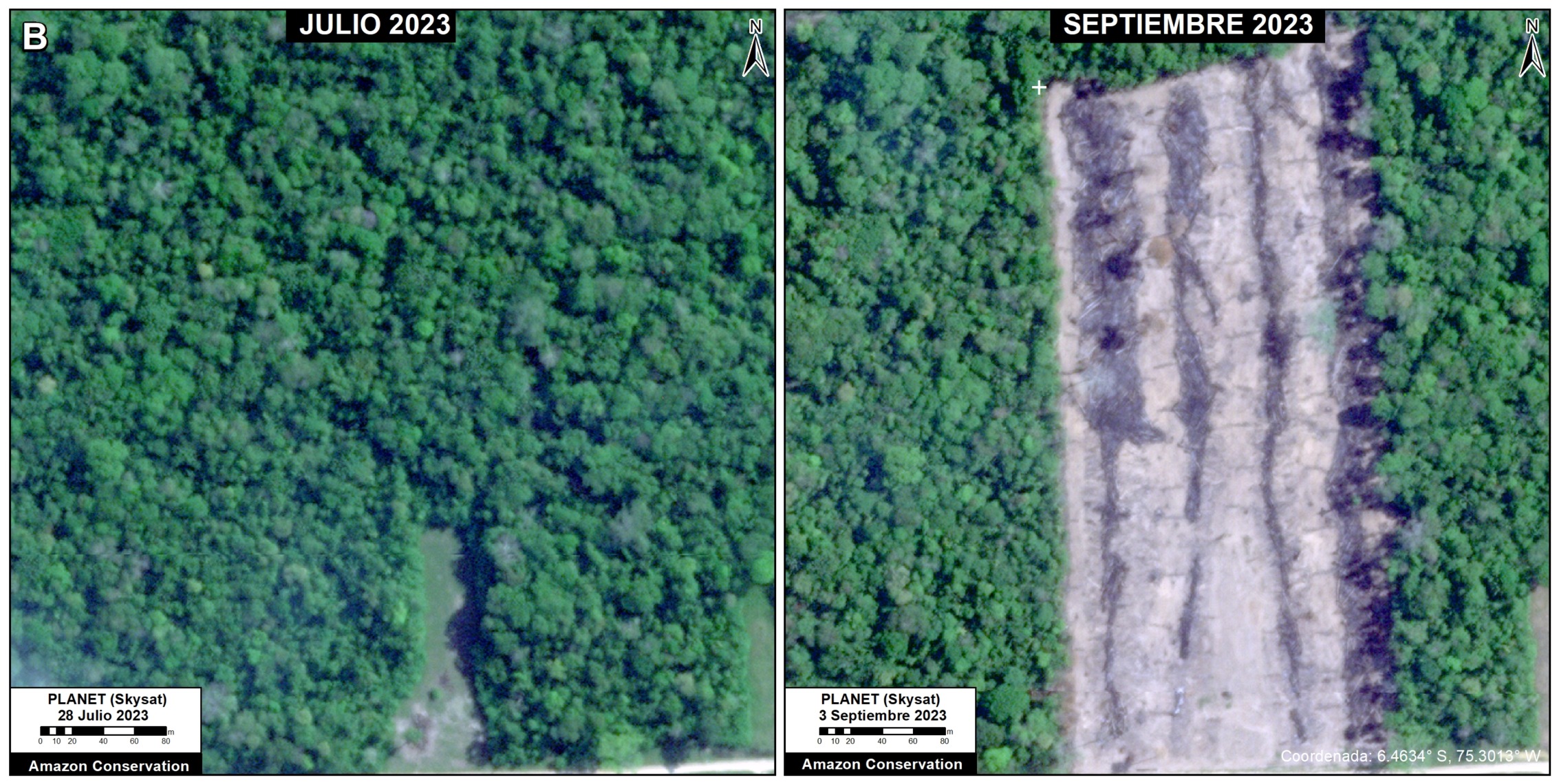
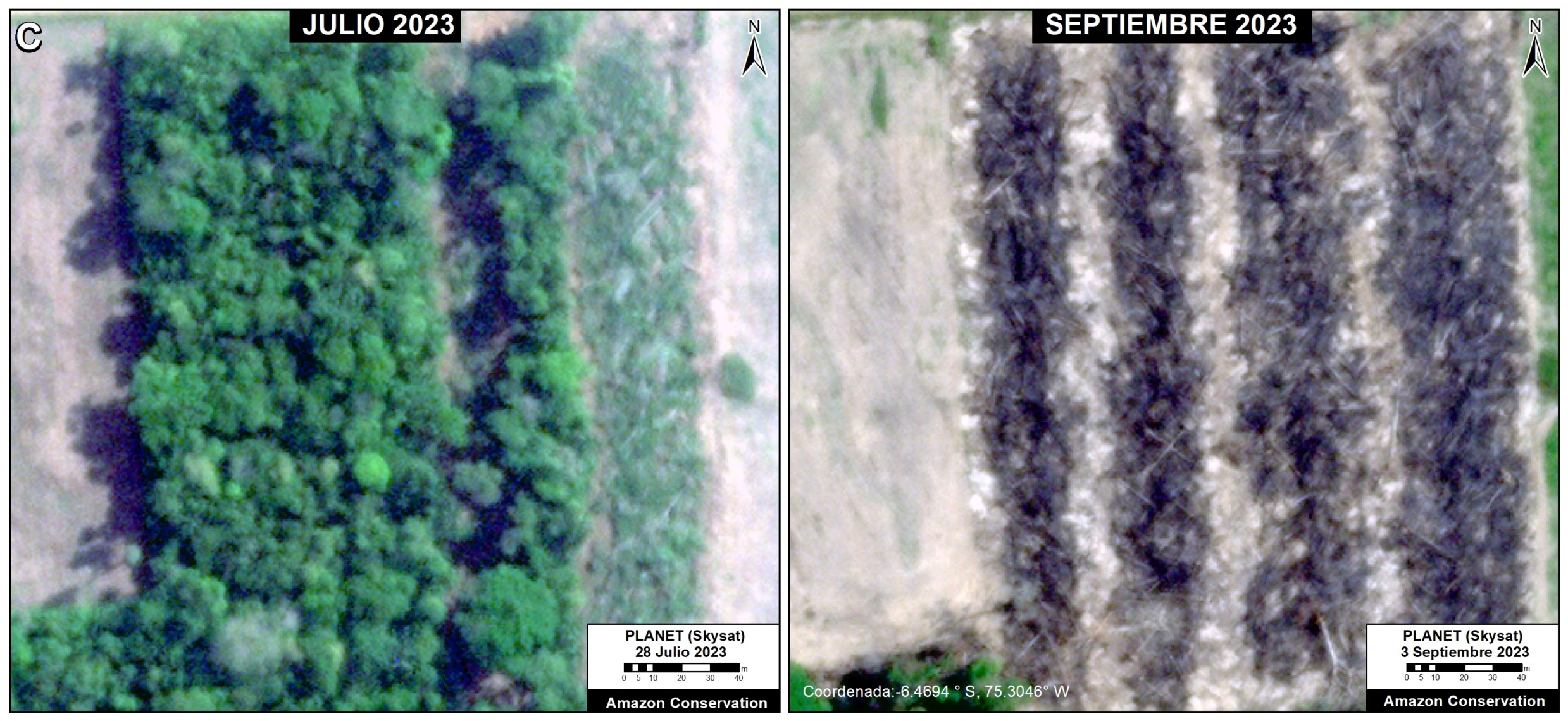
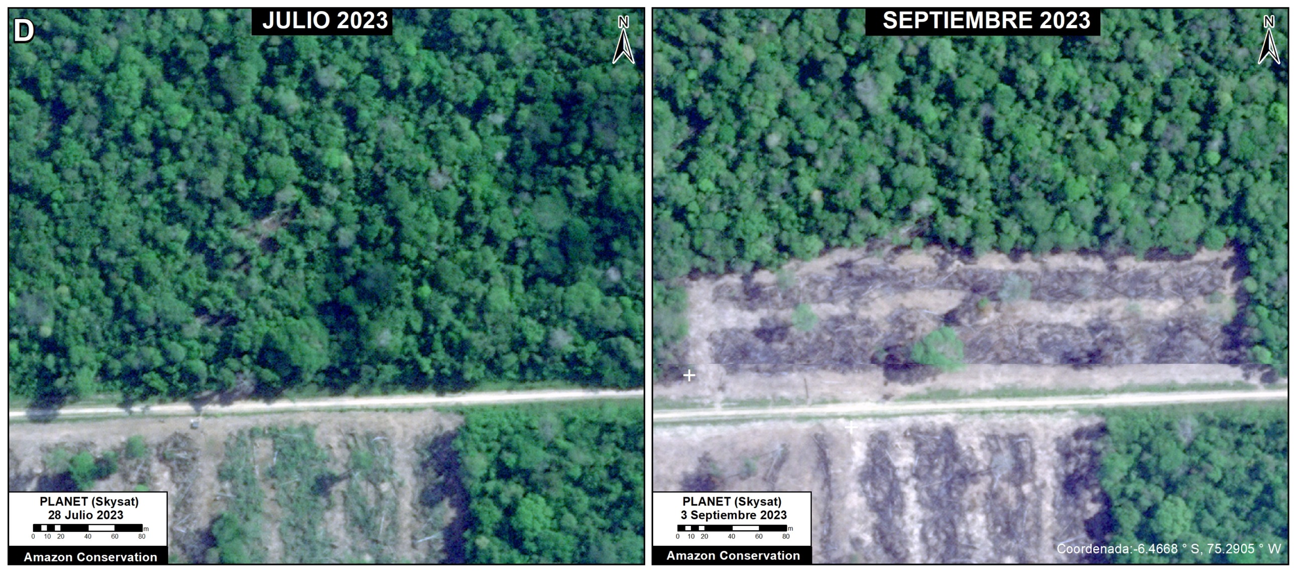
These images conclusively confirm that Mennonites are actively clearing primary forest across multiple sites in the Peruvian Amazon during recent weeks in 2023.


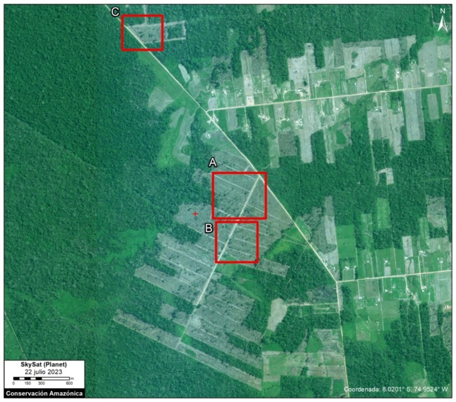
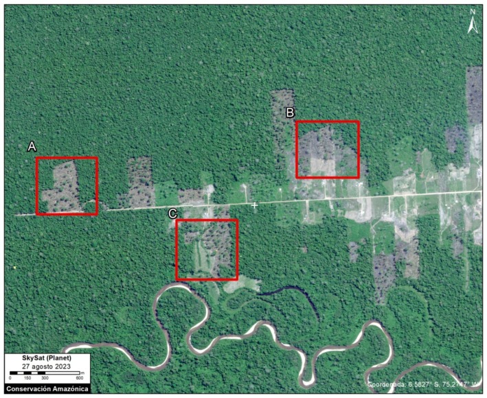
Base Map – Chipiar Mennonite Colony. Data: Planet (Skysat), ACA (MAAP)

Chipiar Colony

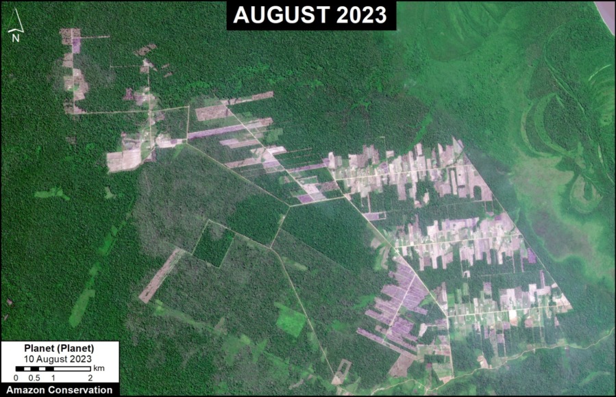
The following image serves as a base map of the recent deforestation in the Chipiar Mennonite colony, located on the border between Loreto and Ucayali.

Insets A-C correspond to the zooms below.

In each of these zooms, we compare very high-resolution images (0.5 meters) obtained in August 2022 (left panels) and July 2023 (right panels).


Zoom A. Chipiar Mennonite Colony. Data: Planet (Skysat)
Zoom B. Chipiar Mennonite Colony. Data: Planet (Skysat)
Zoom C. Chipiar Mennonite Colony. Data: Planet (Skysat)
Base Map – Providencia Mennonite Colony. Data: Planet (Skysat), ACA (MAAP)

Providencia Colony

The following image serves as a base map of the recent deforestation in the Providencia Mennonite colony, located in Loreto.

Insets A-C correspond to the zooms below.

In each of these zooms, we compare very high-resolution images (0.5 meters) obtained in September 2022 (left panels) and August 2023 (right panels).


Zoom A. Providencia Mennonite Colony. Data: Planet (Skysat)
Zoom B. Providencia Mennonite Colony. Data: Planet (Skysat)
Zoom C. Providencia Mennonite Colony. Data: Planet (Skysat)
Base Map – Vanderland Mennonite Colony. Data: Planet (Skysat), ACA (MAAP)

Vanderland Colony

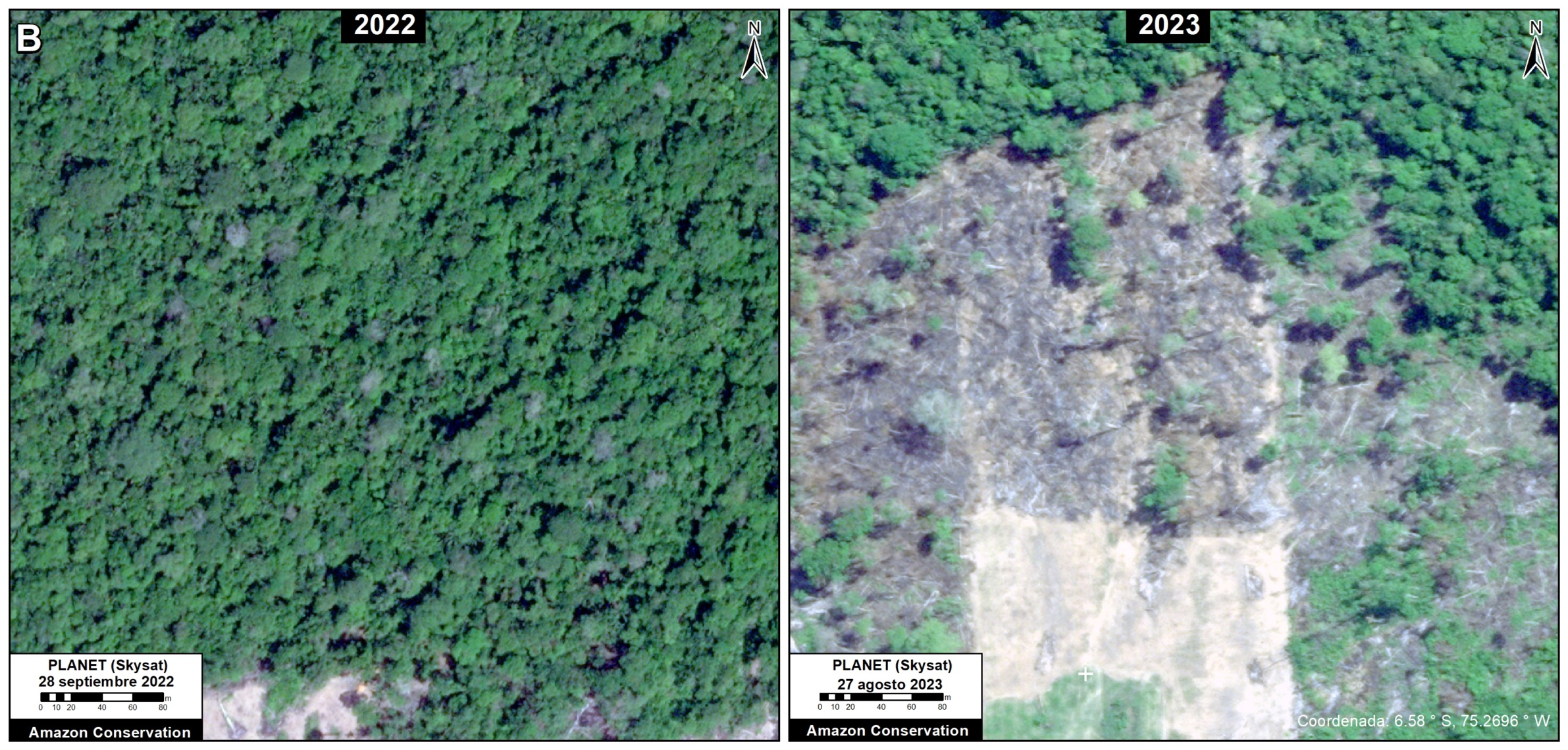
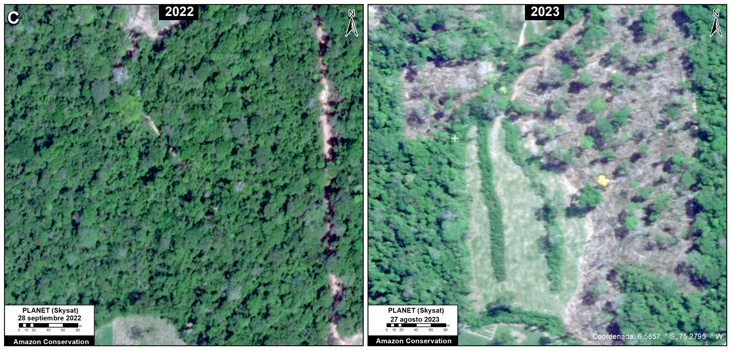
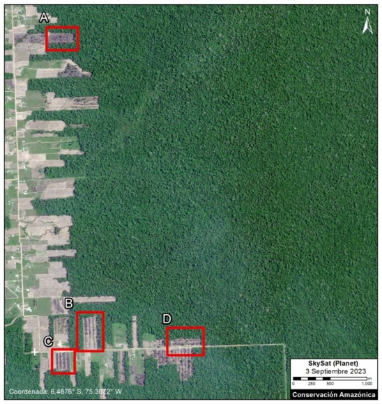
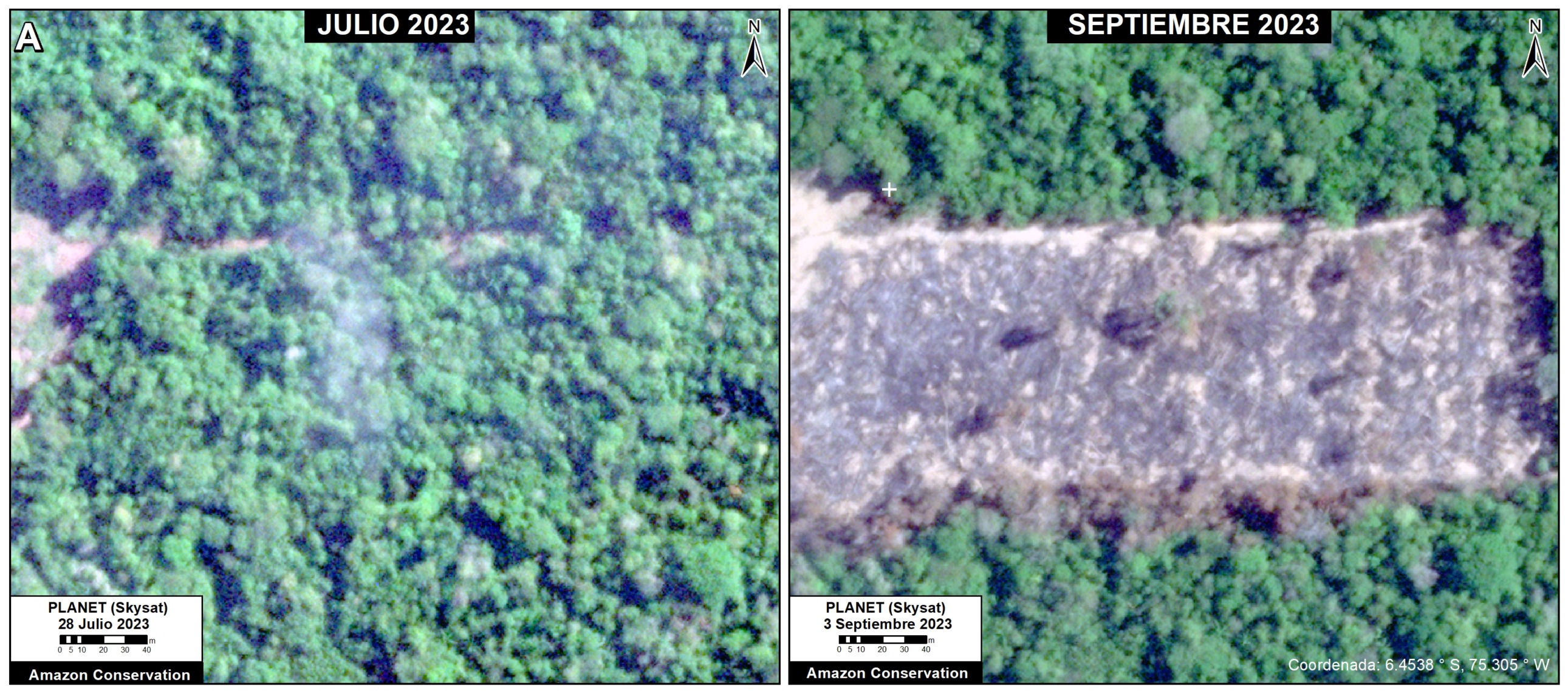
The following image serves as a base map of the recent deforestation in the Vanderland Mennonite colony, also located in Loreto. Insets A-D correspond to the zooms below. In each of these zooms, we compare very high-resolution images (0.5 meters) obtained in July 2023 (left panels) and September 2023 (right panels).


Zoom A. Vanderland Mennonite Colony. Data: Planet (Skysat)
Zoom B. Vanderland Mennonite Colony. Data: Planet (Skysat)
Zoom C. Vanderland Mennonite Colony. Data: Planet (Skysat)
Zoom A. Vanderland Mennonite Colony. Data: Planet (Skysat)

Annex – Base Map of Mennonite Colonies in the Peruvian Amazon

Citation

Finer M, Ariñez A, Mamani N (2023) Confirming Deforestation by Mennonites in the Peruvian Amazon. MAAP: 192.

MAAP #188: Mennonite Colonies Continue Major Deforestation in the Peruvian Amazon

Base Map. Mennonite Colonies in the Peruvian Amazon. Data: ACA/MAAP, SERNANP.

Starting in 2017, new Mennonite colonies began appearing in the Peruvian Amazon, coming from other parts of Latin America in search of new lands.

TheMennonites, a global religious group dating back to the 1600s, often require vast tracts of land to support their characteristic large-scale, industrialized agricultural activity.

In a series of reports, we have demonstrated that the Mennonites have become one of the major deforestation drivers in both the Peruvian and Bolivian Amazon.

Here, we update our findings for Peru for the most recent time period, January 2022 – August 2023.

Our objective is to provide detailed information on the magnitude of deforestation caused by the Menonites in Peru, and to identify the specific colonies where this forest loss is most active now.

Major Findings:

Our analysis has revealed that the Mennonites have now deforested over 7 thousand hectares (7,032 hectares, or 17,376 acres) in the five colonies established since 2017 (Vanderland, Osterreich, Providencia, Chipiar, and Masisea; see Base Map). In addition, we have documented an additional impact of more than 1,600 hectares of burned forests.

Of the total deforestation, more than a third (34.5%) has occurred in the most recent period, from January 2022 to the current date in August 2023 (2,426 hectares, or 5,995 acres).

Below, we detail the deforestation history in each colony, with an emphasis on the most recent loss.

In addition, there is mounting evidence that this massive deforestation is illegal, with numerous ongoing investigations by the Peruvian government (see the Legal Summary, below).

Deforestation in Mennonite Colonies (Peruvian Amazon)

Chipiar Colony

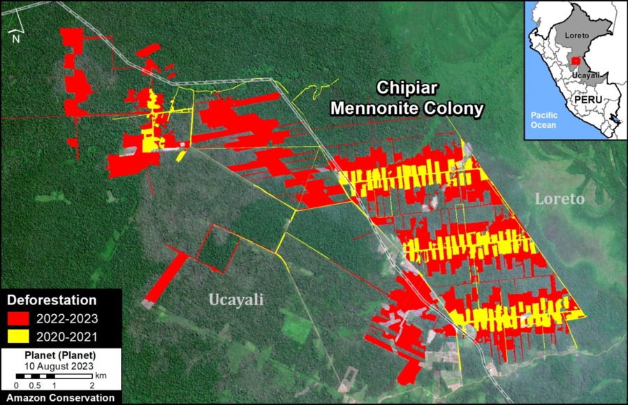
This colony is located on both sides of the border between the departments of Ucayali and Loreto, originating in the district of Padre Marquez on the Loreto side. It is the newest colony, where deforestation began in 2020. This deforestation escalated in 2021, peaked in 2022, and continues to expand in 2023.

In total, we document the deforestation of 2,221 hectares in the Chipiar colony since 2020 (see image below). Much of this loss (76%) occurred in the most recent 2022 – 2023 period.

In addition, we estimate the additional degradation of 1,600 hectares by fires that have escaped from the Mennonite plantations into the surrounding forests.

Figure 1. Deforestation in the Chipiar Mennonite colony. Data: ACA/MAAP, Planet.
Figure 2. Recent image of deforestation in the Chipiar Mennonite colony. Data: Planet.


Vanderland, Osterreich & Providencia Colonies

These three colonies are located near the town of Tierra Blanca, in the Loreto region.

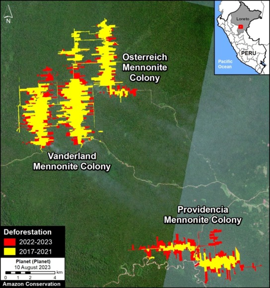
In total, we have documented the deforestation of 3,881 hectares since 2017, with 32.5% occurring in the most recent 2022 – 2023 period (see image below).

Figure 3. Deforestation in Tierra Blanca. Data: ACA/MAAP, Planet.
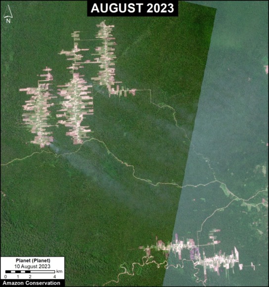
Figure 4. Recent image of deforestation in the Vanderland, Österreich and Providencia. Data: Planet.


Masisea Colony

This colony, located in the Ucayali region, was the first to be established in Peru and was occupied with colonists arriving from Bolivia.

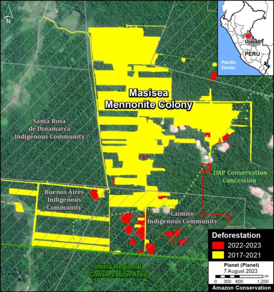
In total, we document the deforestation of 929 hectares in the Masisea colony since 2017 (see image below). Deforestation was highest between 2017 and 2019, and just 6% occurred in the most recent 2022 – 2023 time period.

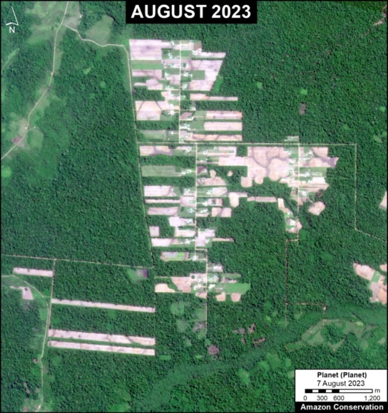
Figura 6. Imagen reciente de la deforestación en la colonia menonita Masisea. Datos: Planet.
Figure 5. Deforestation in the Masisea Mennonite colony. Data: ACA/MAAP, Planet.


Legal Summary

The Specialized Environmental Prosecutor’s Office, known as FEMA (Fiscalia Especializada en Materia Ambiental), is conducting investigations against the Mennonite colonies in each of the three areas:

  • In Masisea, which is the most advanced case, the accusation is for illegal trafficking of timber forest products, crimes against forests in an aggravated form, alteration of the environment or landscape, and crimes against the forests of an indigenous community (tráfico ilegal de productos forestales maderables, delitos contra los bosques en forma agravada y alteración del ambiente o paisaje, y delitos contra los bosques de una comunidad nativa).
    j
  • In the colonies of Tierra Blanca, the accusations include crimes against forests or wooded areas and misuse of agricultural lands (delitos contra los bosques o formaciones boscosas y por utilización indebida de tierras agrícolas).
    j
  • In Chipiar, officially known as the Christian Agricultural Mennonite Colony Gnadenhoff Reinlaender Benboya, the accusation is crime against forests or forest formations in aggravated form (delito contra los bosques o formaciones boscosas en forma agravada).

The Public Prosecutor of the Ministry of the Environment has indicated that all deforestation has occurred without the proper authorization from the relevant state agencies. The regional governments of Ucayali and Loreto have confirmed this assertion, stating that there is no authorization for land use change.

In addition, the National Forest Service (SERFOR) has received five complaints against the Mennonite colonies in the three sectors (two for Masisea, two for Tierra Blanca, and one for Chipiar). These complaints have been forwarded to the respective regional governments and to FEMA in Loreto and Ucayali.

In general, the Mennonites have followed the same pattern in each area: First, there is an irregular purchase of land. Then, they proceed with land use change and deforestation without proper authorization.

In October 2022, the Ucayali Transitory Preparatory Investigation Court for Environmental Crimes (Juzgado de Investigación Preparatoria Transitorio de Delitos Ambientales de Ucayali) ruled in favor of the request of the Attorney General of the Ministry of the Environment, in relation to deforestation in the Chipiar colony. In July 2023, the Second Criminal Appeals Chamber of the Superior Court of Justice of Ucayali (Segunda Sala Penal de Apelaciones de la Corte Superior de Justicia de Ucayali) ratified the immediate suspension of predatory activities of clearing and logging by the colony. According to the judicial order, the members of this Mennonite colony will not be able to use vehicles, machinery or instruments that cause deforestation.

Sources:

Mongabay Latam

https://es.mongabay.com/2022/10/tiruntan-perdio-sus-bosques-tras-la-llegada-de-menonitas-en-peru/

https://es.mongabay.com/2022/02/menonitas-en-peru-tres-colonias-investigadas-por-la-deforestacion-de-casi-4-mil-hectareas-de-bosque-en-la-amazonia/

https://es.mongabay.com/2020/11/menonitas-peru-deforestacion-loreto/

https://es.mongabay.com/2021/04/menonitas-peru-historia-entrega-bosques-masisea/

Ojo Publico

https://ojo-publico.com/ambiente/territorio-amazonas/las-visitas-al-congreso-detras-del-proyecto-que-amenaza-los-bosques

Convoca

https://convoca.pe/investigacion/menonitas-el-grupo-que-convierte-la-fe-religiosa-en-deforestacion-en-la-amazonia-del

https://convoca.pe/investigacion/brechas-legales-permiten-que-los-menonitas-deforesten-la-amazonia-peruana

Actualidad Ambiental

https://www.actualidadambiental.pe/ordena-suspender-depredacion-de-bosques-a-colonia-menonita/

Acknowledgements

We thank colleagues at USAID in Peru and Conservación Amazónica-ACCA for helpful input and comments on this report, and R. McMullen for translation.

This report was prepared with the technical support of USAID through the Prevent Project. Prevent (Proyecto Prevenir in Spanish) works with the Government of Peru, civil society, and the private sector to prevent and combat environmental crimes for the conservation of the Peruvian Amazon, particularly in the regions of Loreto, Madre de Dios, and Ucayali.

Disclaimer: This publication is made possible by the generous support of the American people through USAID. The contents are the sole responsibility of the authors and do not necessarily reflect the views of USAID or the United States Government.

Citation

Finer M, Mamani N (2023) Mennonite Colonies Continue Major Deforestation in the Peruvian Amazon. MAAP: 188.

MAAP #189: Amazon Fire Season Heats Up

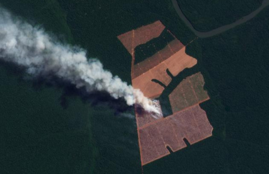
Image 1. Example of 2023 (June 29) major fire in Brazilian Amazon.

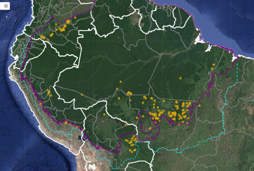
The Amazon fire season is well under way: to date, we have detected over 260 major fires thus far in 2023 (see Base Map below).

This year is of special concern because scientists indicate we have entered a new El Niño episode. The most intense Amazon fire seasons on record, 2016 and 2017, immediately followed the last major El Niño event.

Most of the fires (54%) this year have occurred in the Brazilian Amazon.

Of these, the vast majority (73%) have burned r­­­­ecently deforested areas. This high number is consistent with previous years (see MAAP #168) and once again highlights the critical link between deforestation and fires in the Brazilian Amazon. That is, most major fires are burning the remnants of a recent deforestation event.

It is also worth noting that many of the fires in the Brazilian Amazon (42%) were burning areas recently deforested specifically for new soy plantations.

We have thus far detected 40 major fires in the Bolivian Amazon. The vast majority (88%) have been burning areas recently deforested specifically for new soy plantations.

We have detected an additional 30 major fires in the Peruvian Amazon, mostly burning high elevation grasslands.

Earlier in the year, between January and March, we detected 50 major fires in the Colombian Amazon. Notably, 100% of them were in burning recently deforested areas.

These findings are based on the unique data from the real-time Amazon Fires Monitoring app developed by our partner organization in Peru, Conservación Amazónica ACCA. In a novel approach, the app combines data from the atmosphere (aerosol emissions in smoke) and the ground (heat anomaly alerts) to quickly and precisely detect major fires, defined as fires burning abundant biomass. In short, the app filters out smaller fires (such as routine burning an old field) and highlights major fires (such as burning recently deforested areas, standing forest, or natural grasslands).

2023 Major Amazon Fires Base Map

Base Map. 2023 major Amazon fires (through July 2023). Data: ACCA, ACA/MAAP.

Amazon Fires Dashboard

We also present our new Amazon fires dashboard, which currently shows results for the 2022 fire season. The dashboard highlights a number of the key findings from last year:

  • We detected 983 major fires.
  • The vast majority (72%) were in Brazil, followed by Bolivia, Peru, and Colombia.
  • Importantly, 73% of the major fires burned recently deforested areas, followed by grasslands, forest fires, and pasture.

The dashboard was developed by the SAS Institute’s Data for Good Program.

Methodology

The reported results are based on an analysis of data generated by a unique real-time Amazon Fires Monitoring app during the year 2023, through July 13.

The app, hosted by Google Earth Engine, was developed and updated daily by the Peru-based organization Conservación Amazónica (ACCA). The resulting data was analyzed and recorded daily by the US-based organization Amazon Conservation. The app was created in 2019 and upgraded in 2020, with the current version launching in May 2021.

When fires burn, they emit gases and aerosols (aerosol definition: Suspension of fine solid particles or liquid droplets in air or another gas) as part of the outgoing smoke. A relatively new satellite (Sentinel-5P from the European Space Agency) detects these aerosol emissions.

The aerosol data, which has a spatial resolution of 7.5 sq km, is not impacted by cloud cover, thus enabling near real-time monitoring during all weather conditions. The app is typically updated each day in the late afternoon/early evening with data for that same day. Thus, there is a high potential for authorities and civil society to also use this app to respond to major fires in the field.

Importantly, the app distinguishes small fires (such as from clearing old fields and thus burning little biomass) from larger fires (such as burning recently deforested areas or standing forests and thus burning high amounts of biomass).

We define a “major fire” as one showing elevated aerosol emission levels on the app, thus indicating the burning of elevated levels of biomass. This typically translates to an aerosol index (AI) of >1 (or cyan-green to red on the app).

In a novel approach, the app combines this aerosol data from the atmosphere with heat anomaly data from the ground.

For all detected major fires, we cross-referenced the aerosol emissions pattern with the ground heat-based data to pinpoint the exact location of the fire source. Typically for major fires, there is a large cluster of heat-anomaly alerts aiding the process.

In a final step, the detected major fires are then analyzed with high-resolution optical satellite imagery from Planet Explorer. With this imagery, we can confirm the major fire (by observing smoke on the day of the fire or a burned area scar in the days following the fire) and estimate its size.

Moreover, with Planet’s extensive satellite imagery archive, we can determine the fire type. That is, by comparing imagery from the fire date to previous dates, we can determine whether the fire was burning a) a recently deforested area (defined as fires in areas recently deforested during the past three years), b) an older deforested area (typically long-standing pasture areas), c) standing forest (that is, a forest fire), or natural savannah.

In the app, we can also cross-reference if a major fire has occurred within a protected area or titled indigenous territory.

Note that the high values in the aerosol indices may also be due to other reasons such as emissions of volcanic ash or desert dust so it is important to cross-reference elevated emissions with heat data and optical imagery.

Acknowledgements

This work was supported by Norad (Norwegian Agency for Development Cooperation) and ICFC (International Conservation Fund of Canada).

Citation

Finer M, Costa H, Villa L (2023) Amazon Fire Season Heats Up. MAAP: 189.

MAAP #187: Amazon Deforestation & Fire Hotspots 2022

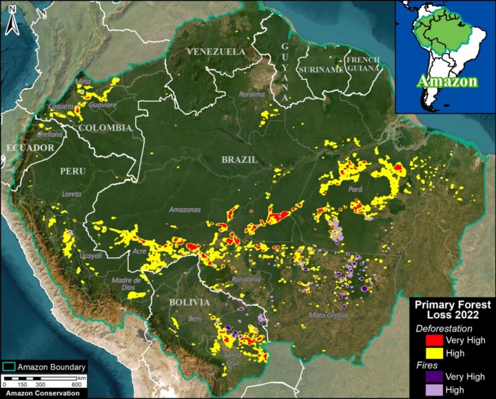
2022 Amazon Forest Loss Base Map. Deforestation and fire hotspots across the full Amazon biome. Data: UMD/GLAD, ACA/MAAP.

We present a detailed look at the major 2022 Amazon forest loss hotspots, based on the final annual data recently released by the University of Maryland (and featured on Global Forest Watch).

This dataset is unique in that it is consistent across all nine countries of the Amazon, and distinguishes forest loss from fire, leaving the rest as a proxy for deforestation (but also includes natural loss).

Thus, we are able to present both deforestation and fire hotspots across the Amazon.

The Base Map (see right) and Results Graph (see below) reveal several key findings:

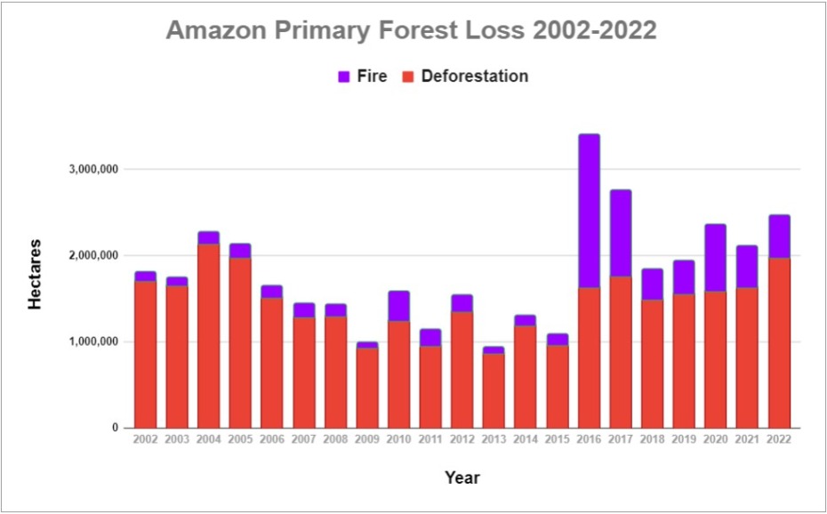
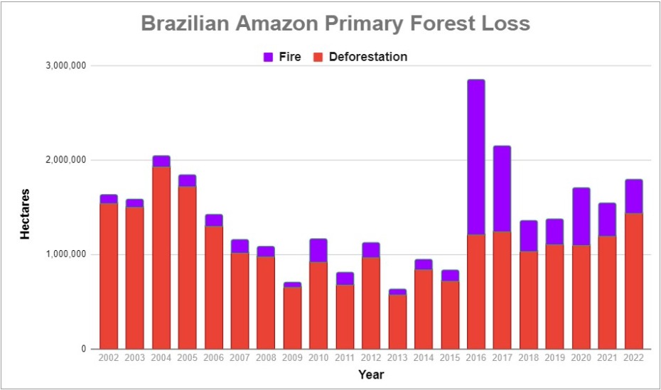
  • In 2022, we estimate the deforestation of 1.98 million hectares (4.89 million acres). This represents a major 21% increase from 2021, and is the second highest on record, behind only the peak in 2004.
    k
  • Deforestation hotspots were especially concentrated along roads in the Brazilian Amazon, the soy frontier in the southeast Bolivian Amazon, and near protected areas in northwest Colombian Amazon.
    k
  • The vast majority of the deforestation occurred in Brazil (72.8%), followed by Bolivia (12.4%)Peru (7.3%), and Colombia (4.9%). Note that deforestation in Bolivia was the highest on record, and in Brazil the highest since the early 2000s.
    k
  • Fires impacted an additional 491,223 hectares (1.2 million acres) of primary forest. This total represents a 1.6% increase from 2021, and the 4th highest on record (behind only intense fire seasons of 2016, 2017, and 2020). Moreover, each of the seven most intense fire seasons has occurred in the past seven years. Nearly 93% of the fire impact occurred in just two countries: Brazil and Bolivia.
    k
  • In total, 2.47 million hectares (6.1 million acres) of primary forest were impacted by deforestation and fire. This total represents the third highest on record, only behind the post-El Niño years of 2016 and 2017.
    k
  • Since 2002, we estimate the deforestation of 30.7 million hectares (75.9 million acres) of primary forest, greater than the size of Italy or the U.S. state of Arizona.

Below, we zoom in on the six countries with the highest deforestation (Brazil, Bolivia, Peru, Colombia, Ecuador, and Venezuela) with additional maps and analysis.

Amazon Primary Forest Loss (Combined), 2002-2022

Amazon Forest Loss Results Graph, 2002-22. Data: UMD/GLAD, ACA/MAAP.

Amazon Primary Forest Loss (By Country), 2002-2022

Brazilian Amazon

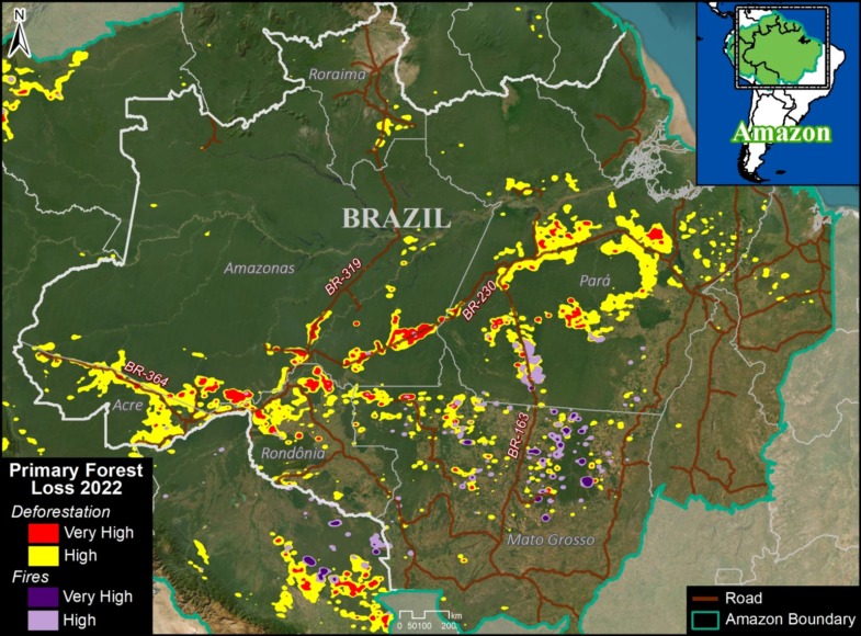
Brazil Base Map, 2022. Deforestation and fire hotspots in the Brazilian Amazon in relation to major roads. Data: UMD/GLAD, ACA/MAAP.

In 2022, the Brazilian Amazon lost 1.4 million hectares (3.56 million acres) of primary forest to deforestation. Fires directly impacted an additional 348,824 hectares.

The deforestation rose 20.5% from 2021, and was the highest on record since the peak years of 2002 – 2005.

The fire impact was the 4th highest on record, only behind the intense fire years of 2016, 2017, and 2020.

The deforestation was concentrated along the major road networks, especially roads 230 (Trans-Amazonian Highway), 364, 319, and 163 in the states of Amazonas, Pará, Rondônia, and Acre (see Brazil Base Map).

The direct fire impacts were concentrated in the soy frontier, located in southeastern state of Mato Grosso


Bolivian Amazon

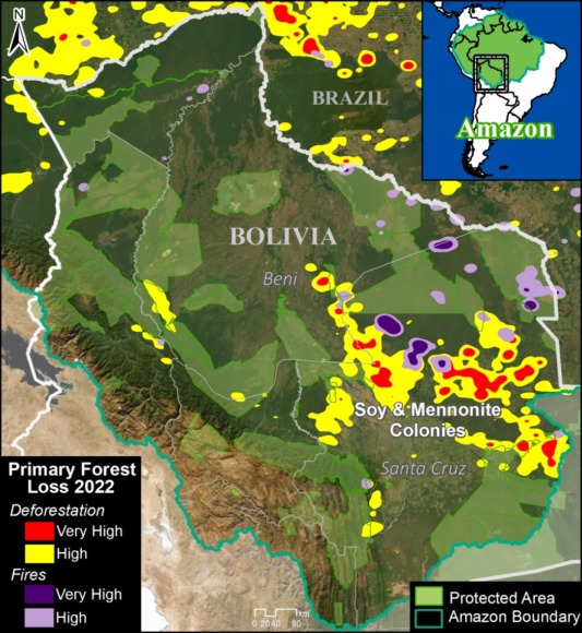
Bolivia Base Map, 2022. Deforestation and fire hotspots in Bolivian Amazon. Data: UMD/GLAD, ACA/MAAP.

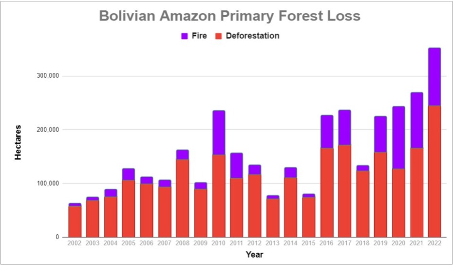
In 2022, the Bolivian Amazon lost 245,177 hectares of primary forest to deforestation. Fires directly impacted an additional 106,922 hectares.

We highlight that this deforestation was 47% higher than 2021, and the highest on record (by far).

The fire impact was also up from last year, and the second-highest on record behind just the intense year of 2020.

Both the deforestation and fires were concentrated in the soy frontier located in southeastern department of Santa Cruz (see Bolivia Base Map).


Peruvian Amazon

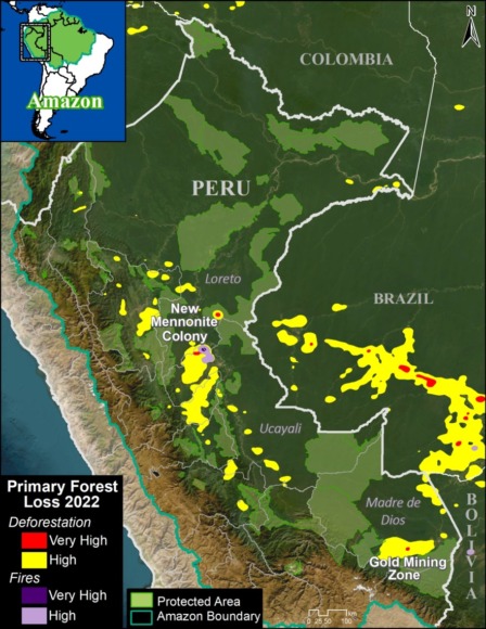
Peru Base Map, 2022. Deforestation and fire hotspots in the Peruvian Amazon. Data: UMD/GLAD, ACA/MAAP.

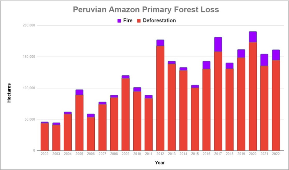
In 2022, the Peruvian Amazon lost 144,682 hectares of primary forest to deforestation. Fires directly impacted an additional 16,408 hectares.

Deforestation increased 6.7% from 2021, and was the 5th highest on record. Fire impact decreased from last year, but was still relatively high.

The deforestation was concentrated in the central and southern Amazon (Ucayali and Madre de Dios regions, respectively) (see Peru Base Map).

In the central Amazon, we highlight the rapid deforestation for a new Mennonite colony (see MAAP #166).

In the southern Amazon, gold mining deforestation continues to be an issue in indigenous communities and within the official Mining Corridor.


Colombian Amazon

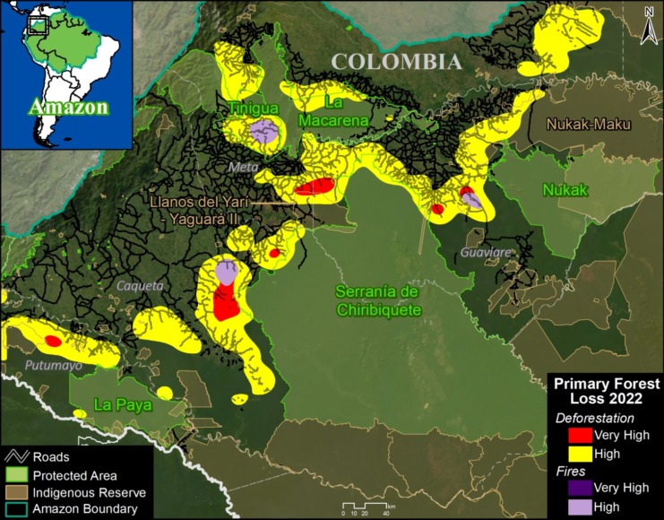
Colombia Base Map, 2022. Deforestation and fire hotspots in northwest Colombian Amazon. Data: UMD/GLAD, ACA/MAAP, FCDS.

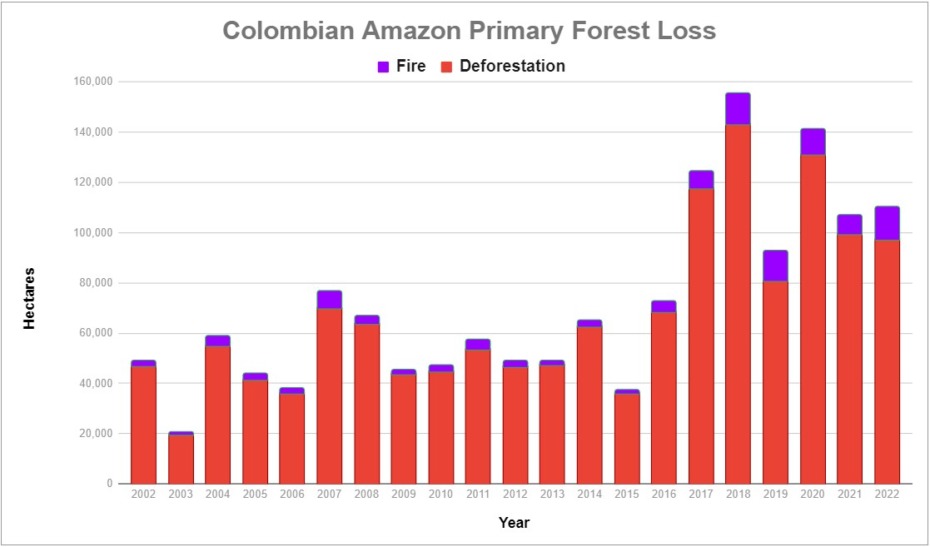
In 2022, the Colombian Amazon lost 97,417 hectares of primary forest to deforestation. Fires directly impacted an additional 12,880 hectares.

Deforestation decreased 2% from 2021, but it was still relatively high (5th highest on record), continuing the trend of elevated forest loss since the FARC peace agreement in 2016.

Fire impact increased from last year and was actually the highest on record, edging out 2018 and 2019.

As described in previous reports (see MAAP #120), the Colombia Base Map shows there continues to be an “arc of deforestation” in the northwest Colombian Amazon (Caqueta, Meta, and Guaviare departments).

This arc impacts numerous Protected Areas (particularly Tinigua and Chiribiquete National Parks) and Indigenous Reserves (particularly Yari-Yaguara II and Nukak Maku).


Ecuadorian Amazon

Ecuador Base Map, 2022. Deforestation and fire hotspots in the Ecuadorian Amazon. Data: UMD/GLAD, ACA/MAAP.

Although accounting for just 1% of total loss across the Amazon, deforestation in the Ecuadorian Amazon was the highest on record in 2022 (18,902 hectares), up a striking 80% since 2021.

There are several deforestation hotspots caused by gold mining (see MAAP #182), oil palm plantation expansion, and small-scale agriculture.


Venezuelan Amazon

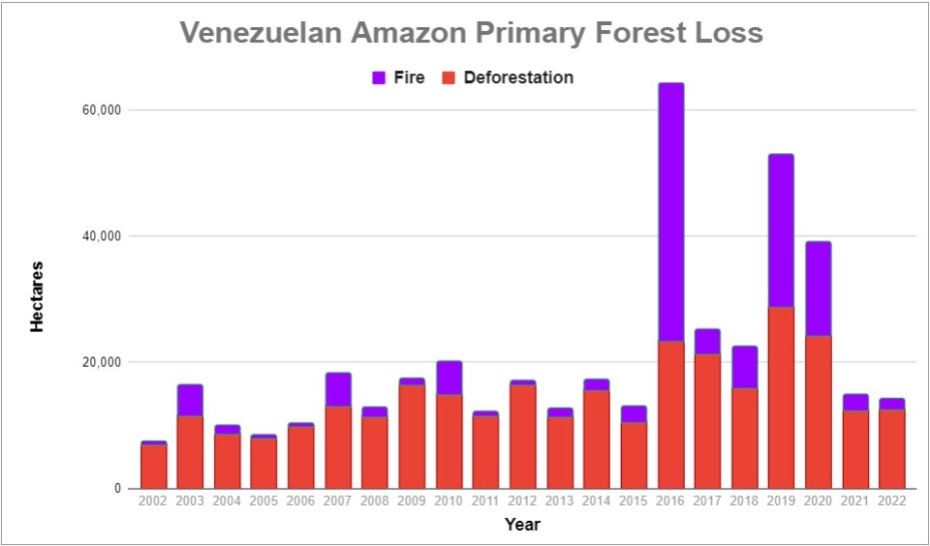
In the Venezuelan Amazon, deforestation was on par with last year (12,584 hectares).

There is a deforestation hotspot caused by gold mining in Yapacana National Park (see MAAP #173, MAAP #156, MAAP #169).

There are also hotspots in the Orinoco Mining Arc caused by mining and agriculture.


Methodology

The analysis was based on 30-meter resolution annual forest loss data produced by the University of Maryland and also presented by Global Forest Watch.

This data was complemented with the Global Forest Loss due to fire dataset that is unique in terms of being consistent across the Amazon (in contrast to country specific estimates) and distinguishes forest loss caused directly by fire (note that virtually all Amazon fires are human-caused). The values included were ‘medium’ and ‘high’ confidence levels (code 3-4).

The remaining forest loss serves as a likely close proxy for deforestation, with the only remaining exception being natural events such as landslides, wind storms, and meandering rivers. The values used to estimate this category was ‘low’ certainty of forest loss due to fire (code 2), and forest loss due to other ‘non-fire’ drivers (code 1).

For the baseline, it was defined to establish areas with >30% tree canopy density in 2000. Importantly, we applied a filter to calculate only primary forest loss by intersecting the forest cover loss data with the additional dataset “primary humid tropical forests” as of 2001 (Turubanova et al 2018). For more details on this part of the methodology, see the Technical Blog from Global Forest Watch (Goldman and Weisse 2019).

Our geographic range for the Amazon is a hybrid designed for maximum inclusion: biogeographic boundary (as defined by RAISG) for all countries, except for Bolivia and Peru, where we use the watershed boundary, and Brazil, where we use the Legal Amazon boundary.

To identify the deforestation hotspots, we conducted a kernel density estimate. This type of analysis calculates the magnitude per unit area of a particular phenomenon, in this case, forest cover loss. We conducted this analysis using the Kernel Density tool from the Spatial Analyst Tool Box of ArcGIS. We used the following parameters:

Search Radius: 15000 layer units (meters)
Kernel Density Function: Quartic kernel function
Cell Size in the map: 200 x 200 meters (4 hectares)
Everything else was left to the default setting.

For the Base Map, we used the following concentration percentages: High: 3-14%; Very High: >14%.

Acknowledgements

We thank colleagues at Global Forest Watch (GFW), an initiative of the World Resources Institute (WRI) for comments and access to data.

This work was supported by Norad (Norwegian Agency for Development Cooperation) and ICFC (International Conservation Fund of Canada).

Citation

Finer M, Mamani N (2023) Amazon Deforestation & Fire Hotspots 2022. MAAP: 187

MAAP #185: Gold Mining Deforestation in the Southern Peruvian Amazon: 2021-2022 Update

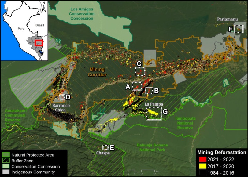
Base Map. Gold Mining Deforestation in the Southern Peruvian Amazon, 2021-2022 update. Zooms indicated by insets A-F. Click on image to enlarge. Data: ACA/MAAP, CINCIA.

Gold mining continues to be one of the main causes of deforestation in the southern Peruvian Amazon, especially in the Madre de Dios region.

Here, we provide a comprehensive look at the most recent (2021-2022) gold mining-related deforestation in the area, combining two important types of data for the first time:

  1. Deforestation within the Mining Corridor, a large area delimited by the Peruvian government to organize and promote mining. Mining activity in this corridor, officially known as the “Small-scale and Artisanal Mining Zone in the department of Madre de Dios,” can be formal, informal, or illegal.1
    j
  2. Deforestation outside the Mining Corridor, which represents our estimate of illegal mining. According to current regulations (Legislative Decree No. 1336), illegal mining occurs in one or more territorial categories such as protected natural areas, indigenous reserves, and natural bodies of water (such as lakes or rivers). Therefore, for this report, the presence of mining-related deforestation in protected natural areas and their buffer zones, as well as indigenous communities, is considered an indicator of illegality. However, it is important to recognize the possibility that some of these findings may be covered by current regulations regarding mining formalization.2 Therefore, it is recommended to consider the findings of illegal deforestation as referential.

These two study areas cover a total of 1.38 million hectares and include all detected mining areas in the southern Peruvian Amazon.

We highlight several important findings (see Base Map and Table 1):

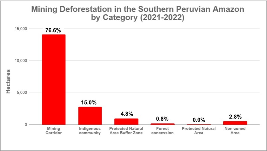
  • Table 1. Data: ACA/MAAP.

    We estimate a total deforestation of 18,421 hectares (45,520 acres) due to gold mining in the southern Peruvian Amazon in the last two years (2021-2022).
    l

  • Of this total, the majority of mining-related deforestation (76.6%, or 14,117 hectares) occurred within the Mining Corridor.
    l
  • The remaining deforestation (23.4%, or 4,304 hectares) took place outside the Mining Corridor. Breaking down this percentage, 15% is found in indigenous communities, 4.8% in buffer zones of protected natural areas, 0.8% in forest concessions, and 2.8% in non-zoned areas.
    j
  • Furthermore, we found that mining within protected natural areas, such as the Tambopata National Reserve and the Amarakaeri Communal Reserve, has been effectively controlled by the Peruvian government through the National Service of Protected Natural Areas (SERNANP).
    j
  • It is important to highlight that mining has stopped in the core of La Pampa (the most critical zone during the years 2014-2018) following Operation Mercury in early 2019 and the subsequent Restoration Plan in 2021.
    j
  • Compared to the years prior to Operation Mercury (2017-2018), there has been an approximate decrease of 4.5% (866 hectares) in mining-related deforestation. Most notably, there has been a major reduction in mining outside the corridor (from 47.7% to 23.4%), and a greater concentration within the corridor (from 52.3 to 76.6%).That is, an apparent major reduction in illegal mining.

Mining Corridor

Our main finding is that the vast majority (76.6%) of gold mining-related deforestation in the southern Peruvian Amazon occurred within the Mining Corridor.

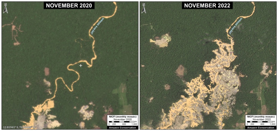
We estimate that the deforestation due to mining is 14,117 hectares within the Mining Corridor in the last two years (2021-2022). Below, we present a series of zooms of some emblematic examples of recent mining-related deforestation in the corridor (Images A-C).

Image A: Mining Corridor

Image B: Mining Corridor

Image C: Mining Corridor

Outside of the Mining Corridor

The remaining deforestation due to mining (23.4%) is located outside the Mining Corridor. Breaking this down, 15% (2,769 hectares) occurred within indigenous territories, 4.8% (876 hectares) in buffer zones of protected areas, 0.8% (141 hectares) in forest concessions (for Brazil nuts), and 2.8% (517 hectares) in non-zoned areas during the last two years.

Regarding indigenous communities, the most affected were Barranco Chico (816 hectares) and San José de Karene (602 hectares), followed by Tres Islas (482 hectares), San Jacinto (177 hectares), Kotsimba (174 hectares), Puerto Luz (171 hectares), Boca Inambari (140 hectares), Shiringayoc (126 hectares), Arazaire (57 hectares), and El Pilar (23 hectares).

Regarding the buffer zones of protected areas, the most affected were the buffer zones of the Tambopata National Reserve, the Bahuaja Sonene National Park, and the Amarakaeri Communal Reserve. On the other hand, it has been found that mining within the actual protected areas, such as the Tambopata National Reserve and the Amarakaeri Communal Reserve, has been effectively controlled by the Peruvian government through the National Service of Natural Protected Areas (SERNANP).

Regarding forest concessions, deforestation due to mining was identified in 141 hectares within Brazil nut concessions in the Pariamanu and Pariamarca river basins.

Next, we continue with a series of zooms showing some emblematic examples of recent deforestation due to mining in the following prohibited areas: indigenous communities (Barranco Chico, Image D), buffer zone of the Bahuaja Sonene National Park (Chaspa, Image E), and Brazil nut concessions (Pariamanu, Image F).

We also present an important area in the buffer zone of the Tambopata National Reserve known as La Pampa (Image G). La Pampa was the epicenter of destructive deforestation due to gold mining between 2014 and 2018. We show that after Operation Mercury, which began in early 2019, the expansion of gold mining in La Pampa was essentially halted.

Image D: Barranco Chico (Indigenous Community)

Image E: Chaspa (Buffer Zone of Bahuaja Sonene National Park)

Image F: Pariamanu (Brazil Nut Concession)

Image G: La Pampa (Buffer Zone of Tambopata National Reserve)

Annex

We show a version of the Basemap without the zoom insets.

Base Map (without insets). Deforestation by Gold Mining in the Southern Peruvian Amazon, with Update 2021-22. Click image to enlarge. Data: ACA/MAAP, CINCIA.

Notes

1The Mining Corridor, designated by Legislative Decree No. 1100 as the “Zone for small-scale and artisanal mining in the department of Madre de Dios,” categorizes mining activities as follows:

  • Formal: Completed formalization process with approved environmental and operational permits.
  • Informal: In the process of formalization; Operates only in authorized extraction areas, uses permitted machinery, and is considered an administrative offense, not a crime.
  • Illegal: Operates in prohibited areas such as bodies of water (e.g., rivers or lakes), uses prohibited machinery, is considered a criminal offense, and is punishable by imprisonment.

2 Due to the possibility that these activities could be existing operations prior to the declaration of Natural Protected Areas and their buffer zones.

3 The data for 2017-2018 were obtained from the Amazonian Scientific Innovation Center – CINCIA.

Methodology

Mining Corridor

We used LandTrendR, a temporal segmentation algorithm that identifies changes in pixel values over time, to detect forest loss within the Mining Corridor in 2021 and 2022 using the Google Earth Engine platform. It is important to note that this method was originally designed for Landsat images with moderate resolution (30 meters)1, but we adapted it for higher spatial resolution NICFI-Planet monthly mosaics (4.7 meters).2

Additionally, we created a baseline for the period 2016-2020 to eliminate old deforested areas (prior to 2021) due to rapid changes in the natural regrowth process.

Finally, we manually separated forest loss due to mining and other causes in 2021 and 2022 to specifically report on direct impacts related to mining. For this part of the analysis, we used various resources to aid the manual process, such as radar image alerts (RAMI) from the SERVIR Amazonia program, historical data from CINCIA from 1985 to 2020, forest loss data from the Peruvian government (National Forest Conservation Program for Climate Change Mitigation), and the University of Maryland.

  1. Kennedy, R.E., Yang, Z., Gorelick, N., Braaten, J., Cavalcante, L., Cohen, W.B., Healey, S. (2018). Implementation of the LandTrendr Algorithm on Google Earth Engine. Remote Sensing. 10, 691.
  2.  Erik Lindquist, FAO, 2021

Outside the Mining Corridor

These places were identified as the main active fronts of deforestation due to gold mining, based on historical data from the Amazon Scientific Innovation Center – CINCIA and automatic alerts of forest loss generated by both the University of Maryland (GLAD alerts) and the Peruvian government platform (PNCBMCC-Geobosques).

The analysis combines the LandTrendr method (described earlier) with a photo interpretation based on high-resolution satellite images from Planet (3 meters). In each of the sites, we have detected, identified, and analyzed deforestation due to gold mining between 2021 and 2022. For areas with overlap between native communities and buffer zones, priority was given to the areas of the native communities.

Acknowledgements

We thank S. Novoa, C. Zavala, O. Liao, K. Nielsen, S. Otoya, and C. Ipenza for their valuable contributions and comments to this report, and R. McMullen for translation. We also thank C. Ascorra and M. Pillaca from the Amazon Scientific Innovation Center – CINCIA for providing us with historical mining data from 1985 to 2021.

This report was prepared with the technical support of USAID through the Prevent Project. Prevent (Proyecto Prevenir in Spanish) works with the Government of Peru, civil society, and the private sector to prevent and combat environmental crimes for the conservation of the Peruvian Amazon, particularly in the regions of Loreto, Madre de Dios, and Ucayali.

Disclaimer: This publication is made possible by the generous support of the American people through USAID. The contents are the sole responsibility of the authors and do not necessarily reflect the views of USAID or the United States Government.


Citation

Finer M, Mamani N (2023) Gold Mining Deforestation in the Southern Peruvian Amazon: 2021-2022 Update. MAAP: 185.