MAAP #149: Mennonite Colonies Continue Major Deforestation in Peruvian Amazon

Recent deforestation associated with the newest Mennonite colony “Padre Marquez”. Data: Planet

The Mennonites, a religious group often associated with agricultural activity, have become one of the major deforestation drivers in the Peruvian Amazon.

In October 2020, we reported the deforestation of over 3,400 hectares across three new colonies established.

Here, we show that in 2021 the Mennonites have established a fourth colony (over 400 hectares) and continued expansion of the first three colonies.

In total, we have now documented the deforestation of 3,968 hectares (9,805 acres) across four new colonies established in the Peruvian Amazon since 2017, making it the new leading cause of large-scale deforestation in Peru.

Moreover, there are strong indications that much of this deforestation is illegal (see MAAP #127).

Below, we present the following:

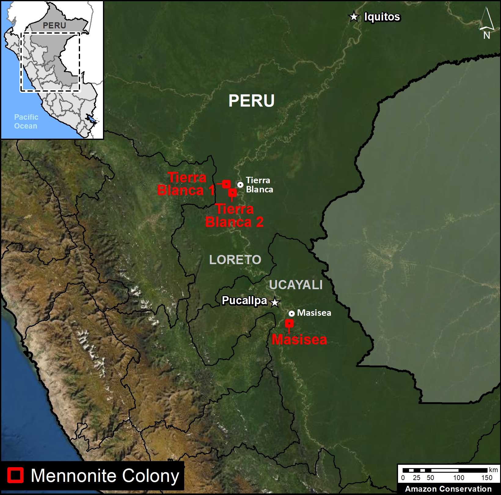
  • An updated Base Map showing the location of the four new Mennonite colonies in the Peruvian Amazon.
    p
  • A series of satellite images showing the most recent deforestation in the newest colony (referred to here as “Padre Marquez”).
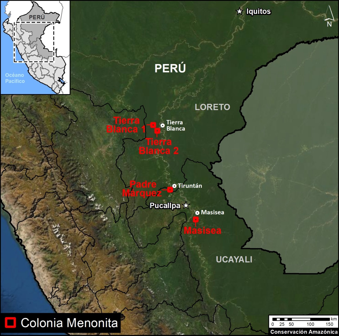
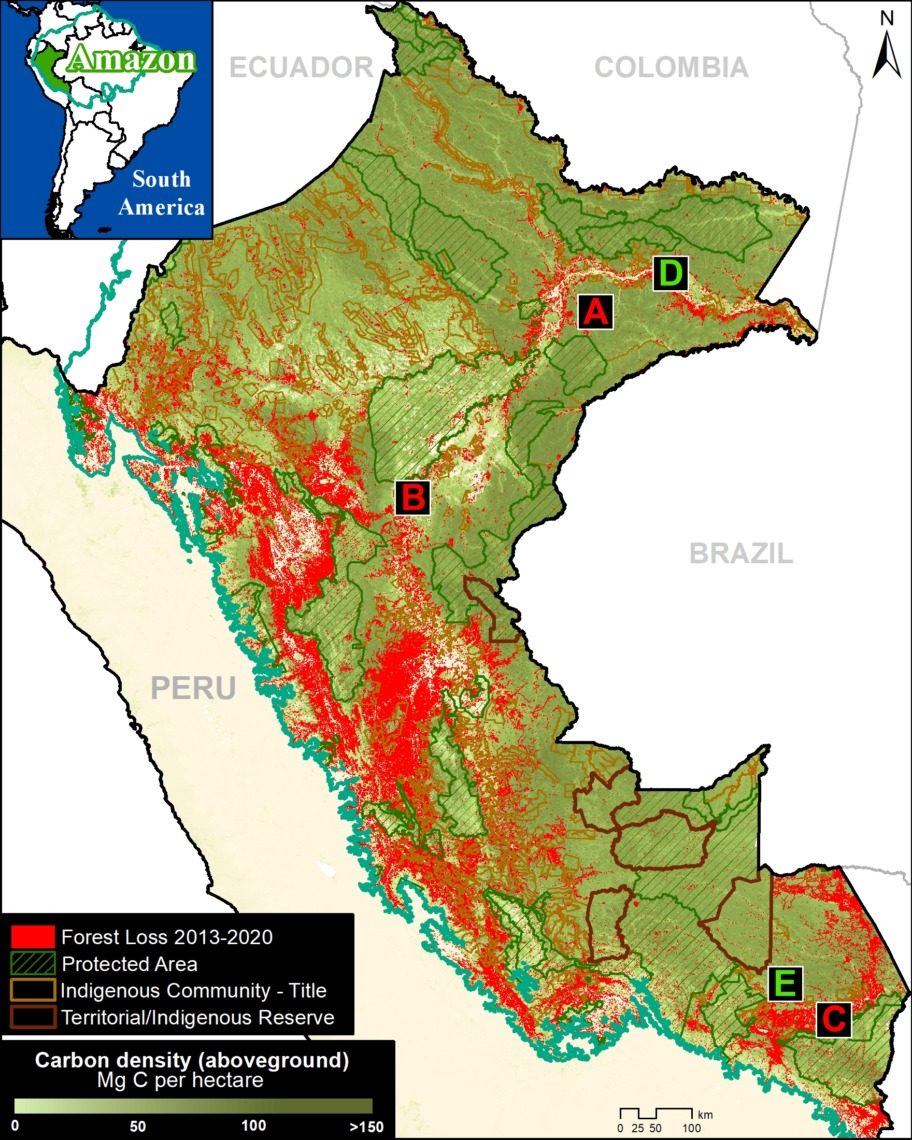
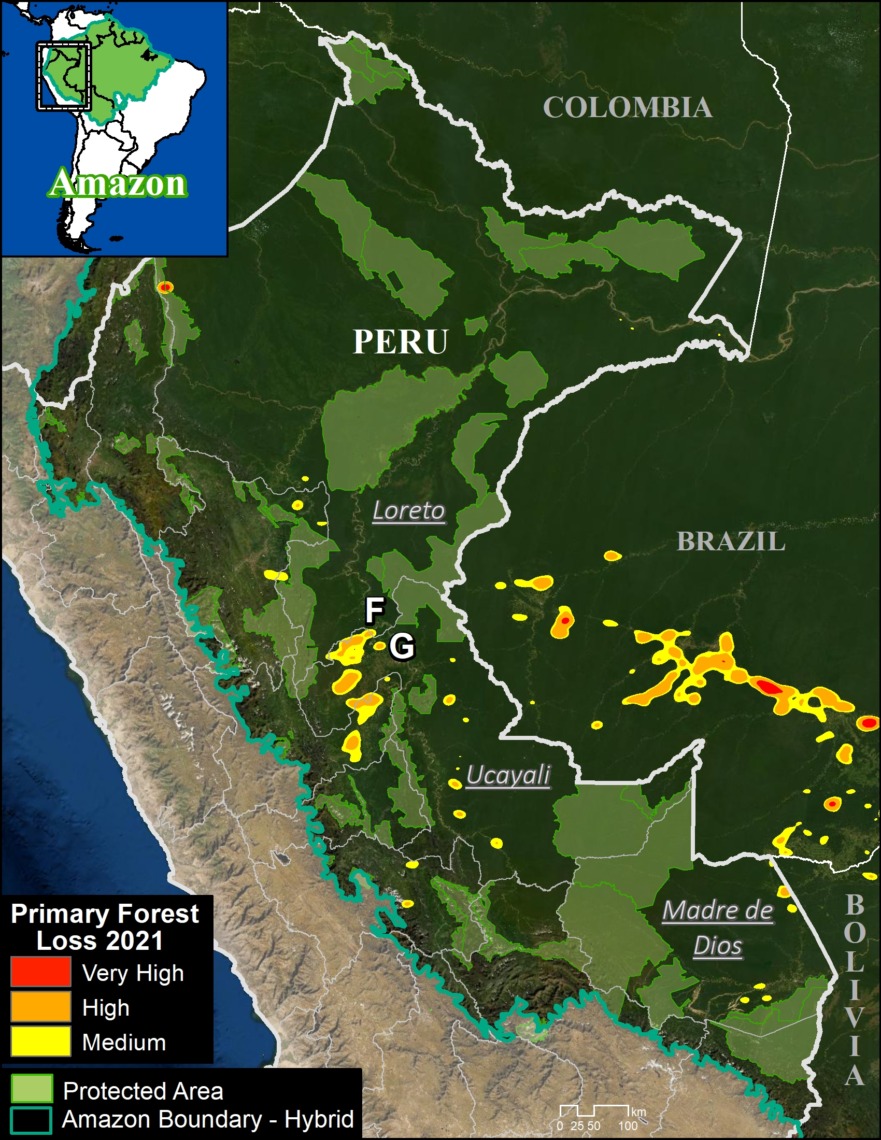
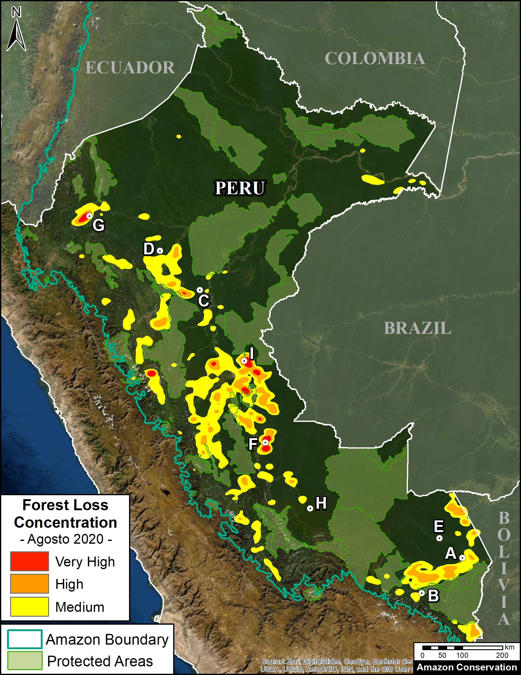
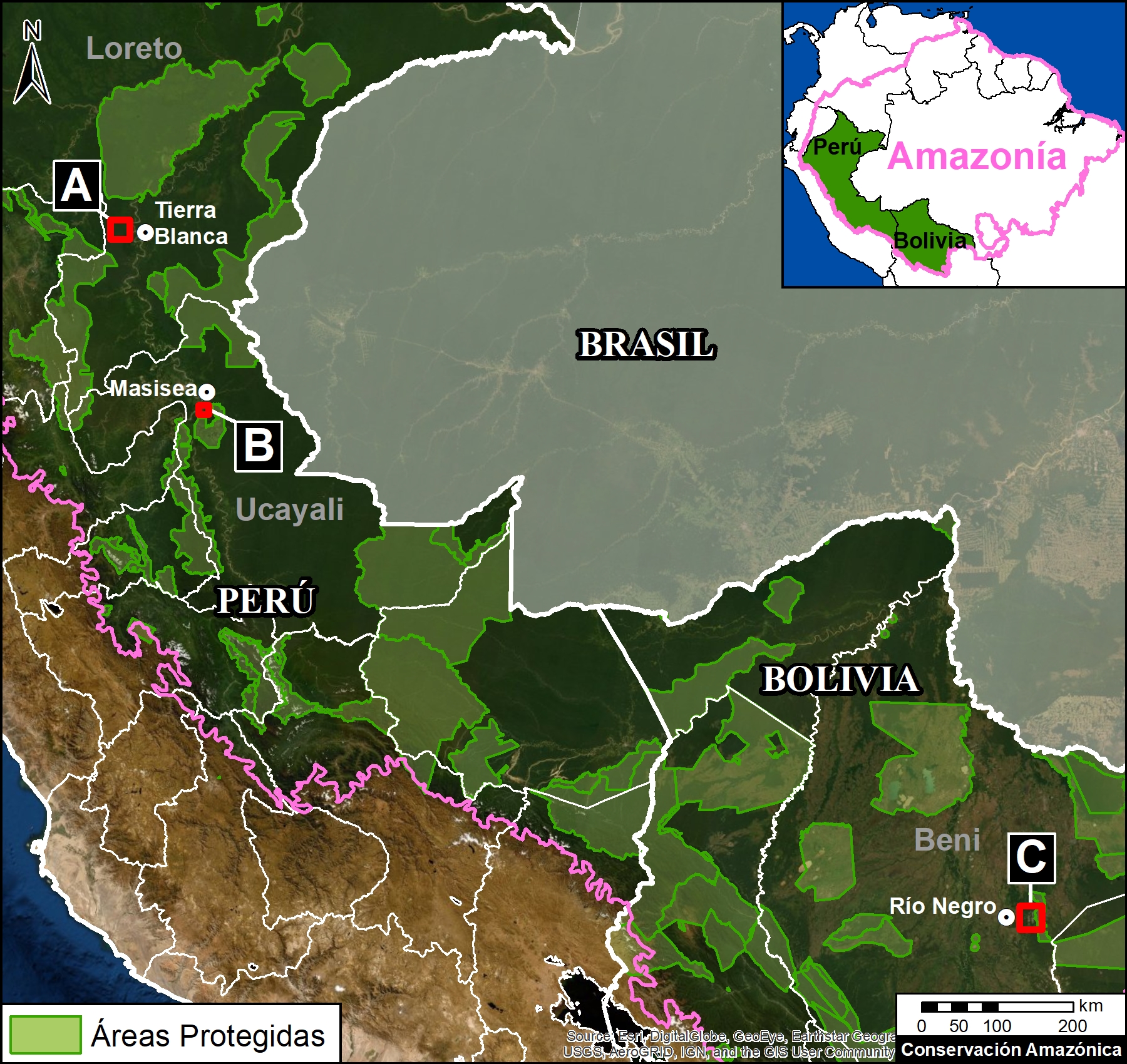
Updated Base Map showing the location of the four major new Mennonite Colonies in the Peruvian Amazon. Data: MAAP.

Base Map

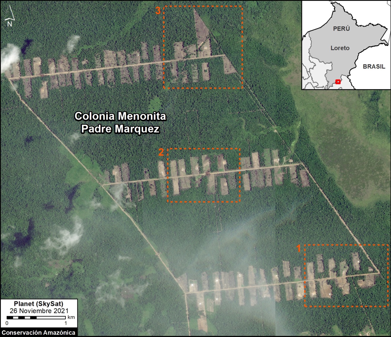
The Base Map shows the location of the four major Mennonite colonies in the Peruvian Amazon.

The newest colony is referred to here as “Padre Marquez,” named for a nearby town. Note that it is located about halfway between the other colonies (Tierra Blanca to the north and Masisea to the south.

Of the total deforestation (3,968 hectares):

  • 66% (2,628 ha) is in the Tierra Blanca colonies in Loreto;
  • 23% (918 ha) is in Masisea colony in Ucayali;
  • 11% (421) is in the new Padre Marquez colony along the Ucayali/Loreto border.
    k
  • 12% occurred in 2021 (495 ha). In addition to the establishment of Padre Marquez, we also detected expansion in the Tierra Blanca and Masisea colonies.
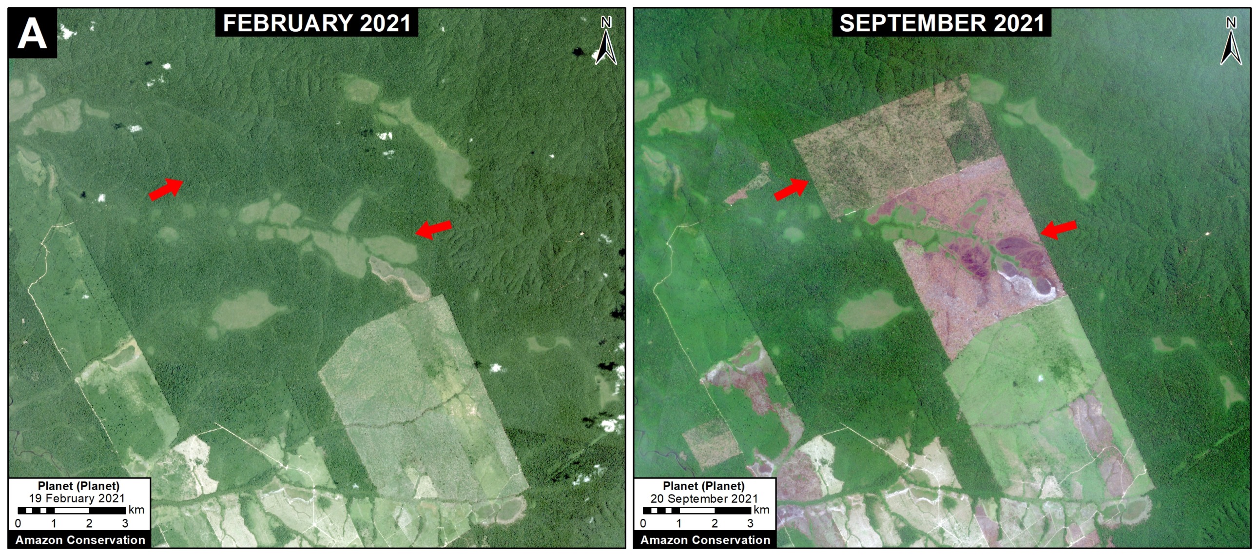
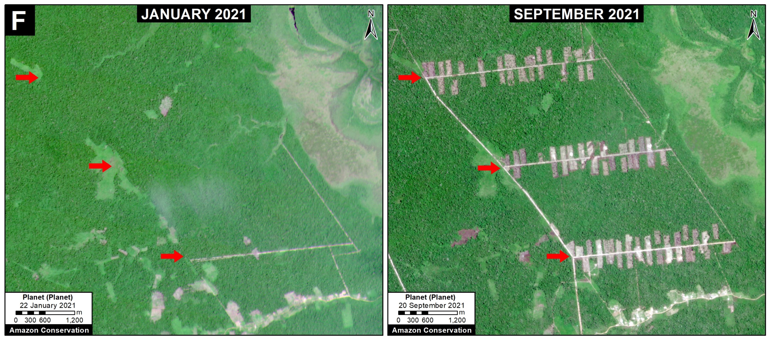
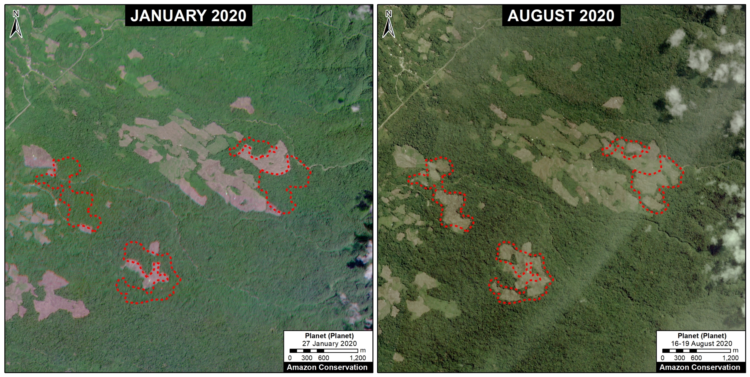
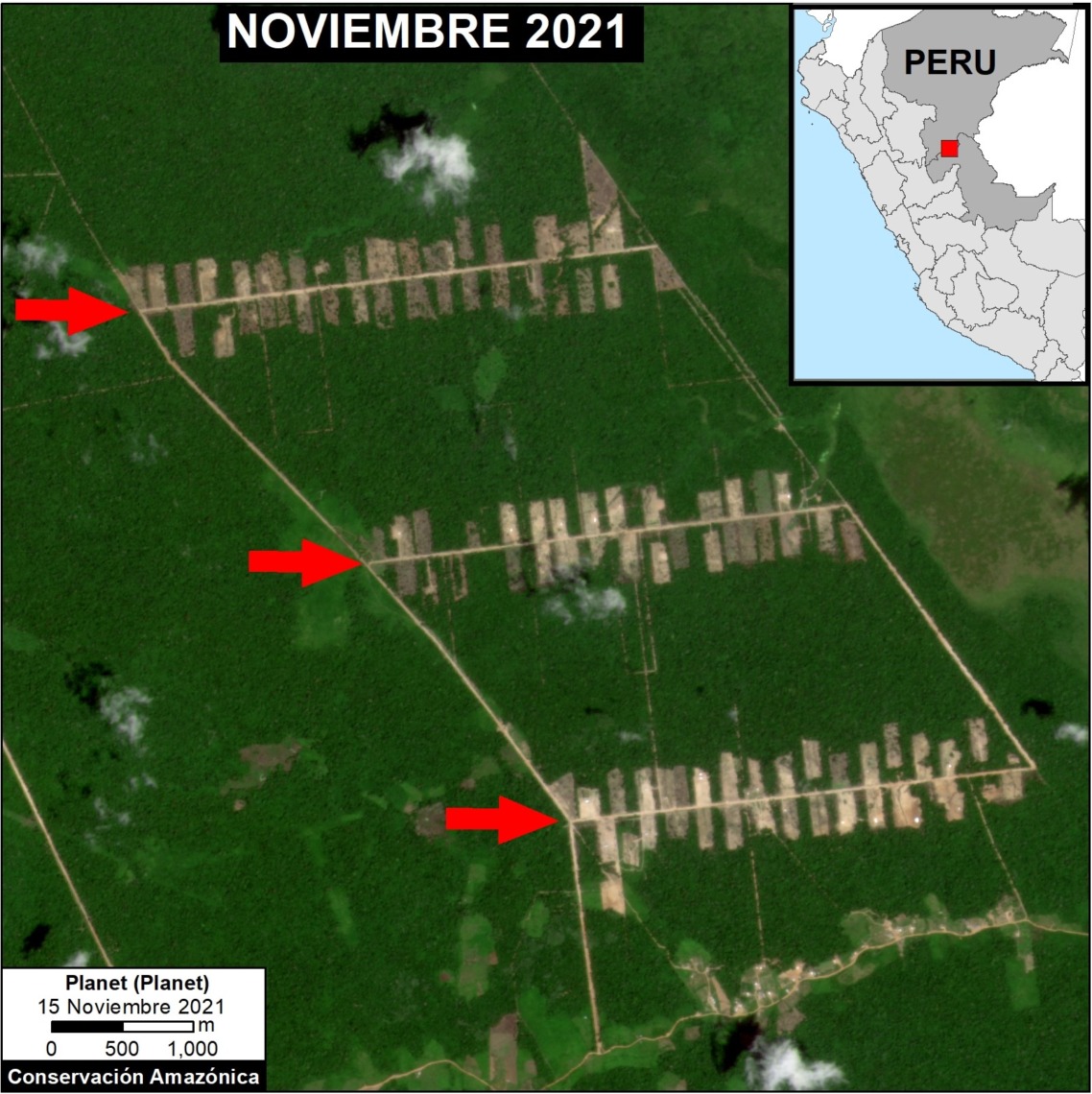
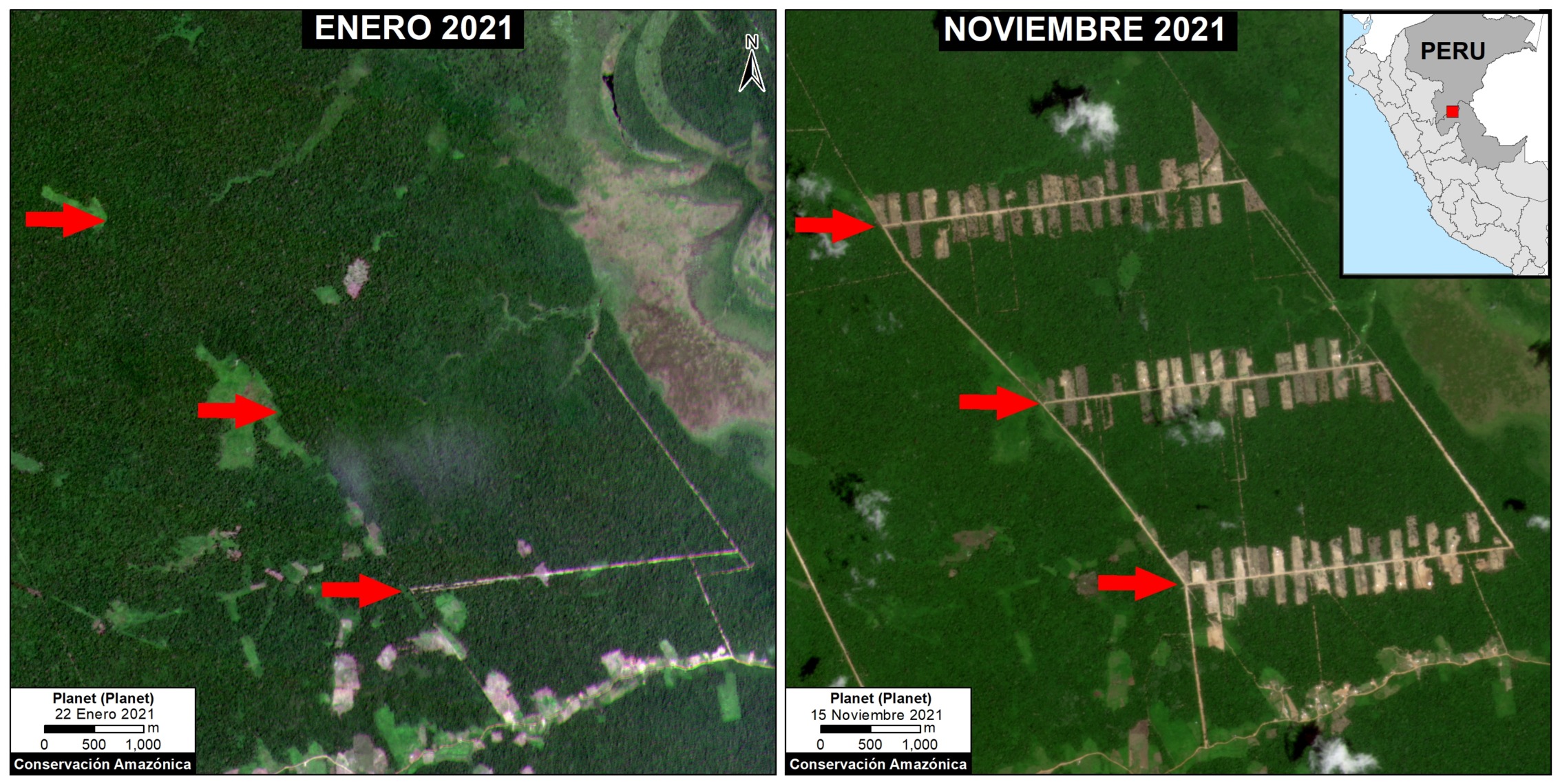
Deforestation 2021

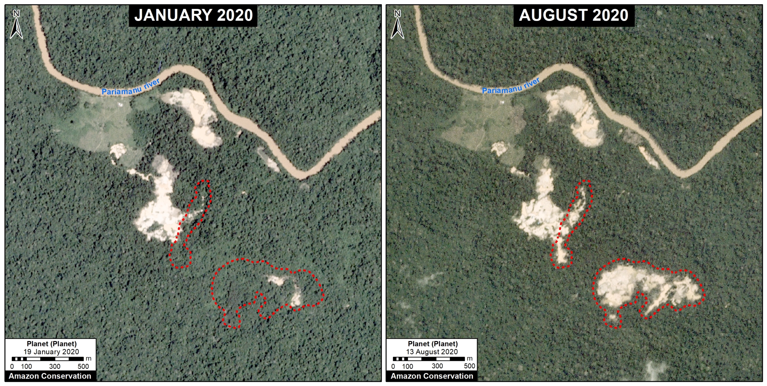
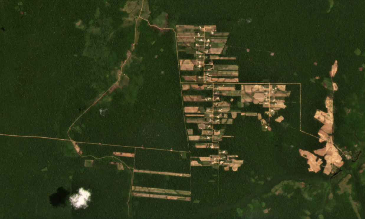
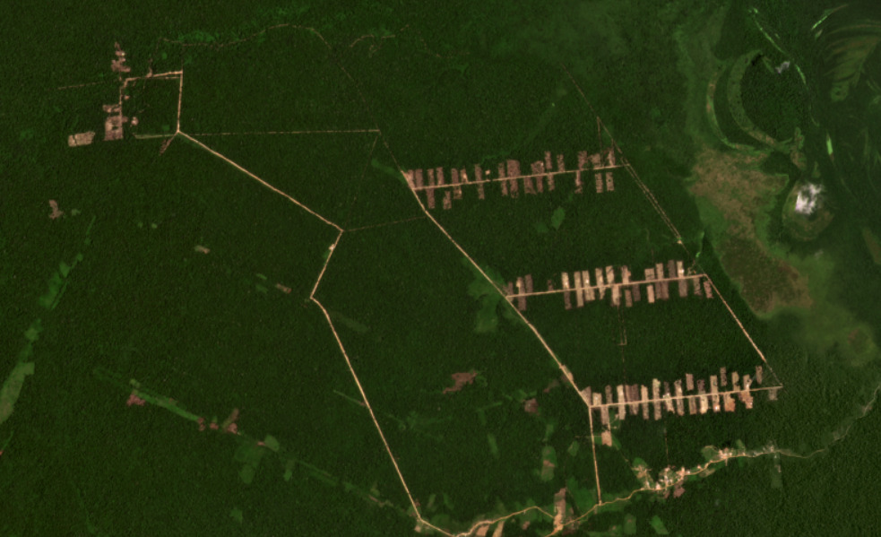
The following image shows the large-scale deforestation of 366 hectares between January (left panel) and November (right panel) 2021 associated with the main section of the new Padre Marquez colony. The red arrows serve as reference points between the two panels. Click to enlarge.

Deforestation between January (left panel) and November 2021 (right panel), associated with the new Padre Marquez colony. Data: Planet, MAAP. Click to enlarge.

Satellite Images of Each Mennonite Colony
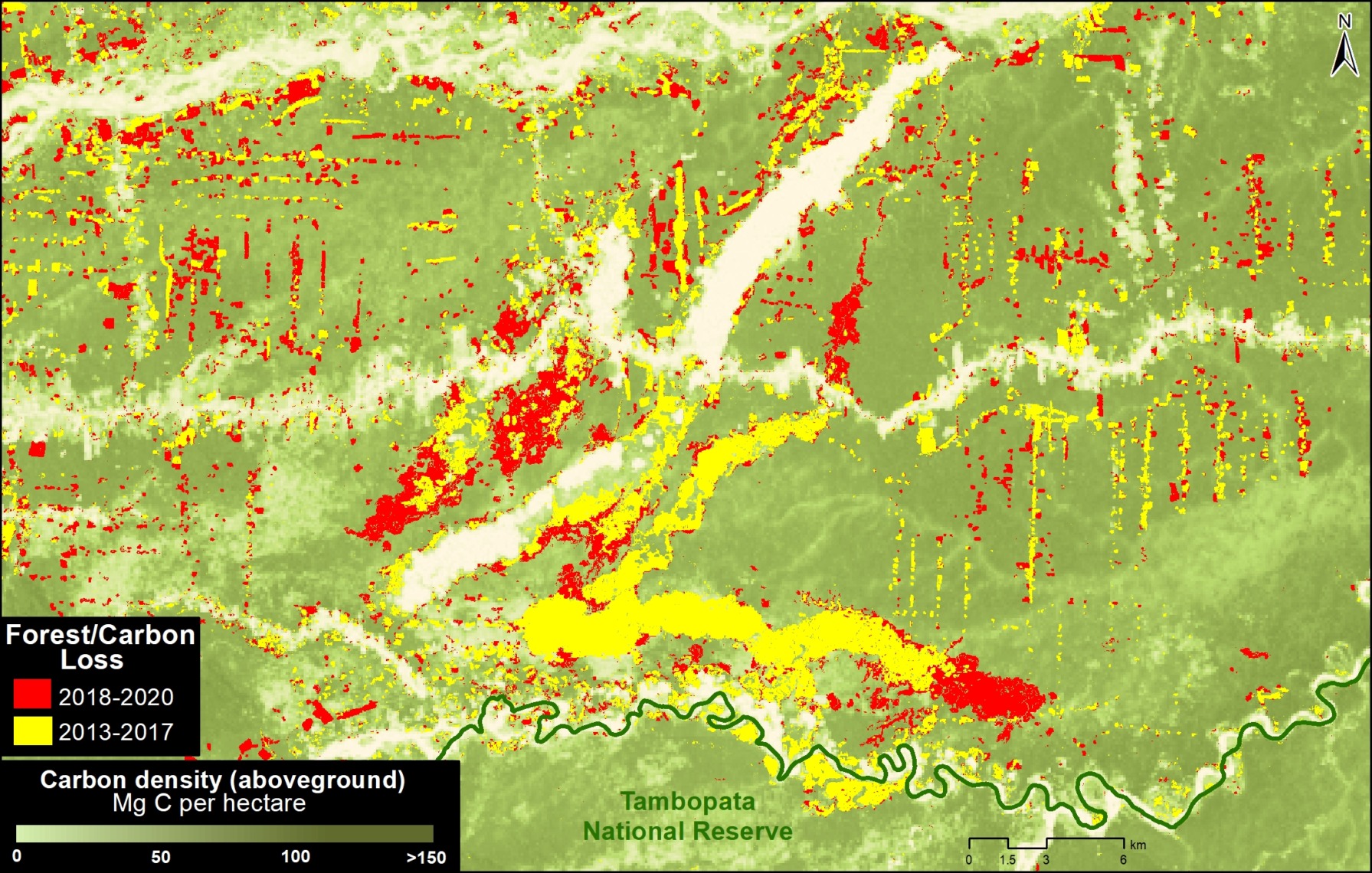
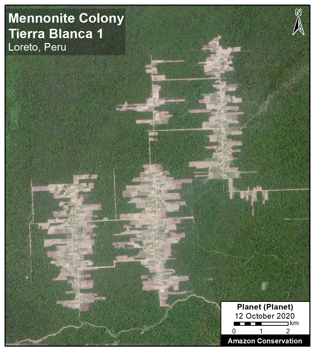
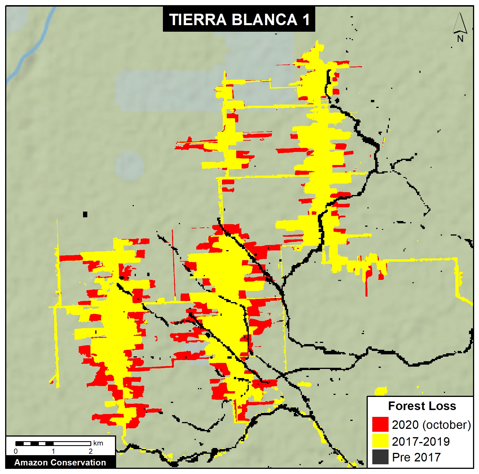
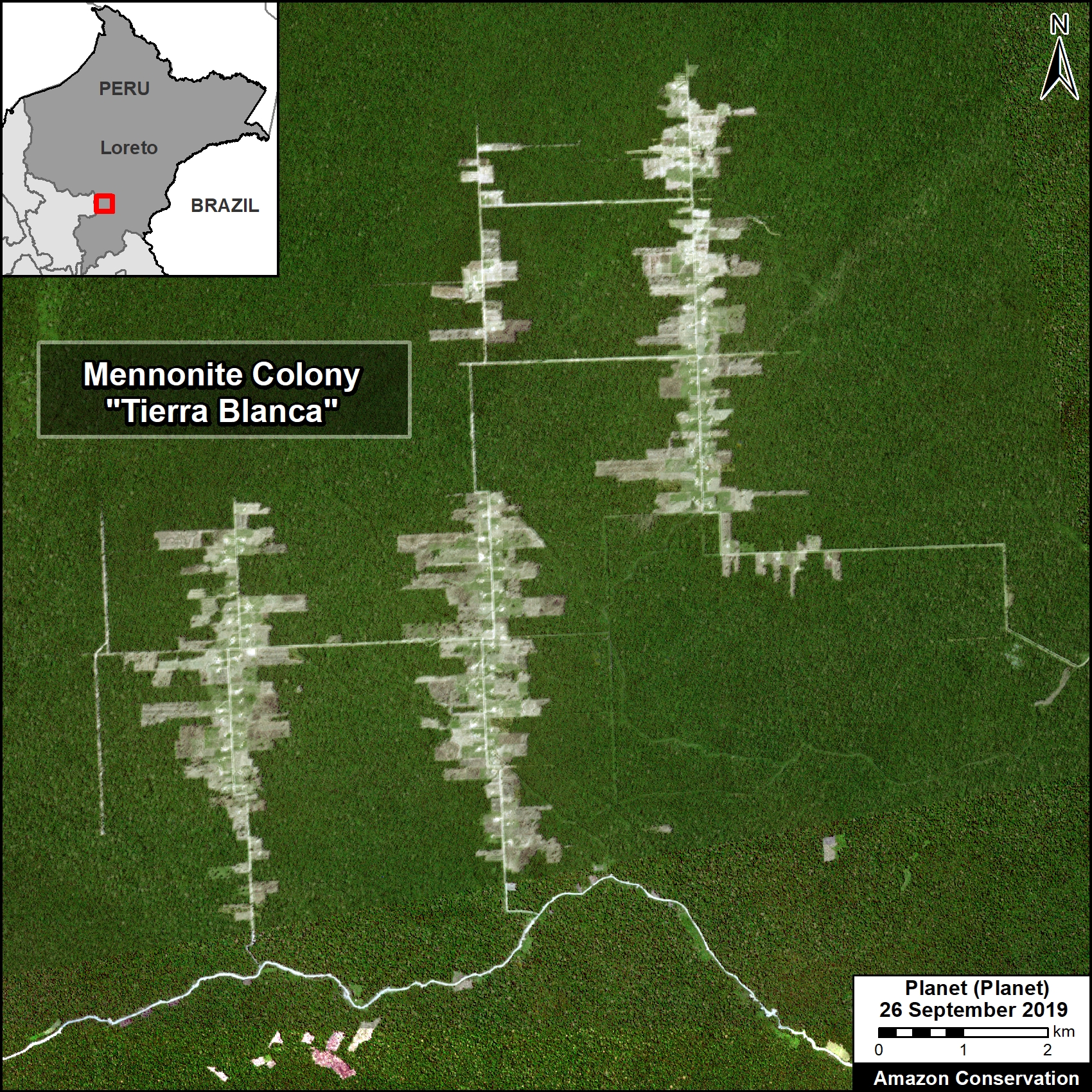
Tierra Blanca 1

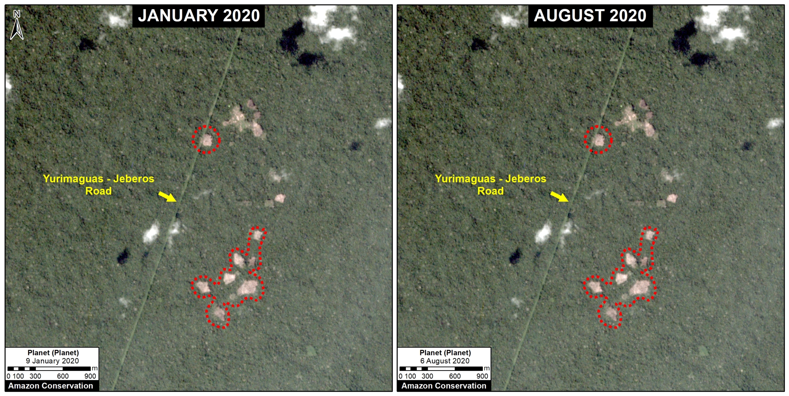
The following image shows the deforestation of 2,200 hectares (5,436 acres) since 2017 in the Tierra Blanca 1 colony (Loreto region). In 2021, this deforestation mostly stopped (only 8 ha).

Tierra Blanca 2

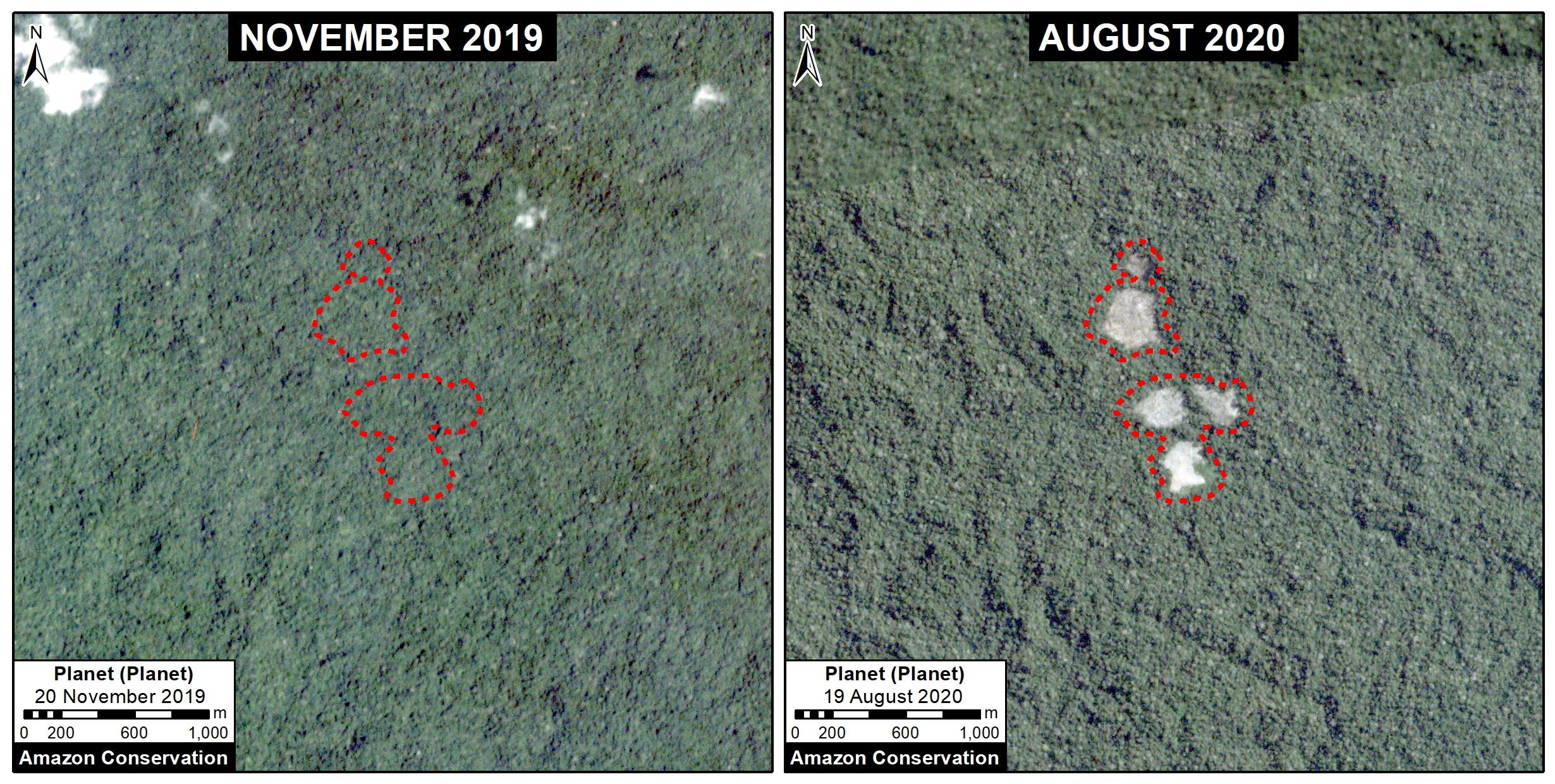
The following image shows the additional deforestation of 428 hectares (1,058 acres) in the nearby Tierra Blanca s colony (Loreto region). In 2021, this deforestation also mostly stopped (15 ha).
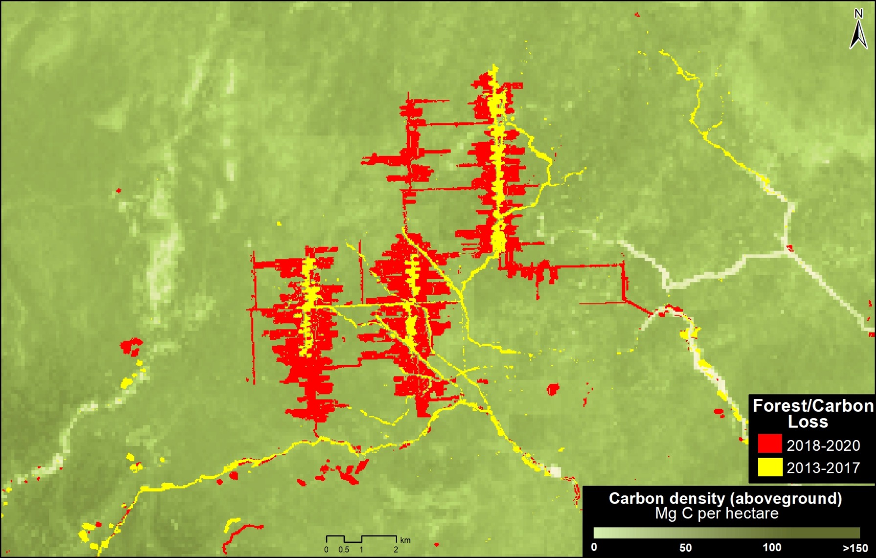
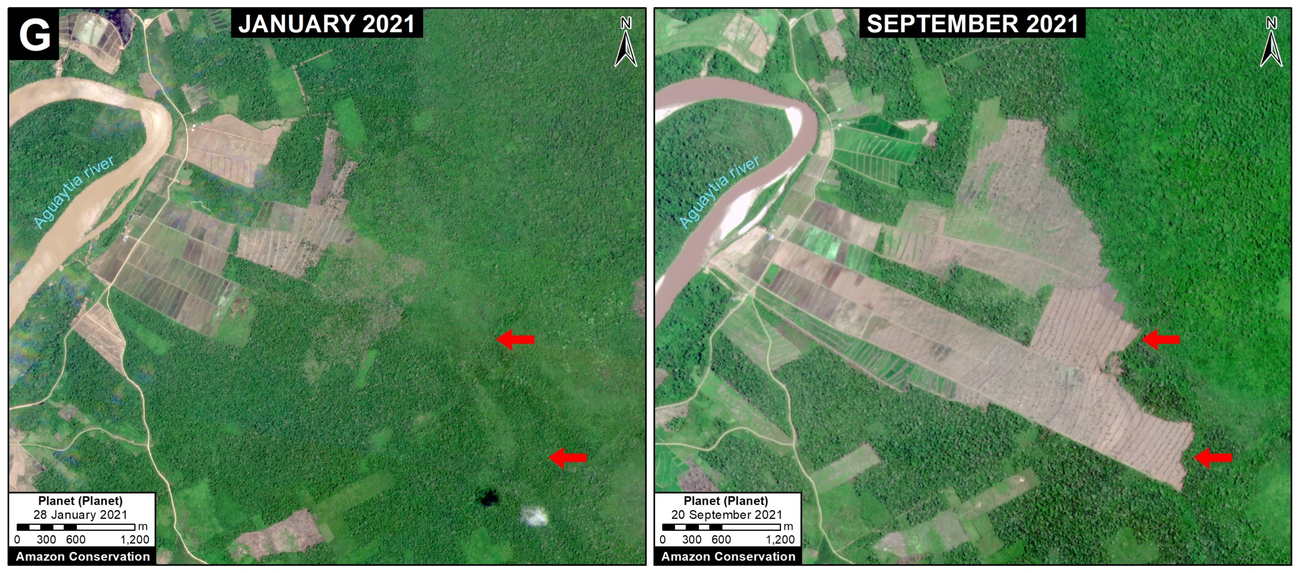
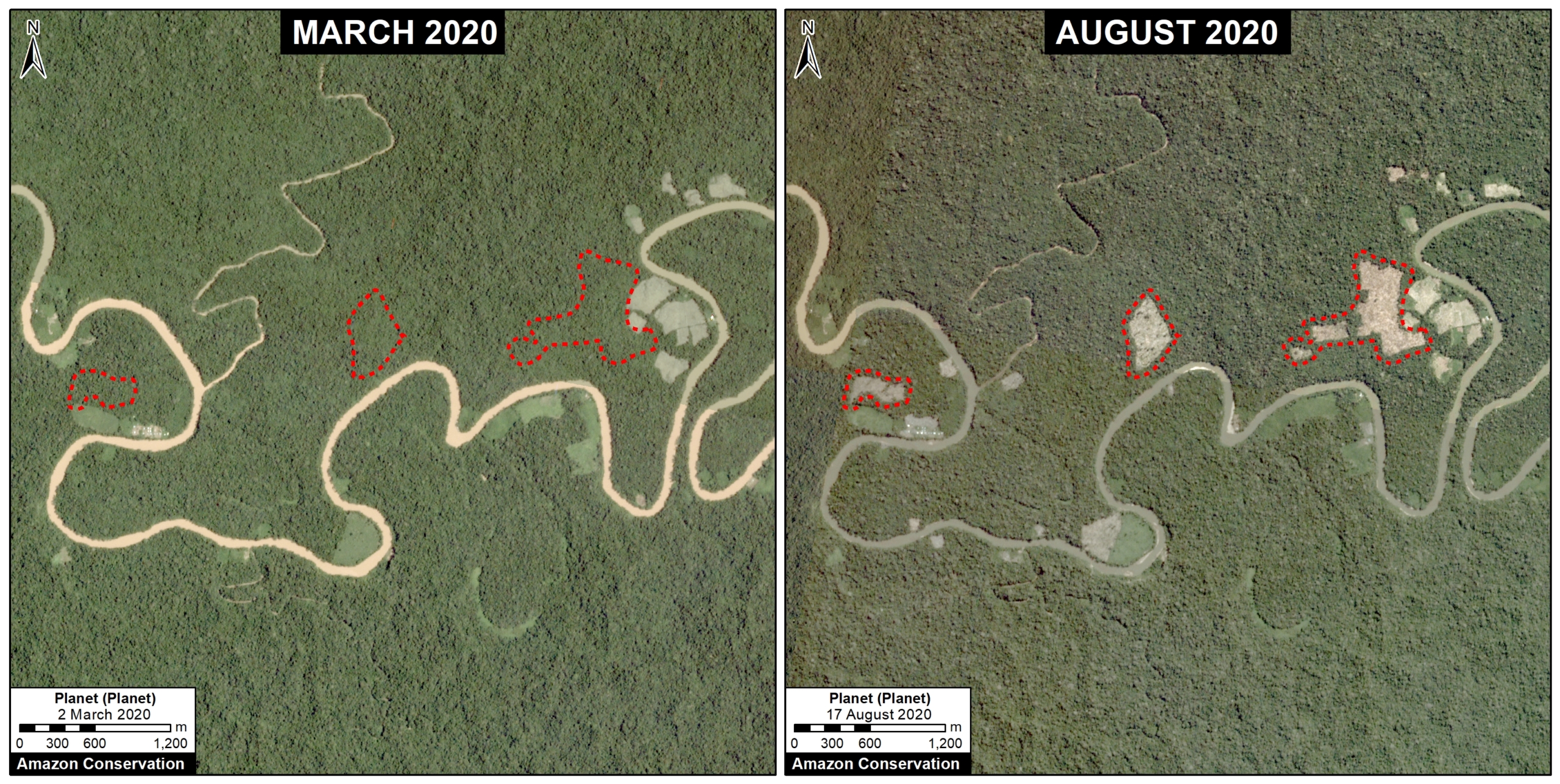
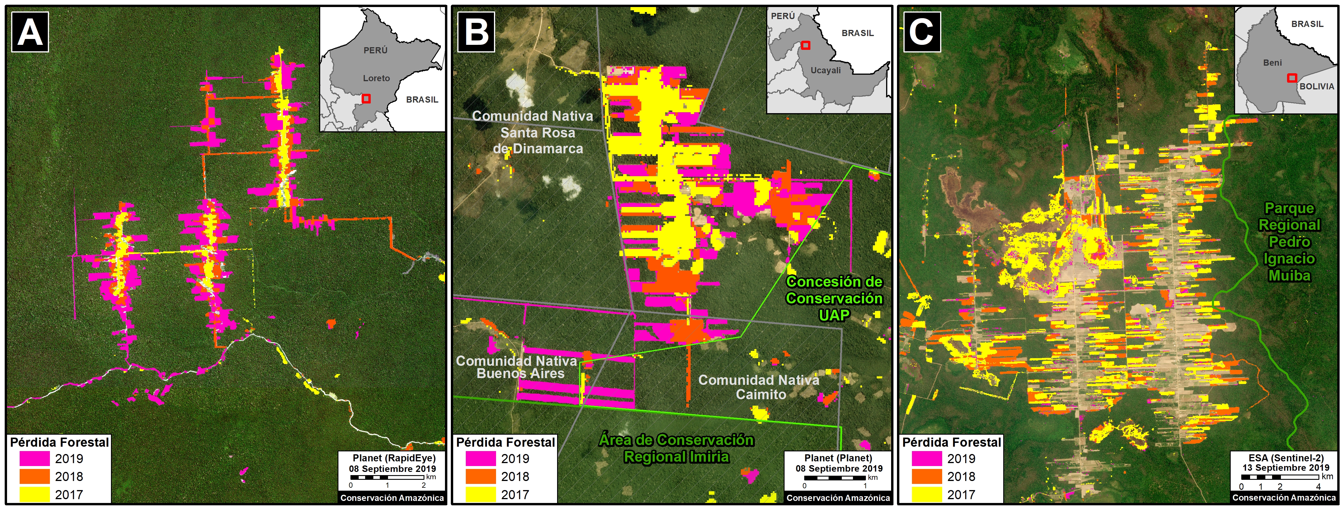
Masisea

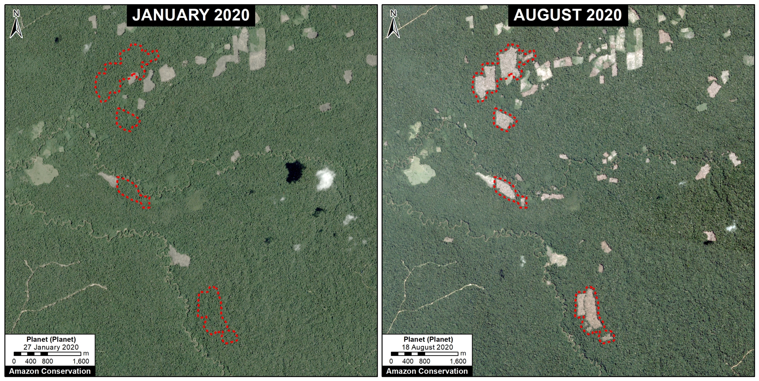
The following image shows the deforestation of 918 hectares (2,268 acres) in the Masisea colony (Ucayali region). In 2021, there was a major expansion to the east (with 47 ha of new deforestation).
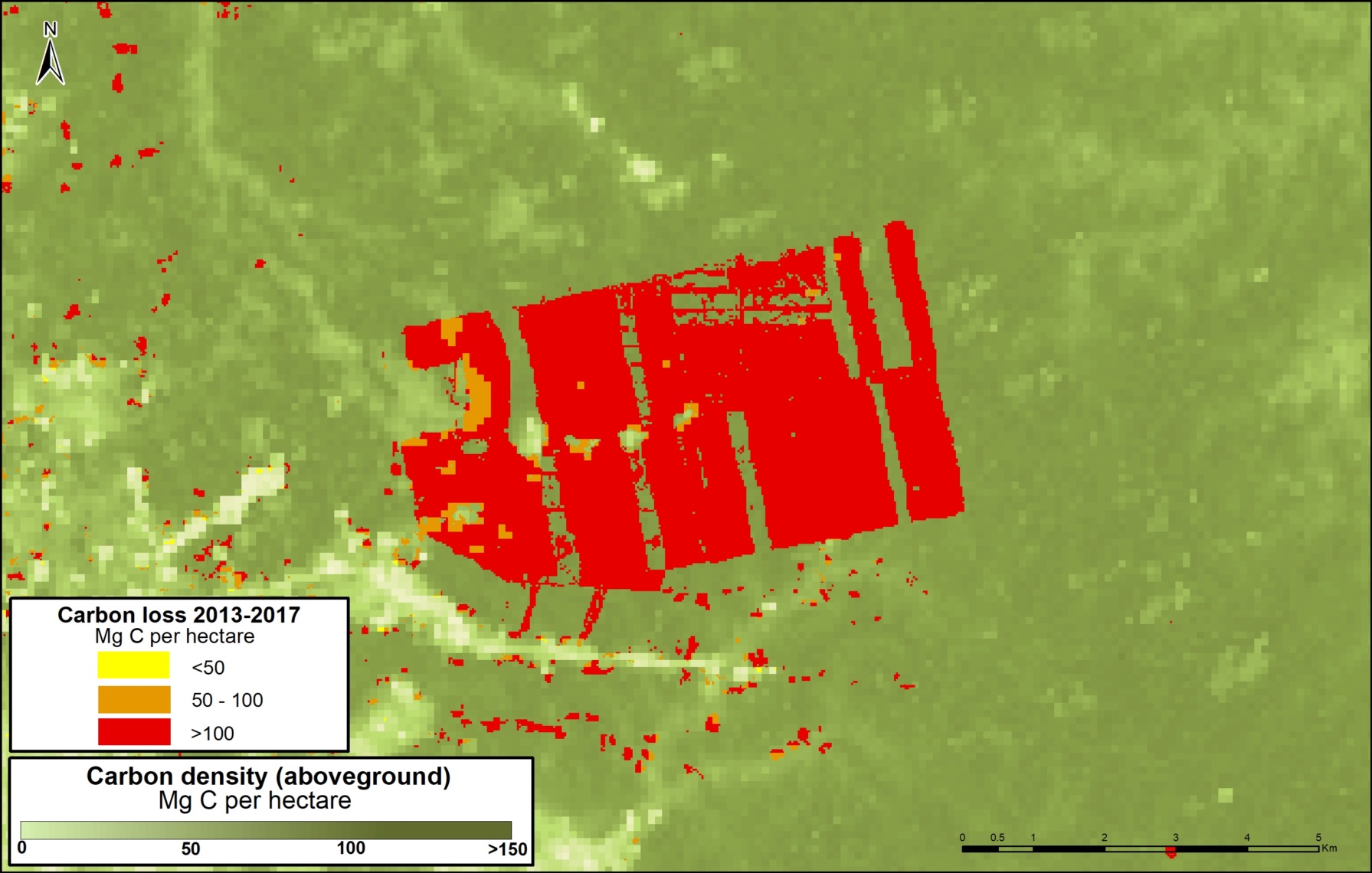
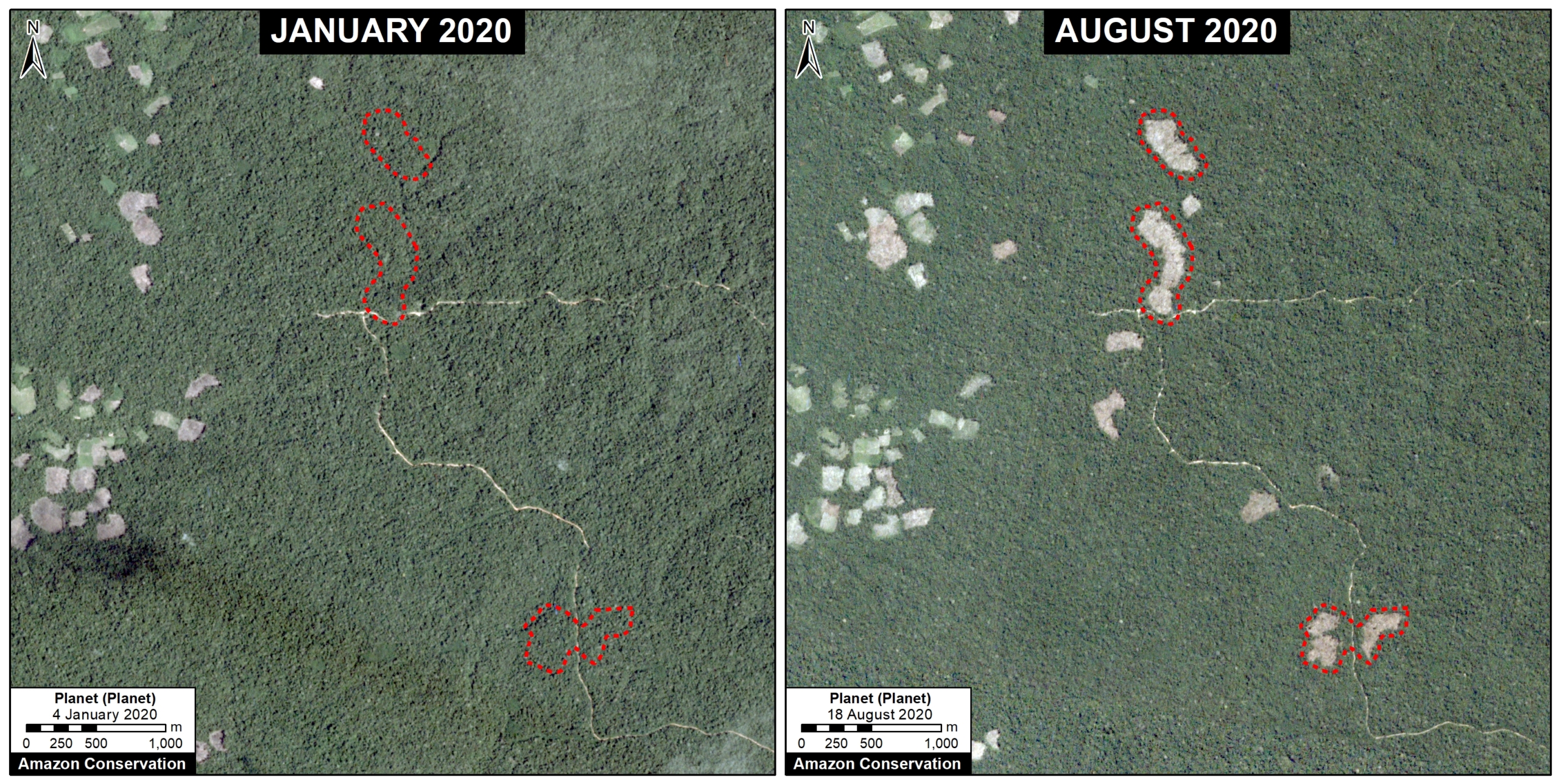
Padre Marquez

The following image shows the deforestation of 421 hectares (1,040 acres) in the Padre Marquez colony (Ucayali region), all of which occured in 2021.

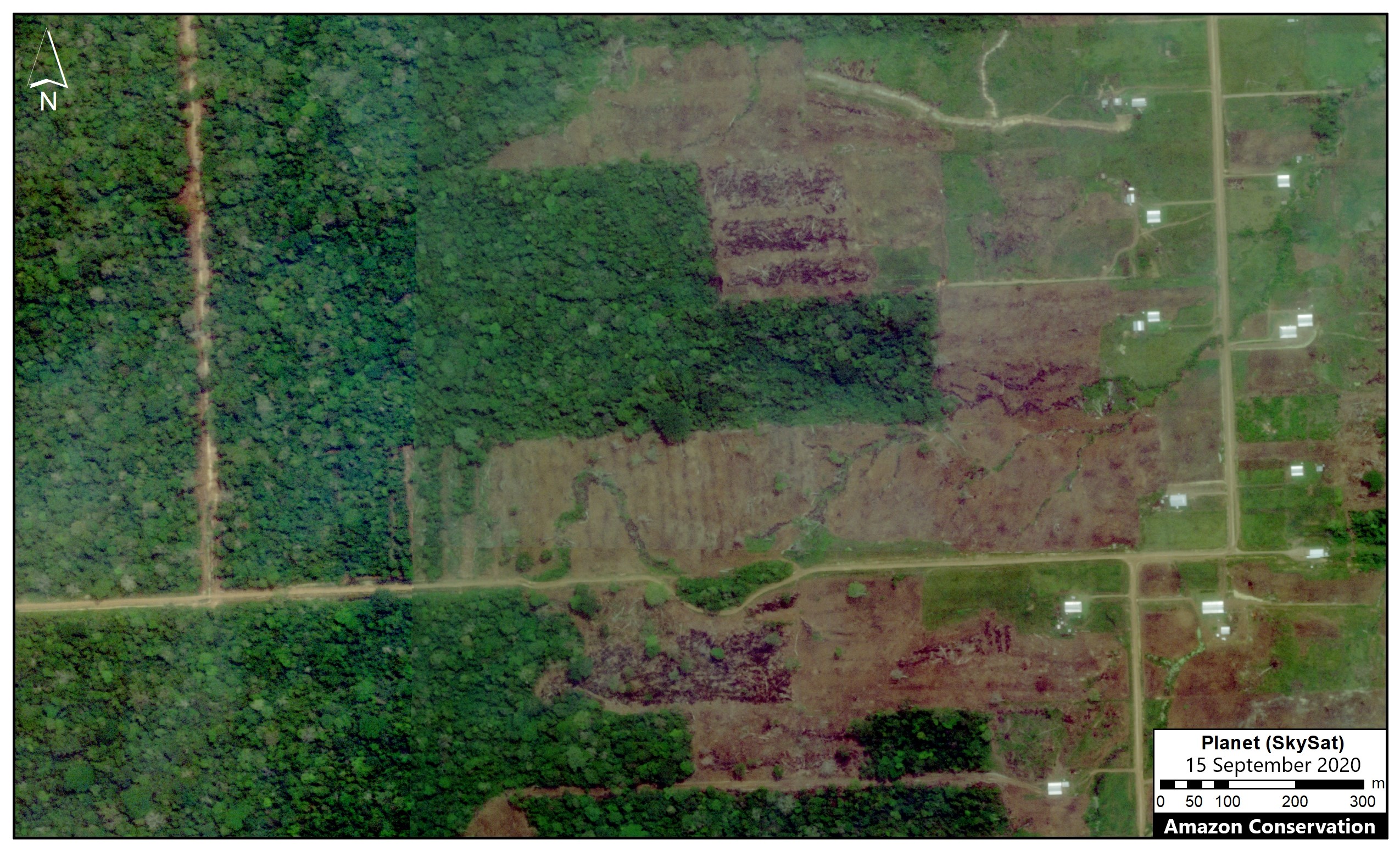
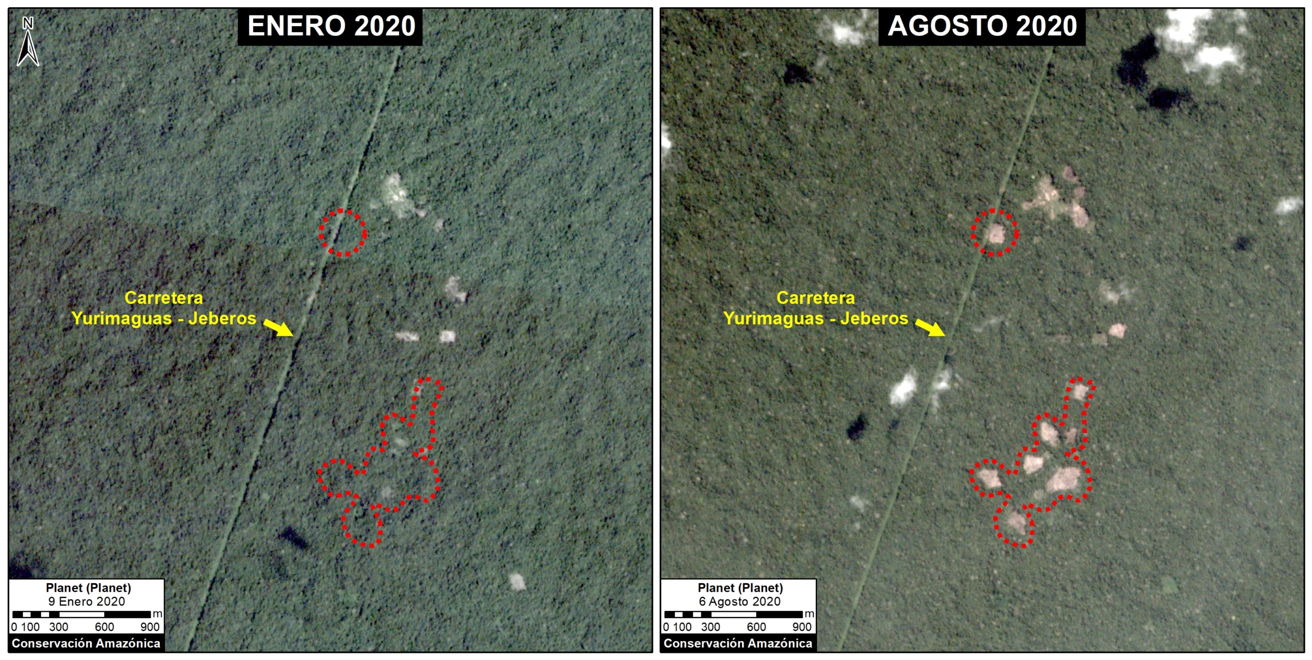
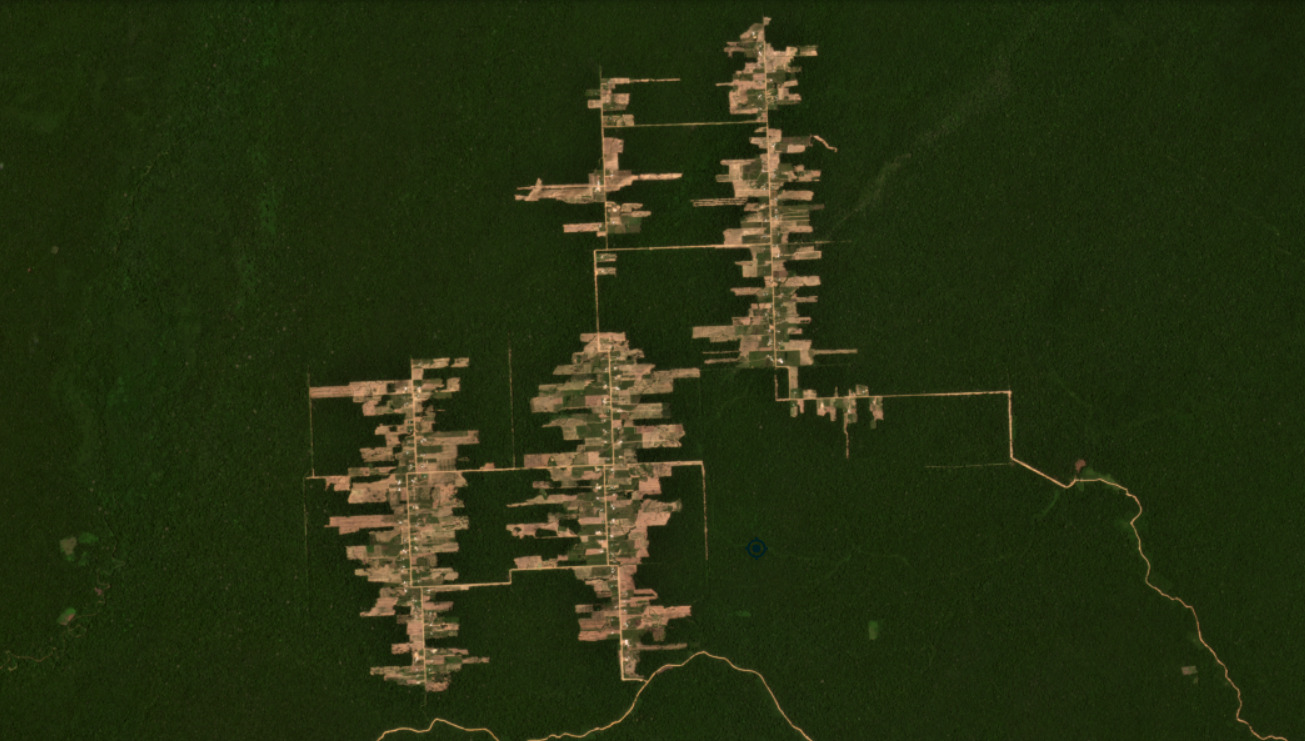
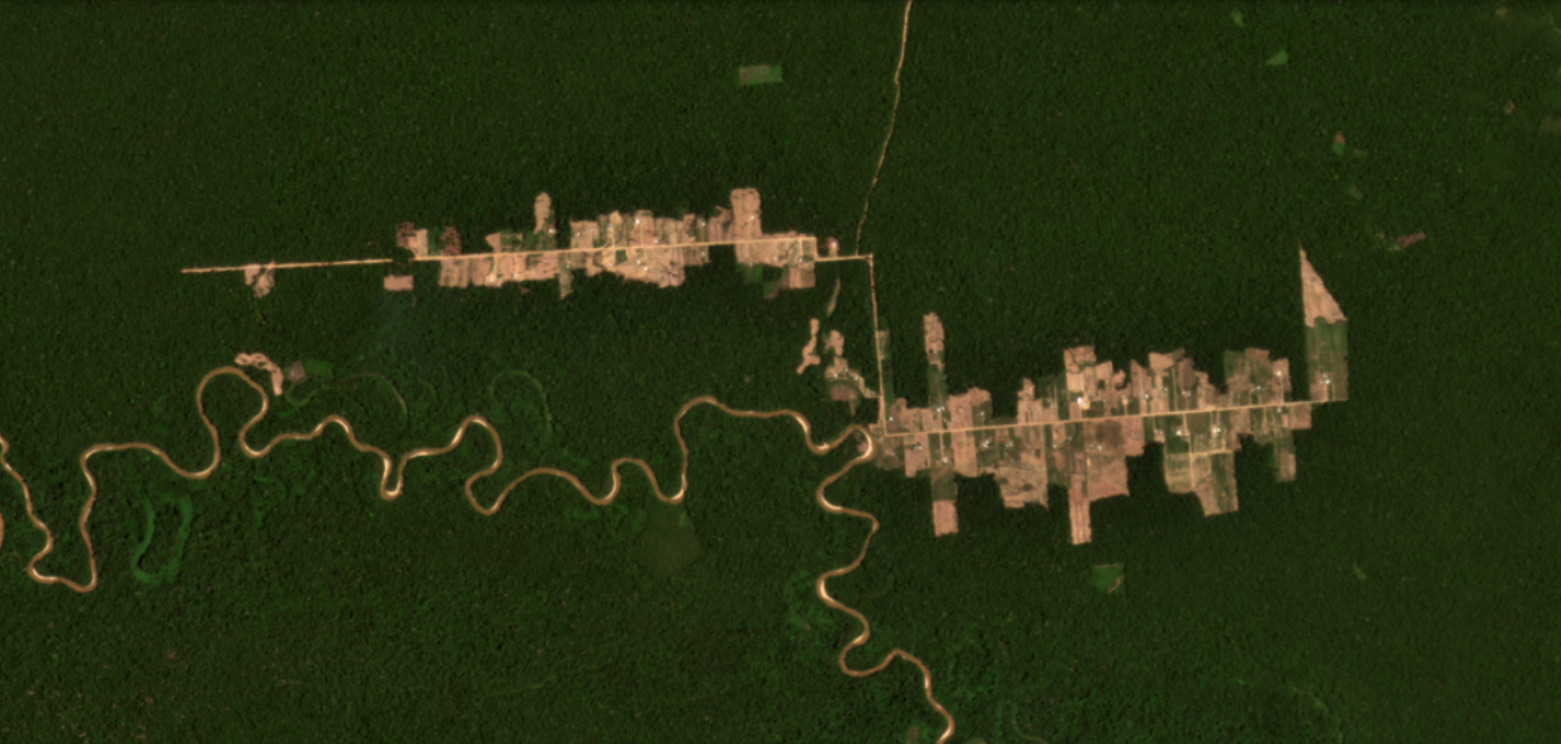
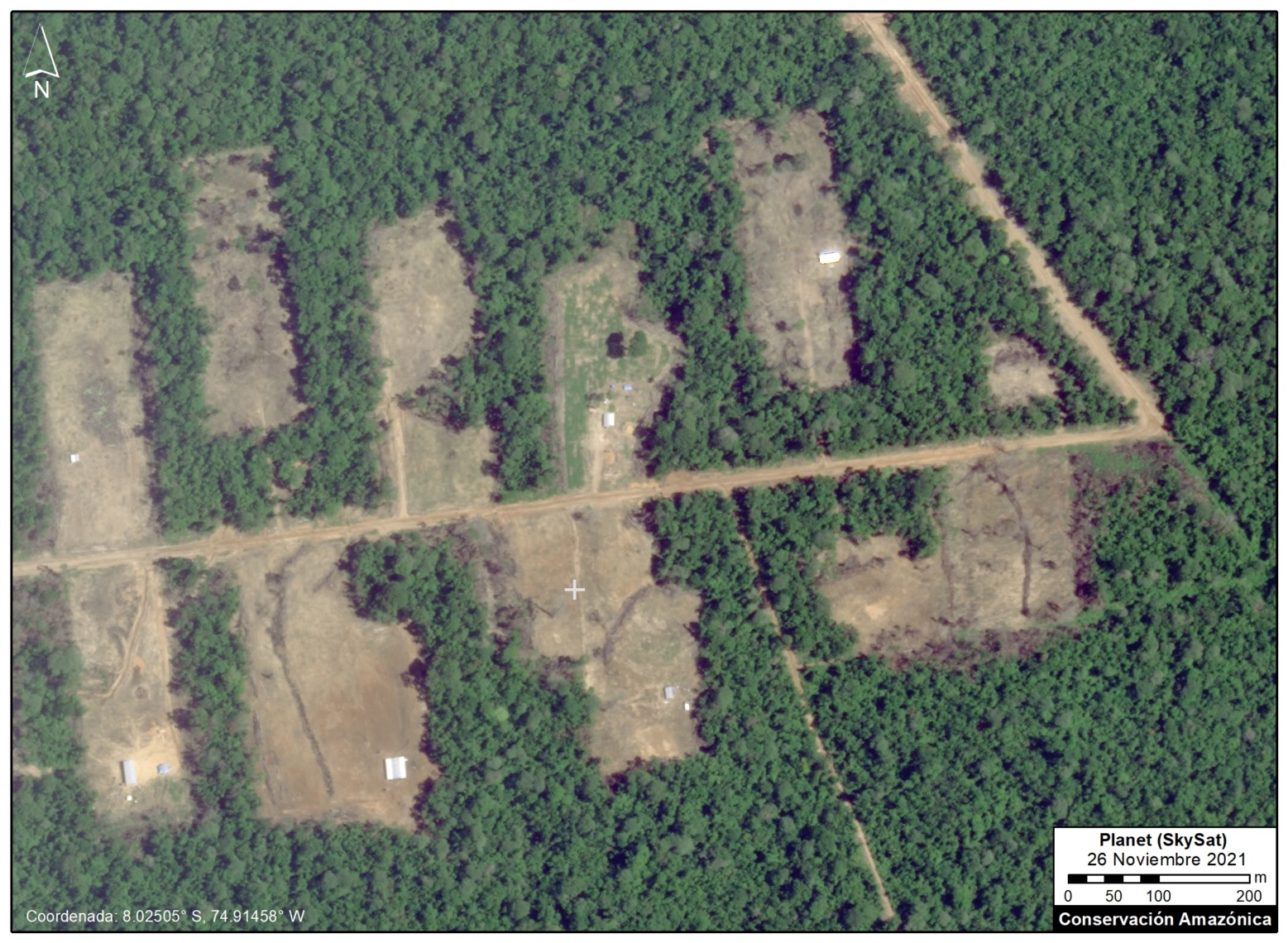
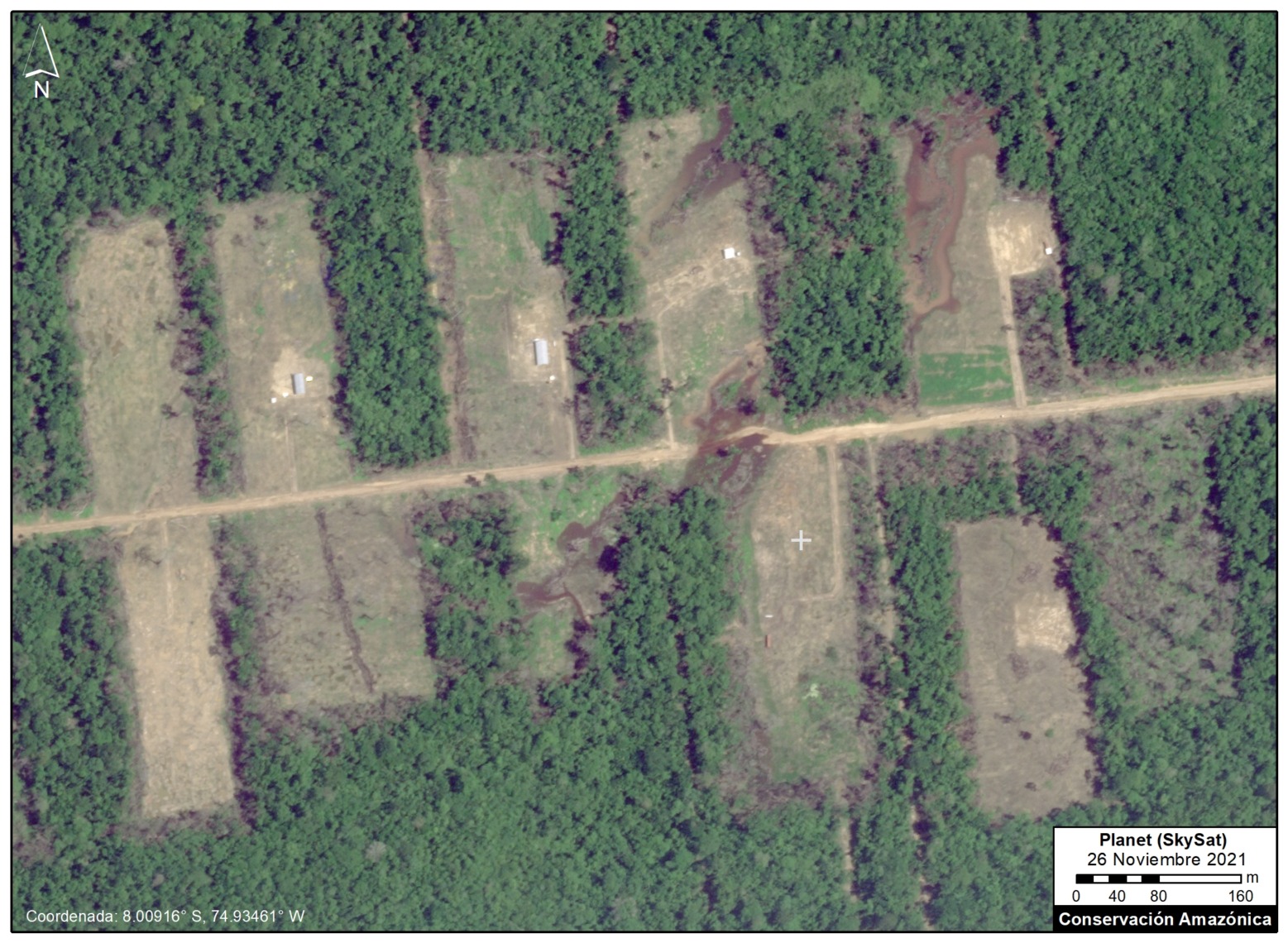
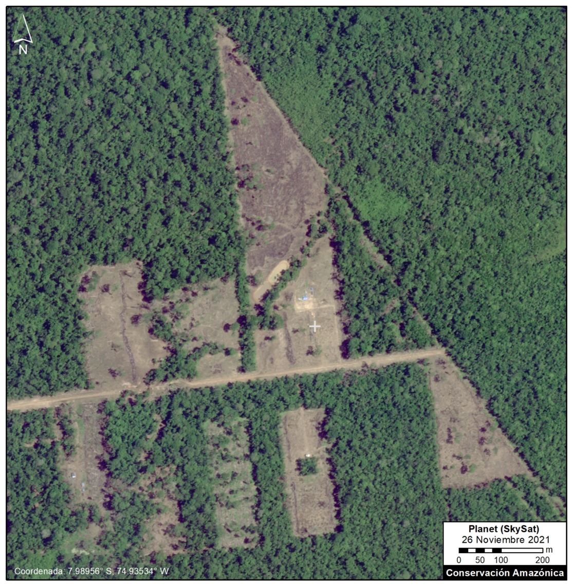
Very High-Resolution Images of Padre Marquez colony

Below, we present a series of very high resolution (0.5 meter) satellite images of the Padre Marquez colony, thanks to the company Planet and their Skysat fleet. The image allows enhanced visualization of some details of the deforested area, such as roads, buildings, and cleared land for likely agricultural activities. Click to enlarge.


Declaration from the Peruvian Ministry of Environment (MINAM):

La destrucción de cientos de hectáreas de bosques en Loreto y en Ucayali causada por las ocupaciones irregulares de colonias menonitas, ha sido priorizada por el MINAM a través de las siguientes acciones:

1. Denuncias penales por afectación de las formaciones boscosas, contra los dirigentes de las colonias menonitas.   Cuatro denuncias en Ucayali y una denuncia penal en Loreto.
2. Medidas cautelares, en el marco de las denuncias penales, para que la autoridad judicial disponga la suspensión de las acciones destructivas y predatorias del bosque.
3. Solicitudes a las entidades de control institucional para la supervisión sobre el ejercicio funcional de las autoridades regionales a cargo del otorgamiento de permisos que afectan el bosque.
4. Además, el MINAM ha venido ejecutando y coordinando diversas acciones con la finalidad que las entidades competentes investiguen, sancionen y paralicen las actividades irregulares de estas personas extranjeras que no solamente han ingresado sin las autorizaciones respectivas para ejecutar actividades económicas, sino que además están dañando ostensiblemente el patrimonio natural peruano.

Acknowledgements

We thank M.E. Gutierrez, E. Ortiz, S. Novoa, R. Catpo, D. Suarez and G. Palacios for helpful comments to earlier versions of this report.

This work was supported by the following major funders: Erol Foundation, Norwegian Agency for Development Cooperation (NORAD), and International Conservation Fund of Canada (ICFC).

Citation

Finer M, Mamani N, Spore J, Suarez D (2021)Mennonite Colonies Continue Major Deforestation in Peruvian Amazon. MAAP: 149.

MAAP #148: Carbon loss & protection in the Peruvian Amazon

Base Map. Data: MINAM/PNCB, Asner et al 2014. Forest loss data exaggerated for visual display.

Tropical forests store massive amounts of carbon. However, when these forests are cleared (and often subsequently burned), the stored carbon is released into the atmosphere, further driving global climate change.

The Amazon is the world’s largest tropical forest, with Peru forming the second-largest piece, directly to the west of Brazil (the largest).

The Peruvian Amazon is unique in having a high-resolution estimate of aboveground carbon dating back to 2013 (Asner et al 2014).

Here, we analyze this dataset in relation to recent deforestation data (see Base Map), seeking to identify the major carbon-related trends between 2013 and 2020.

Our key findings include:

  • We estimate the loss of over 100 million metric tons of carbon (101,498,000 MgC) in the Peruvian Amazon between 2013 and 2020, mostly due to deforestation from agriculture and mining. 
    k
  • In contrast, we estimate that protected areas and indigenous lands have safeguarded 3.2 billion metric tons of carbon (56% and 44%, respectively) in the Peruvian Amazon between 2013 and 2020.

The carbon loss noted above is equivalent to greenhouse gas emissions from nearly 80 million passenger vehicles driven for one year, or CO2 emissions from 92 coal-fired power plants in one year (EPA).

The carbon protection noted above is equivalent to greenhouse gas emissions from 2.5 billion passenger vehicles driven for one year, or CO2 emissions from nearly 3,000 coal-fired power plants in one year (EPA).

Reference Map. Location of zooms A-E.

Reference Map

Below, we present a series of zoom images of several key areas.

Zooms A-C highlight recent carbon loss due to deforestation (agriculture and mining) in high carbon density Amazon moist forests.

In contrast, Zooms D-E show how protected areas and indigenous lands are protecting massive amounts of carbon.

These letters (A-E) correspond to the reference map here.

Areas of Recent Carbon Loss

A. United Cacao

Zoom A shows the loss of nearly 300,000 metric tons of carbon for a large-scale cacao project (United Cacao) in the northern Peruvian Amazon (Loreto region).

Zoom A. United Cacao. Data: Asner et al 2014.

B. Mennonite Colony

Zoom B shows the recent deforestation and associated carbon loss for a new Mennonite colony in the central Peruvian Amazon (near the town of Tierra Blanca).

Zoom B. Mennonite Colony – Tierra Blanca. Data: MINAM/PNCB, Asner et al 2014.

C. Gold mining

Zoom C shows the loss of over 800,000 metric tons of carbon due to gold mining in the southern Peruvian Amazon (Madre de Dios region).

Zoom C. Gold mining in Madre de Dios region. Data: Asner et al 2014, MINAM/PNCB

Areas of Carbon Protection

D. Yaguas National Park

Zoom D shows how three protected areas, including the new Yaguas National Park, are effectively safeguarding over 200 million metric tons of carbon in the northeastern Peruvian Amazon.

Zoom D. Protected Areas in northeast Peru. Data: Asner et al 2014, MINAM/PNCB

E. Manu National Park

Zoom E shows how a group of protected areas (Manu National Park and Amarakaeri Communal Reserve) and the country’s first Conservation Concession (Los Amigos), is effectively safeguarding over 210 million metric tons of carbon in the southern Peruvian Amazon.

Zoom E. Protected Areas in southeast Peru. Data: Asner et al 2014, MINAM/PNCB

Methodology

This report combined two major datasets: 1) aboveground carbon from Asner et al 2014 and 2) annual forest loss identified by the Peruvian Environment Ministry’s National Forest Conservation Program (Geobosques) from the years 2013 to 2020.

The aboveground carbon data served as a baseline for 2013, and then we subsequently extracted the carbon data from the areas of forest loss from 2013-2020.

This process allowed us to obtain the carbon density (per hectare) in relation to the area of forest loss and then to estimate the total aboveground carbon stocks lost between 2013 and 2020.

The forest loss data values include some natural forest loss. Overall, however, they should be considered underestimates because they do not include forest degradation (for example, selective logging).

References

Asner GP et al (2014). The High-Resolution Carbon Geography of Perú. Carnegie Institution for Science.

EPA. Greenhouse Gas Equivalencies Calculator. https://www.epa.gov/energy/greenhouse-gas-equivalencies-calculator

Acknowledgements

We thank A. Folhadella, M. Hyde, ME Gutierrez, and G. Palacios for their helpful comments on this report.

This work was supported by NORAD (Norwegian Agency for Development Cooperation) and ICFC (International Conservation Fund of Canada).

Citation

Finer M, Mamani N (2021). Carbon loss & protection in the Peruvian Amazon. MAAP: 148.


MAAP #147: Amazon Deforestation Hotspots 2021 (1st Look)

Base Map. Deforestation hotspots across the Amazon in 2021 (as of September 18). Data: UMD/GLAD, ACA/MAAP.

We present a first look at the major deforestation hotspots across all nine countries of the Amazon in 2021 (as of September 18).*

The Base Map illustrates several key findings thus far in 2021:p

  • We estimate the loss of over 860,000 hectares (2.1 million acres) of primary forest loss across the nine countries of the Amazon.
    p
  • Amazon deforestation has been concentrated in three countries: Brazil (79%), Peru (7%), Colombia (6%).
    p
  • The vast majority of deforestation (79%) occurred in the Brazilian Amazon, where massive hotspots stretched across the major road networks. Many of these areas were also burned following the deforestation.
    p
  • There continues to be an arc of deforestation in the northwestern Colombian Amazon, impacting numerous protected areas and indigenous territories.
    p
  • In the Peruvian Amazon, deforestation continues to impact the central region, most notably from a new Mennonite colony and large-scale rice plantation.
    p
  • In Bolivia, fires are once again impacting several important ecosystems, including the Beni grasslands and Chiquitano dry forests of the Amazon, and Chaco scrub forest outside the Amazon.

Below, we zoom in on the three countries with the highest deforestation (Brazil, Colombia, and Peru) and show a series of high-resolution satellite images that illustrate some of the major 2021 deforestation events.

Widespread Deforestation in the Brazilian Amazon

The Brazil Base Map shows the notable concentration of deforestation hotspots along the major roads (especially roads 163, 230, 319, and 364). Zooms A-C show high-resolution examples of this deforestation, which largely appears to be associated with clearing rainforests for pasture.

Brazil Base Map. Deforestation hotspots in Brazilian Amazon (as of September 18). Data: UMD/GLAD, ACA/MAAP.
Zoom A. Deforestation in the Brazilian Amazon near road 230 (TransAmazian Highway) between February (left panel) and September (right panel) of 2021. Data: Planet.
Zoom B. Deforestation in the Brazilian Amazon along road 319 in Amazonas state between May (left panel) and September (right panel) of 2021. Data: Planet, ESA.
Zoom C. Deforestation in the Brazilian Amazon along road 163 between November 2020 (left panel) and September 2021 (right panel). Data: Planet, ESA.
Colombia Base Map. Deforestation hotspots in northwest Colombian Amazon (as of September 18). Data: UMD/GLAD, ACA/MAAP.

Arc of Deforestation in the Colombian Amazon

As described in previous reports (see MAAP #120), the Colombia Base Map shows there continues to be an “arc of deforestation” in the northwest Colombian Amazon (Caqueta, Meta, and Guaviare departments).

This arc impacts numerous protected areas (particularly Tinigua and Chiribiquete National Parks) and Indigenous Reserves (particularly Yari-Yaguara II and Nukak Maku).

Zooms D & E show high-resolution examples of this deforestation, which largely appears to be associated with clearing rainforests for pasture.

Zoom D. Deforestation in the Colombian Amazon (Caqueta) between December 2020 (left panel) and September 2021 (right panel). Data: Planet.
Zoom E. Deforestation in the Colombian Amazon between January (left panel) and September (right panel) of 2021. Data: Planet, ESA.
Peru Base Map. Deforestation hotspots in the Peruvian Amazon (as of September 18). Data: UMD/GLAD, ACA/MAAP.

Deforestation in the central Peruvian Amazon

The Peru Base Map shows the concentration of deforestation in the central Peruvian Amazon (Ucayali, Huanuco, and southern Loreto regions).

Zooms F & G show two notable examples of this deforestation: the rapid deforestation in 2021 for a new Mennonite colony (299 hectares) and large-scale rice plantation (382 hectares), respectively.

Also note some additional hotspots in the south (Madre de Dios region) from gold mining and medium-scale agriculture.

The hotspot in the north (Loreto region) is natural forest loss from a windstorm.

Zoom F. Deforestation (299 hectares) in the Peruvian Amazon for a new Mennonite colony between January (left panel) and September (right panel) of 2021 in southern Loreto region. Data: Planet.
Zoom G. Deforestation (382 ha) in the Peruvian Amazon for a new large-scale rice plantation between January (left panel) and September (right panel) of 2021 in Ucayali region. Data: Planet.

*Notes and Methodology

The analysis was based on 10-meter resolution primary forest loss alerts (GLAD+) produced by the University of Maryland and also presented by Global Forest Watch. These alerts are derived from the Sentinel-2 satellite operated by the European Space Agency.

We emphasize that this data represents a preliminary estimate and more definitive annual data will come later next year.

We also note that this data does include forest loss caused by natural forces and burned areas.

Our geographic range for the Amazon is a hybrid between both the biogeographic boundary (as defined by RAISG) and watershed  boundary, designed for maximum inclusion.

To identify the deforestation hotspots, we conducted a kernel density estimate. This type of analysis calculates the magnitude per unit area of a particular phenomenon, in this case forest cover loss. We conducted this analysis using the Kernel Density tool from Spatial Analyst Tool Box of ArcGIS. We used the following parameters:

Search Radius: 15000 layer units (meters)
Kernel Density Function: Quartic kernel function
Cell Size in the map: 200 x 200 meters (4 hectares)
Everything else was left to the default setting.

For the Base Map, we used the following concentration percentages: Medium: 7-10%; High: 11-20%; Very High: >20%.

Acknowledgements

We thank E. Ortiz and A. Ariñez for their helpful comments on this report.

This work was supported by NORAD (Norwegian Agency for Development Cooperation) and ICFC (International Conservation Fund of Canada).

Citation

Finer M, Mamani N, Spore J (2020) Amazon Deforestation Hotspots 2021. MAAP: 147.

MAAP #127: Mennonite Colonies Continue Major Deforestation in Peruvian Amazon

Recent deforestation associated with the Mennonite colony Tierra Blanca 1, in Loreto, Peru. Data: Planet

The Mennonites, a religious group often associated with organized agricultural activity, have started three new colonies in the Peruvian Amazon.

We have documented the deforestation of 8,500 acres (3,440 hectares) in these three colonies over the past four years (updated October 2020).

The deforestation started in 2017, but continues to be active in 2020 (with 1,900 acres lost, 25% of the total).

Notably, this combined Mennonite deforestation now exceeds the total loss from the infamous United Cacao case (2,400 hectares), one of the last major controversial large-scale deforestation cases in the Peruvian Amazon (MAAP #27).

Moreover, there are strong indications that the deforestation associated with these three Mennonite colonies is illegal (see Legality Statement below).

Below, we present the following:

  • A Base Map showing the location of the three new Mennonite colonies in the Peruvian Amazon.
  • A series of satellite images showing the recent deforestation in the most active colony (Tierra Blanca 1), including a very high resolution (0.5 meter) Skysat image.
  • a Legality Statement.
  • A graphic showing that the deforested area was not previously cleared (that is, it was intact forest).


Base Map. Location of the three new Mennonite Colonies in the Peruvian Amazon. Data: MAAP.

Base Map

The Base Map shows the location of the three new Mennonite colonies in the Peruvian Amazon.

Two colonies are located near the town of Tierra Blanca in the northern Peruvian Amazon (Loreto region).

The other colony is located near the town of Masisea in the central Peruvian Amazon (Ucayali region).

Of the total deforestation (8,500 acres):

  • 63% (5,370 acres) is from the colony Tierra Blanca 1;
  • 25% (2,145 acres) is from the colony Masisea;
  • 12% (990 acres) is from the colony Tierra Blanca 2.


Deforestation 2017-20

The following image shows the total deforestation of 5,370 acres (2,174 hectares) between November 2016 (left panel) and October 2020 (right panel), associated with the Mennonite colony Tierra Blanca 1. The red dot serves as a reference point between the two panels. Click to enlarge.

Deforestation between September 2016 (left panel) and October 2020 (right panel), associated with the Mennonite colony Tierra Blanca 1. Data: Planet, MAAP. Click to enlarge.

Deforestation 2020

The following image shows the most recent deforestation of 1,540 acres (625 hectares) between January 2020 (left panel) and October 2020 (right panel), associated with the Tierra Blanca 1 Mennonite colony. The red lines indicate new 2020 deforestation. Also see the Annex below for a map of the 2020 deforestation in relation to previous 2017-19 deforestation. Click to enlarge.

Deforestation between January 2020 (left panel) and October 2020 (right panel), associated with the Mennonite colony Tierra Blanca 1. Data: Planet, MAAP. Click to enlarge.

Very High Resolution Satellite Image (Skysat)

We recently obtained a very high resolution (0.5 meter) satellite image of the Tierra Blanca 1 colony, thanks to the company Planet and their Skysat fleet. The image allows enhanced visualization of some details of the deforested area, such as roads, buildings, and cleared land for likely agricultural activities. Click to enlarge.

Very high resolution satellite image (0.5 meters) over the Tierra Blanca 1 colony. Data: Planet (Skysat). Click to enlarge.

Legality Statement

Regarding the findings in Loreto (Tierra Blanca), we consulted with the Regional Government of Loreto who, in a document dated October 15, 2020, indicated that the Mennonite colonies do not have any approvals for the large-scale forest clearing in the area. The documented also indicated that they were coordinating with the environmental prosecutor’s office (known as FEMA) to investigate the case and its environmental impact.

Regarding the findings in Ucayali (Massisea), our investigations revealed that there is an investigation in progress by the environmental prosecutor’s office (FEMA). In addition, the regional government has initiated a sanctioning procedure for the alleged unauthorized land use change (deforestation) associated with Mennonite colony near Masisea.

Annex

We present a time series of satellite images ranging from 1985 to 2020 that shows that the major deforestation in the area began with the Mennonite intervention.

Annex. Deforestation in 2020 in relation to 2017-19, associated with Mennonite colony Tierra Blanca 1. Data: MAAP.

Acknowledgements

We thank S. Novoa and G. Palacios for helpful comments to earlier versions of this report.

This work was supported by the following major funders: Erol Foundation, Norwegian Agency for Development Cooperation (NORAD), and International Conservation Fund of Canada (ICFC).

Citation

Finer M, Mamani N, Suarez D (2020) MAAP: Mennonite Colonies Continue Major Deforestation in Peruvian Amazon Peruana. MAAP: 27.

MAAP #124: Deforestation Hotspots 2020 in the Peruvian Amazon.

Base Map. 2020 Forest Loss Hotspots in the Peruvian Amazon. Data: UMD/GLAD, MAAP, SERNANP.

We have entered the peak deforestation season in the Peruvian Amazon, so it is also a critical time for real-time monitoring (MAAP’s specialty).

Here, we highlight the major deforestation events documented so far in 2020 (through August 23).

The Base Map shows the current forest loss hotspots, indicated by the colors yellow, orange and red.

Below, we present the most urgent deforestation cases, caused by gold mining and agriculture (both large and small scale), the current leading deforestation drivers in Peru.

The Letters A-I on the Base Map correspond to the location of the cases described below.

One of the key cases is the new illegal gold mining hotspot along the Pariamanu river (Letter A in the southern Peruvian Amazon).

Another important case is the expanding large-scale agriculture by a Mennonite colony that continues causing an alarming deforestation.

The other cases deal with small-scale agriculture, which cumulatively represent the main deforestation driver in Peru.

Urgent Deforestation Cases 2020

1. Gold Mining

In MAAP #121, we reported that, in general, gold mining deforestation has decreased in the southern Peruvian Amazon following the government’s Operation Mercury, but it does continue in several critical areas. The images below show two of these areas (Pariamanu and Araza) with alarming new deforestation in 2020.

A. Pariamanu

The following image shows the gold mining deforestation of 52 acres (21 hectares) of primary forest along the Pariamanu River in the southern Peruvian Amazon (Madre de Dios region) between January (left panel) and August (right panel) of 2020. We highlight that the Peruvian government has just carried out an operation against the illegal mining activity in this area.

Pariamanu case (illegal gold mining). Data: Planet, MAAP.

B. Araza

The following image shows the gold mining deforestation of 114 acres (46 hectares) along the Chaspa River in the Puno region, between January (left panel) and August (right panel) of 2020.

Araza case. Data: Planet, MAAP.

2. Large-scale Agriculture

C. Mennonite Colony (near Tierra Blanca)

We reported last year that a new colony of Mennonites caused the deforestation of 4,200 acres (1,700 hectares) between 2017 and 2019 in the Loreto region (MAAP #112). The following image shows the additional deforestation of 820 acres (332 hectares) in 2020 between January (left panel) and August (right panel).

Mennonite case (near Tierra Blanca). Data: Planet, MAAP.

3. Small-scale Agriculture

D. Jeberos

In 2018, we reported on the construction of a new road (65 km) cutting through primary forest in the Loreto region, between the city of Yurimaguas and the town of Jeberos (MAAP #84). The following image shows the deforestation of 40 acres (16 hectares) along the new road in 2020, between January (left panel) and August (right panel).

Jeberos case (near Tierra Blanca). Data: Planet, MAAP.

E. Las Piedras

The following image shows the deforestation of 64 acres (26 hectares) of primary forest in a Brazil-nut concession along the Las Piedras River in the Madre de Dios region, between November 2019 (left panel) and August 2020 (right panel) .

Las Piedras case. Data: Planet, MAAP.

F. Bolognesi

The following image shows an example of deforestation (580 acres or 235 hectares) in one of the areas with the highest concentration of forest loss, located in the Ucayali region.

Bolognesi case. Data: Planet, MAAP.

G. Santa Maria de Nieva

The following image shows an example of deforestation(346 acres or 140 hectares) in another one of the areas with the highest concentration of forest loss, located in the Amazonas region.

Santa Maria de Nieva case. Data: Planet, MAAP.

H. Mishahua River

The following image shows the recent deforestation of 168 acres (68 hectares) along the Mishahua River, in the Ucayali region. Just to the north, we documented extensive deforestation along the Sepahua River in 2019, where it also appears to be starting up again in 2020.

Mishahua case. Data: Planet, MAAP.

I. South of Sierra del Divisor National Park

The following image shows an example of deforestation (166 acres or 67 hectares) in another one of the areas with the highest concentration of forest loss, located south of the Sierra del Divisor National Park in the Ucayali region.

Mishahua case. Data: Planet, MAAP.


Metodology

The analysis was based on early warning GLAD alerts from the Universidad de Maryland and Global Forest Watch.

To identify the deforestation hotspots, we conducted a kernel density estimate. This type of analysis calculates the magnitude per unit area of a particular phenomenon, in this case forest cover loss. We conducted this analysis using the Kernel Density tool from Spatial Analyst Tool Box of ArcGIS. We used the following parameters:

Search Radius: 15000 layer units (meters)
Kernel Density Function: Quartic kernel function
Cell Size in the map: 200 x 200 meters (4 hectares)
Everything else was left to the default setting.

For the Base Map, we used the following concentration percentages: Medium: 7-10%; High: 11-20%; Very High: >20%.

Acknowledgements

We thank S. Novoa and G. Palacios for helpful comments to earlier versions of this report.

This work was supported by the following major funders: Erol Foundation, Norwegian Agency for Development Cooperation (NORAD), and International Conservation Fund of Canada (ICFC).

Citation

Finer M, Mamani N (2020) Deforestation Hotspots 2020 in the Peruvian Amazon. MAAP: 124.

MAAP #124: Deforestation Hotspots 2020 in the Peruvian Amazon

Base Map. 2020 Forest Loss Hotspots in the Peruvian Amazon. Data: UMD/GLAD, MAAP, SERNANP.

We have entered the peak deforestation season in the Peruvian Amazon, so it is also a critical time for real-time monitoring (MAAP’s specialty).

Here, we highlight the major deforestation events documented so far in 2020 (through August 23).

The Base Map shows the current forest loss hotspots, indicated by the colors yellow, orange and red.

Below, we present the most urgent deforestation cases, caused by gold mining and agriculture (both large and small scale), the current leading deforestation drivers in Peru.

The Letters A-I on the Base Map correspond to the location of the cases described below.

One of the key cases is the new illegal gold mining hotspot along the Pariamanu river (Letter A in the southern Peruvian Amazon).

Another important case is the expanding large-scale agriculture by a Mennonite colony that continues causing an alarming deforestation.

The other cases deal with small-scale agriculture, which cumulatively represent the main deforestation driver in Peru.


Urgent Deforestation Cases 2020

1. Gold Mining

In MAAP #121, we reported that, in general, gold mining deforestation has decreased in the southern Peruvian Amazon following the government’s Operation Mercury, but it does continue in several critical areas. The images below show two of these areas (Pariamanu and Araza) with alarming new deforestation in 2020.

A. Pariamanu

The following image shows the gold mining deforestation of 52 acres (21 hectares) of primary forest along the Pariamanu River in the southern Peruvian Amazon (Madre de Dios region) between January (left panel) and August (right panel) of 2020. We highlight that the Peruvian government has just carried out an operation against the illegal mining activity in this area.

Pariamanu case (illegal gold mining). Data: Planet, MAAP.

B. Araza

The following image shows the gold mining deforestation of 114 acres (46 hectares) along the Chaspa River in the Puno region, between January (left panel) and August (right panel) of 2020.

Araza case. Data: Planet, MAAP.

2. Large-scale Agriculture

C. Mennonite Colony (near Tierra Blanca)

We reported last year that a new colony of Mennonites caused the deforestation of 4,200 acres (1,700 hectares) between 2017 and 2019 in the Loreto region (MAAP #112). The following image shows the additional deforestation of 820 acres (332 hectares) in 2020 between January (left panel) and August (right panel).

Mennonite case (near Tierra Blanca). Data: Planet, MAAP.

3. Small-scale Agriculture

D. Jeberos

In 2018, we reported on the construction of a new road (65 km) cutting through primary forest in the Loreto region, between the city of Yurimaguas and the town of Jeberos (MAAP #84). The following image shows the deforestation of 40 acres (16 hectares) along the new road in 2020, between January (left panel) and August (right panel).

Jeberos case (near Tierra Blanca). Data: Planet, MAAP.


E. Las Piedras

The following image shows the deforestation of 64 acres (26 hectares) of primary forest in a Brazil-nut concession along the Las Piedras River in the Madre de Dios region, between November 2019 (left panel) and August 2020 (right panel) .

Las Piedras case. Data: Planet, MAAP.

F. Bolognesi

The following image shows an example of deforestation (580 acres or 235 hectares) in one of the areas with the highest concentration of forest loss, located in the Ucayali region.

Bolognesi case. Data: Planet, MAAP.

G. Santa Maria de Nieva

The following image shows an example of deforestation(346 acres or 140 hectares) in another one of the areas with the highest concentration of forest loss, located in the Amazonas region.

Santa Maria de Nieva case. Data: Planet, MAAP.

H. Mishahua River

The following image shows the recent deforestation of 168 acres (68 hectares) along the Mishahua River, in the Ucayali region. Just to the north, we documented extensive deforestation along the Sepahua River in 2019, where it also appears to be starting up again in 2020.

Mishahua case. Data: Planet, MAAP.

I. South of Sierra del Divisor National Park

The following image shows an example of deforestation (166 acres or 67 hectares) in another one of the areas with the highest concentration of forest loss, located south of the Sierra del Divisor National Park in the Ucayali region.

Mishahua case. Data: Planet, MAAP.


Metodology

The analysis was based on early warning GLAD alerts from the Universidad de Maryland and Global Forest Watch.

To identify the deforestation hotspots, we conducted a kernel density estimate. This type of analysis calculates the magnitude per unit area of a particular phenomenon, in this case forest cover loss. We conducted this analysis using the Kernel Density tool from Spatial Analyst Tool Box of ArcGIS. We used the following parameters:

Search Radius: 15000 layer units (meters)
Kernel Density Function: Quartic kernel function
Cell Size in the map: 200 x 200 meters (4 hectares)
Everything else was left to the default setting.

For the Base Map, we used the following concentration percentages: Medium: 7-10%; High: 11-20%; Very High: >20%.

Acknowledgements

We thank S. Novoa and G. Palacios for helpful comments to earlier versions of this report.

This work was supported by the following major funders: Erol Foundation, Norwegian Agency for Development Cooperation (NORAD), and International Conservation Fund of Canada (ICFC).

Citation

Finer M, Mamani N (2020) Deforestation Hotspots 2020 in the Peruvian Amazon. MAAP: 124.

MAAP #112: Mennonite Colonies – New Deforestation Driver in the Amazon

Time-lapse deforestation in the “Tierra Blanca” Mennonite colony in Loreto, Peru. Data: Planet.

The Mennonites, a religious (Christian) group often dedicated to organized agriculture, are increasingly inhabiting the western Amazon (Peru and Bolivia).

Here, we reveal the recent deforestation of 18,500 acres (7,500 hectares) in three Mennonite colonies (see the Base Map below).

The two colonies in Peru (Tierra Blanca and Masisea) are new, causing the deforestation of 6,200 acres since 2017 (including 3,500 acres in 2019) in the Loreto and Ucayali regions.

The colony in Bolivia (Río Negro) is older, but deforestation recently began to increase again, causing the deforestation of 12,350 acres since 2017 in the department of Beni.

Next, we present a series of satellite image videos showing the deforestation in the three Mennonite colonies.


Tierra Blanca (Perú)

The Mennonite colony referred to here as “Tierra Blanca” is located in southern Loreto region, near the town of Tierra Blanca.

Video A shows the deforestation of 4,200 acres in the Tierra Blanca colony since 2017 (Planet link). We note that 2019 experienced the most deforestation (2,470 acres).


Masisea (Perú)

The Mennonite colony referred to here as “Masisea” is located in northern Ucayali region, near the town of Masisea.

Video B shows the deforestation of 2,000 acres in the Masisea colony since 2017 (Planet link). We note that 2019 experienced the most deforestation (865 acres).


In the detailed map in the Annex, note that the deforestation has reached the limit of a protected area, Imiría Regional Conservation Area. In addition, deforestation has occurred within two native communities (Buenos Aires and Caimito) and a Conservation Concession managed by a Peruvian university.

Río Negro (Bolivia)

The Mennonite colony Río Negro is located in southeastern Beni department. There are several Mennonite colonies in southern Bolivia, but this is one of the first deeper in the Amazon (Kopp, 2015).

Video C shows the deforestation of 12,350 acres in the Río Negro colony since 2017 (Planet link). Much of the deforestation occurred in 2017-18.


Annex 1: Base Map

Base Map of Mennonite colonies in Peru and Bolivia. Data: MAAP.

Annex 2: Detailed Maps

Deforestation in the three colonies A) Tierra Blanca, B) Masisea y C) río Negro. Data: UMD/GLAD, Hansen/UMD/Google/USGS/NASA

References

Kopp Ad (2015) Las colonias menonitas en Bolivia. Tierra. http://www.ftierra.org/index.php/publicacion/libro/147-las-colonias-menonitas-en-bolivia

Planet Team (2017). Planet Application Program Interface: In Space for Life on Earth. San Francisco, CA. https://api.planet.com

Acknowledgements

We thank H. Balbuena, A. Condor, and G. Palacios for helpful comments to earlier versions of this report.

This work was supported by the following major funders: Norwegian Agency for Development Cooperation (NORAD), MacArthur Foundation, International Conservation Fund of Canada (ICFC), Metabolic Studio, and Global Forest Watch Small Grants Fund (WRI).

Citation

Finer M, Mamani N (2019) Mennonite Colonies: New Deforestation Driver in the Amazon. MAAP: 112.