MAAP #92: New Deforestation Threats in the Peruvian Amazon (Part 2: Agriculture Expansion)

Base Map. Data: SERNANP, MAAP

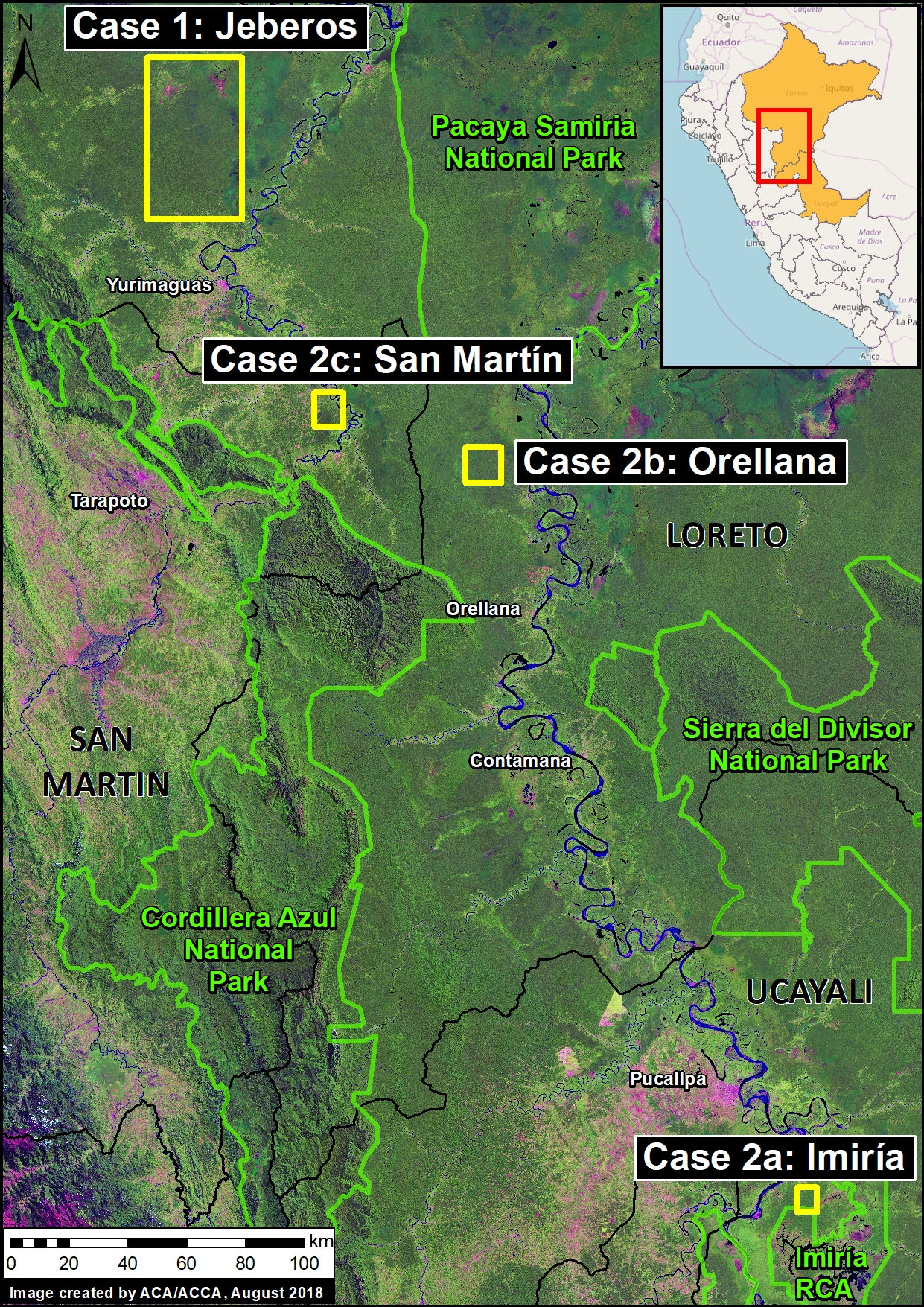
In this ongoing series, we describe major new projects that may lead to the rapid deforestation of large areas of primary Amazon forest.

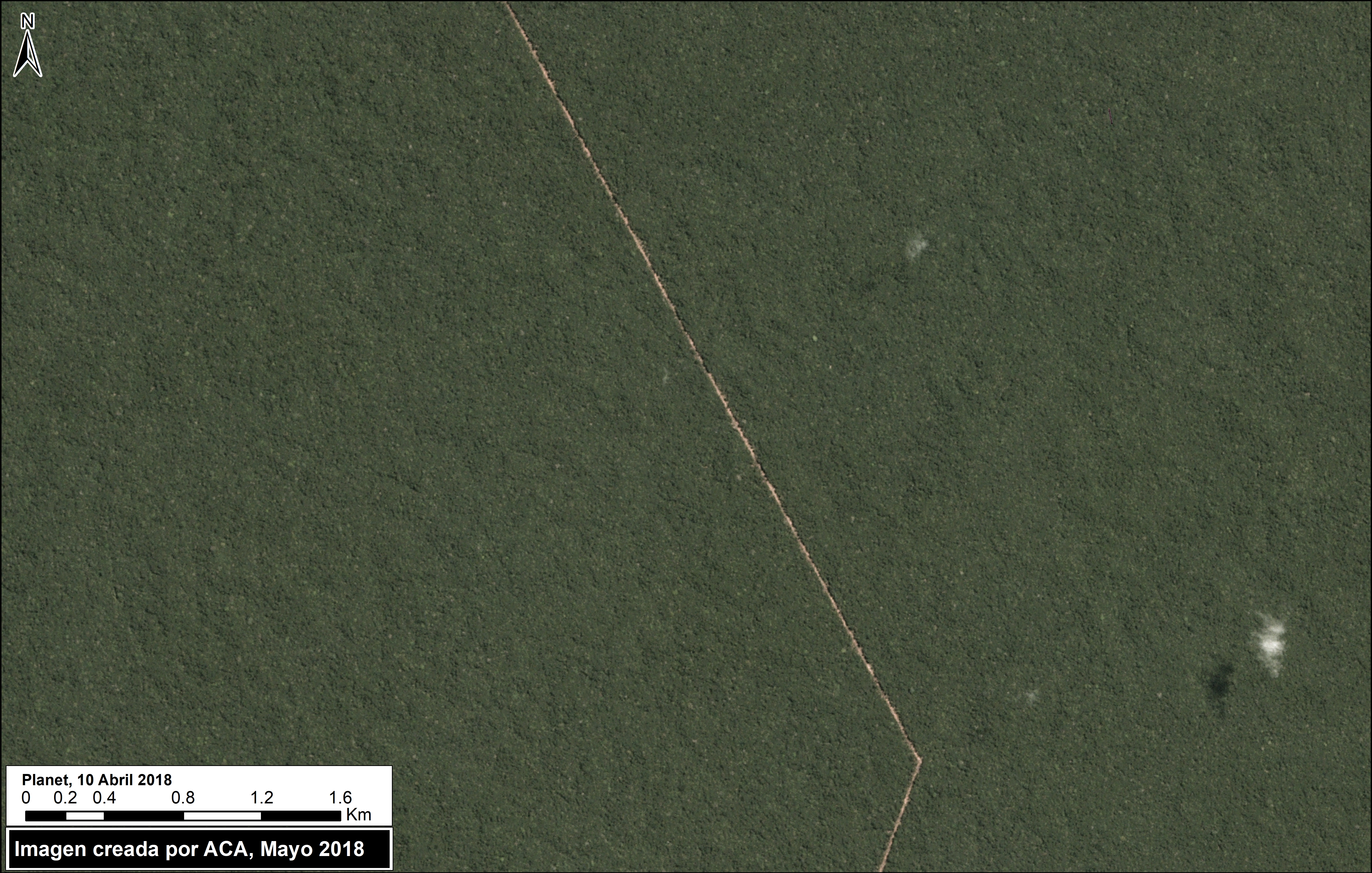
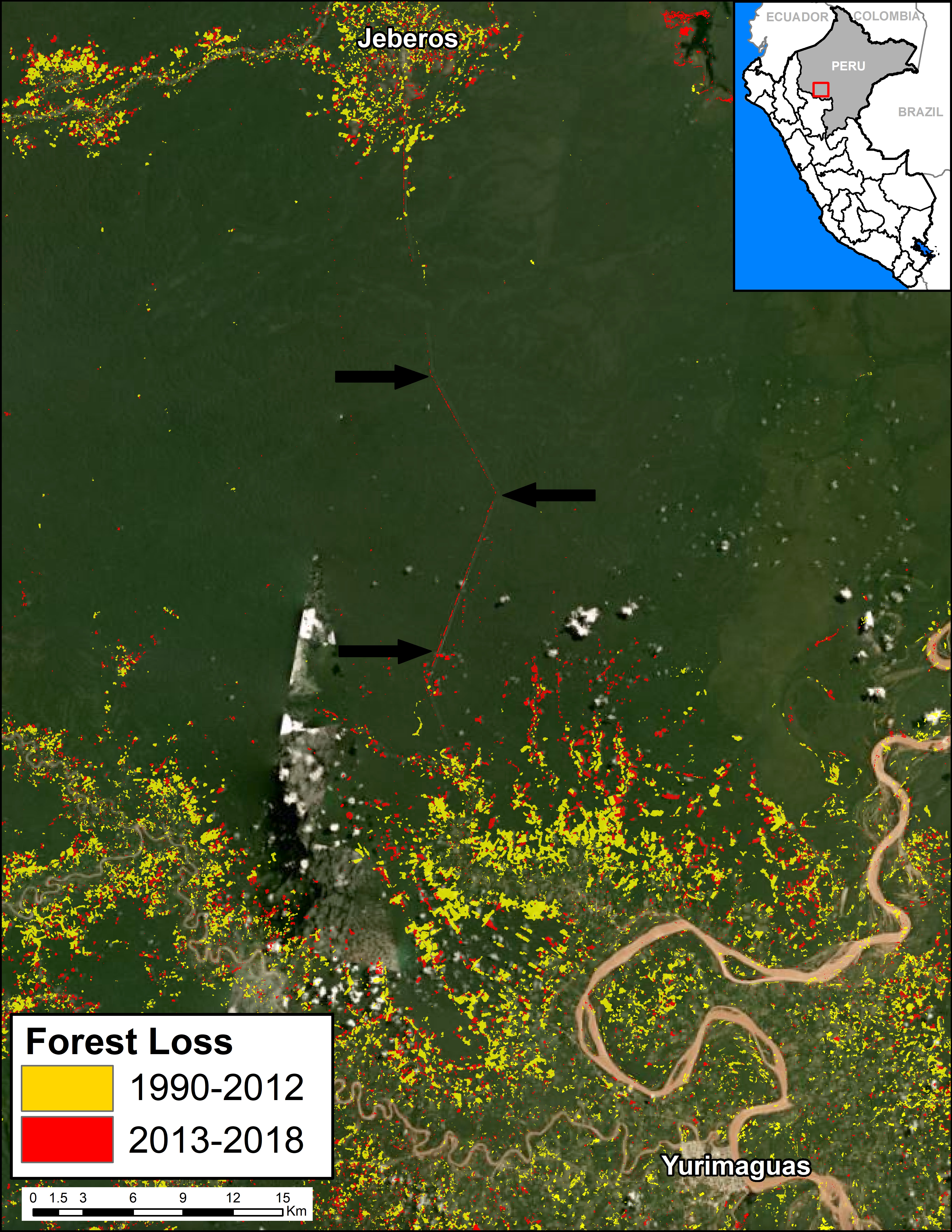
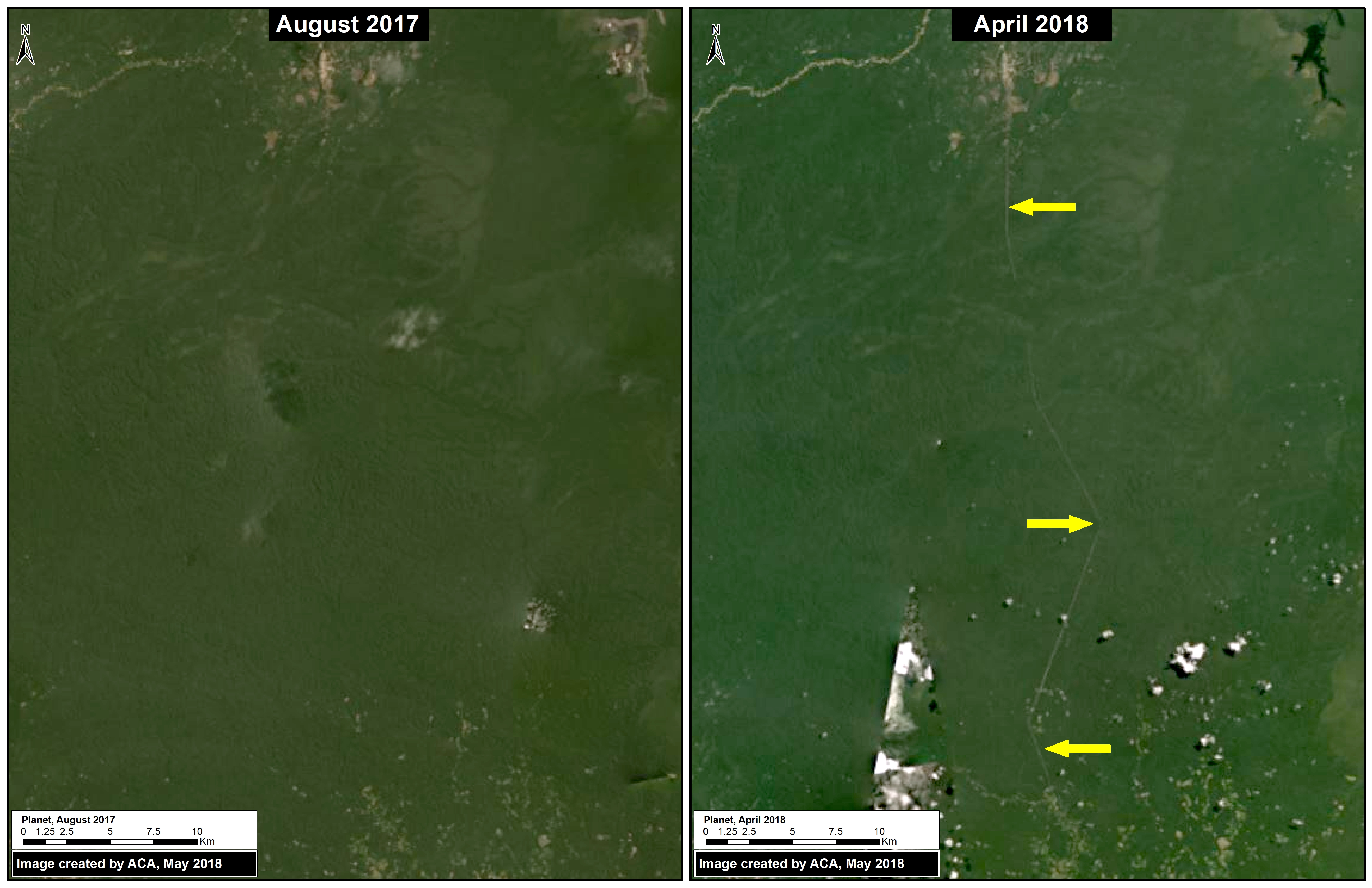
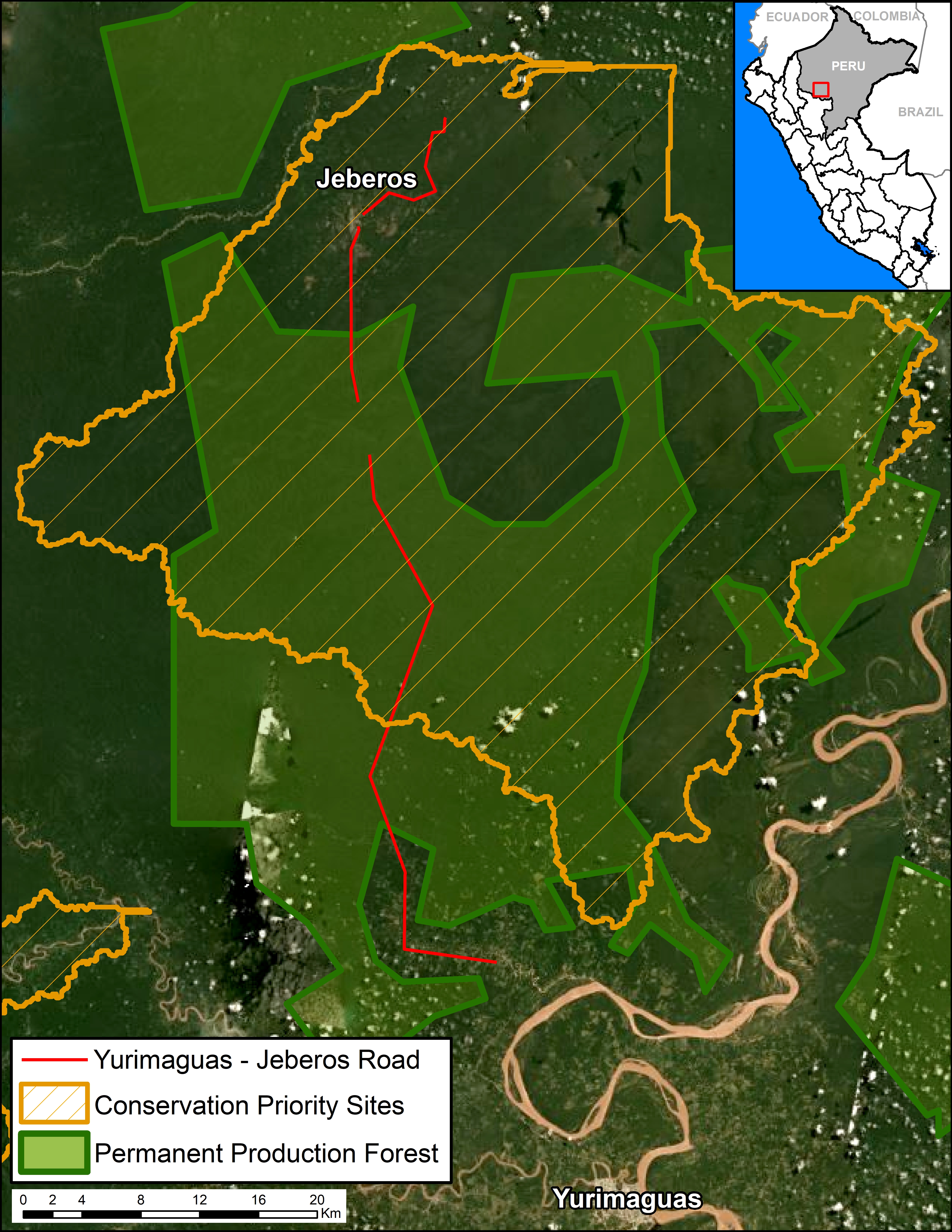
The first report (MAAP #84) described the deforestation associated with the construction of the Yurimaguas – Jeberos road (see Base Map), which crosses extensive primary forest and a priority site for conservation in the Loreto region.

The current report describes the deforestation associated with major agricultural expansion in three areas in the northern Peruvian Amazon, referred to here as the “Imiria,” “Orellana“, and “San Martin” cases.

These three cases are important because they present characteristics of large-scale, agro-industrial activities (linear plots organized around an extensive new access road network).

In all three cases, early warning alerts (GLAD/Global Forest Watch) initially detected the deforestation in 2017 (see MAAP #69) and their subsequent expansion in 2018. The total deforestation documented to date in these three cases is 3,600 acres.

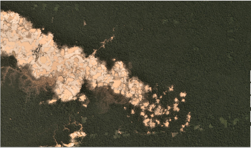
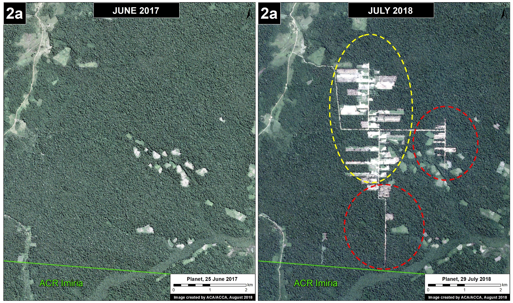
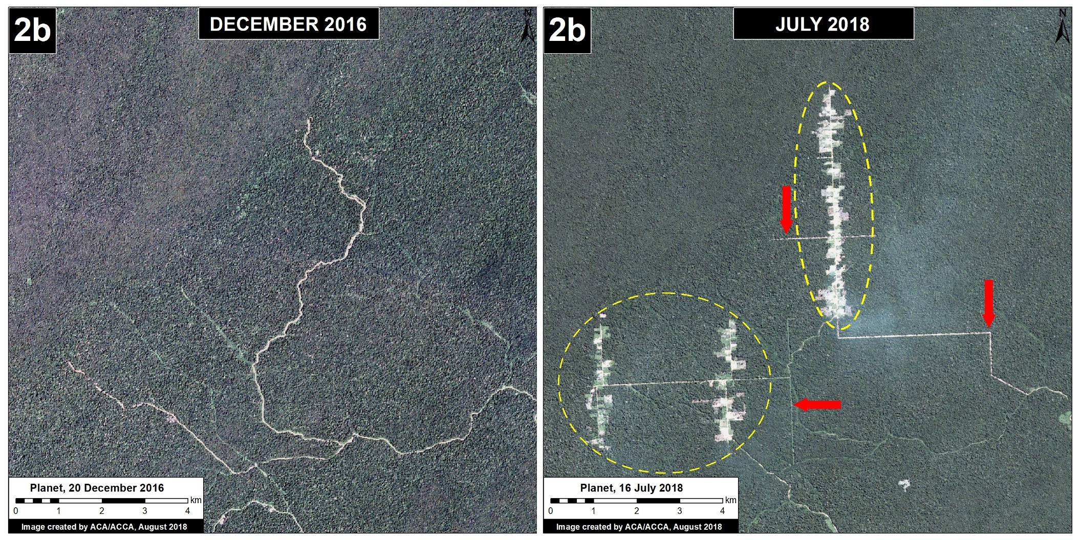
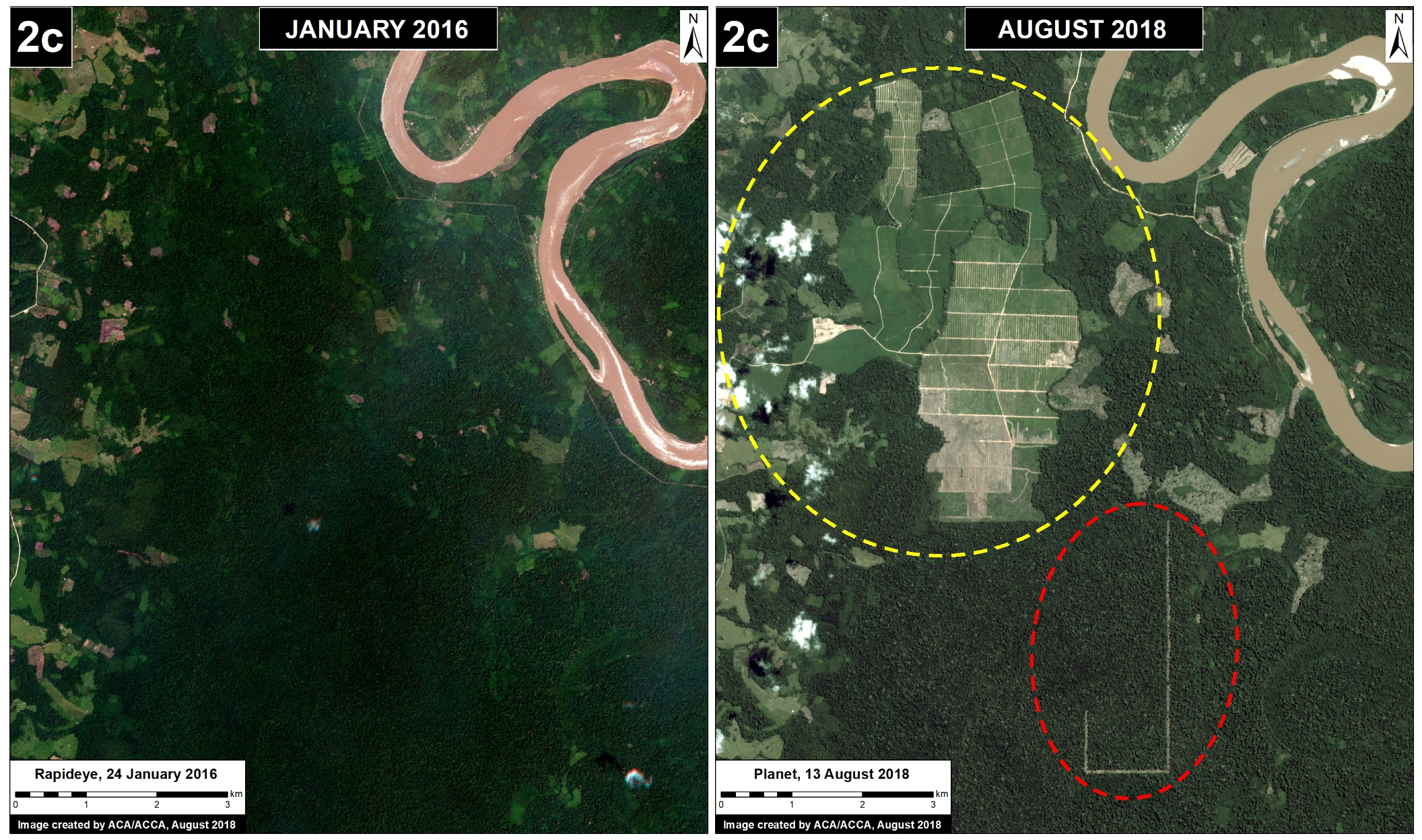
Below, we show satellite images of the most recent deforestation due to agricultural expansion in these three areas. In these images, yellow circles indicate 2016-17 deforestation and red circles/arrows indicate the most recent 2018 deforestation.


Imiría case (Ucayali)

Just to the north of the Imiría Regional Conservation Area, we documented the deforestation of 872 acres between June 2017 (left panel) and July 2018 (right panel). In the following image, note the organized deforestation around a new access road network. The red circles indicate the most recent 2018 deforestation. Also, note that the access road just reached the boundary of the Imiría Regional Conservation Area. Regarding the cause of deforestation, a recent news article indicates that a nearby indigenous community (Ceylan en Masisea) has reported the expansion of industrial-scale rice plantations.

Imiría case. (ACR = Regional Conservation Area) Data: Planet, SERNANP, MAAP

Orellana case (Loreto)

In the Loreto region, near the town of Orellana, we documented the deforestation of 902 acres between December 2016 (left panel) and July 2018 (right panel). In the following image, again note the organized deforestation around a new access road network. The red arrows indicate the new access roads built in 2018.

Orellana case. Data: Planet, MAAP

San Martin Case

In northeastern San Martín region, we documented the recent deforestation of 1,828 acres between December 2016 (left panel) and August 2018 (right panel) related to a new oil palm plantation. The red circle highlights the most recent 2018 deforestation, which indicates a major expansion of the plantation.

San Martin case. Data: Planet, MAAP

Coordinates

Imiria case: -8.733077,-74.369202
Orellana case: -6.569118,-75.357971
San Martín case: -6.26539,-75.800171

Citation

Finer M, Villa L (2018) New Deforestation Threats in the Peruvian Amazon (Part 2: Agriculture Expansion). MAAP: 92.

MAAP #91: Introducing PeruSAT-1, Peru’s new High-resolution Satellite

PeruSat-1. Credit: Airbus DS

In September 2016, Peru’s first satellite, PeruSAT-1, launched. It is Latin America’s most powerful Earth observation satellite, capturing images at a resolution of 0.70 meters.

The cutting-edge satellite was constructed by Airbus (France) and is now operated by the Peruvian Space Agency, CONIDA.

The organization Amazon Conservation was granted early access to the imagery to boost efforts related to near real-time deforestation monitoring.

Below, we present a series of PeruSAT images that demonstrate their powerful utility in terms of detecting and understanding deforestation in the Peruvian Amazon.


Gold Mining

We have reported extensively on the continuing gold mining deforestation in the southern Peruvian Amazon (see MAAP #87). We are now using PeruSAT to identify active and emerging mining deforestation fronts. For example, in the following images of an active mining zone, it is possible to clearly observe the environmental impact, and identify mining camps and wastewater pools.

PeruSAT-1 image of active gold mining. Data: ®CONIDA (2018), Distribution CONIDA, Peru; All rights reserved.
PeruSAT-1 image (zoom) of active gold mining. Data: ®CONIDA (2018), Distribution CONIDA, Peru; All rights reserved.

Agricultural Expansion

The following image shows a papaya plantation that appeared after a recent deforestation event near the Interoceanic highway in the southern Peruvian Amazon (Mavila, Madre de Dios). See MAAP #42 for more details on papaya emerging as new deforestation driver in this area.

PeruSAT-1 image of papaya plantation. Data: ®CONIDA (2018), Distribution CONIDA, Peru; All rights reserved.

Logging Roads

The following image shows, in high-resolution, a new logging road crossing primary forest in the southern Peruvian Amazon (district of Iñapari, Madre de Dios).

PeruSAT-1 image of logging road. Data: ®CONIDA (2018), Distribution CONIDA, Peru; All rights reserved.

Citation

Villa L, Finer M (2018) Introducing PeruSAT-1, Peru’s new High-resolution Satellite. MAAP: 91.

MAAP #90: Using Drones to monitor Deforestation and Illegal Logging

Drone types: helipcopter and fixed-wing (plane)

For the past three years, the organization Amazon Conservation has been working to establish a sustainable, local-based drones program for environmental monitoring in the southern Peruvian Amazon (Madre de Dios region).

This program is based on two types of drones, multi-rotor (helicopter style) and fixed-wing (airplane style).

One of the main objectives is to improve the near real-time monitoring of deforestation and illegal logging.

The monitoring is currently focused on three priority areas: 1) Brazil nut concessions, 2) forestry concessions of the local association ACOMAT, and 3) along the Interoceanic Highway (see Base Map).

Below, we show a series of drone images that we have used to identify the drivers of recent deforestation events. These drivers include gold mining, agriculture, illegal logging, cattle pasture, and natural forest loss.

Base Map. Priority areas of the Amazon Conservation drones initiative.

Interoceanic Highway

In March 2018, in collaboration with the organization ProPurús, we realized drone flights along the Interoceanic Highway in an effort to demonstrate the possible threats of building a new road along the border with Brazil (see MAAP #76). The following images show the two main threats to the area: gold mining and small/medium-scale agriculture (<50 hectares).

A. Drone image: gold mining.
B. Drone image: Deforestation from agriculture (corn)

Brazil Nut Concessions

In 2018, Amazon Conservation launched a new project, funded by Google Challenge, to develop a monitoring program for Brazil nut concessions covering a million hectares (2.47 million acres) in southern Peru. For example, the following image shows the invasion of a papaya plantation that caused the recent deforestation of five acres inside a concession.

C. Drone image: Invasión of papaya in Brazil nut concession.

ACOMAT Forestry Concessions

Since 2017, Amazon Conservation has been working on a project, financed by the Norwegian Agency for Development Cooperation (NORAD), to improve the monitoring of forest concessions of the local association ACOMAT (Association of Timber and Non-Timber Forest Concessionaires of the Provinces from Manu and Tambopata). The following images show examples of forest loss and degradation due to illegal logging, cattle grazing, natural loss (windstorm), and gold mining.

D. Drone image: illegal logging.
E. Drone image: cattle pasture.
F. Drone image: natural forest loss from windstorm.
G. Drone image: gold mining.

Citation

Garcia R, Novoa S, Castañeda C, Rengifo P, Jimenez M, Finer M (2018) Using Drones to monitor Deforestation and Illegal Logging. MAAP: 90.

MAAP #89: Impacts of Mining Project “Mirador” in the Ecuadorian Amazon


MAAP #89:
Impacts of Mining Project “Mirador” in the Ecuadorian Amazon
https://www.maapprogram.org/mirador-ecuador/

“Mirador” mining project in Ecuador.

The Ecuadorian Amazon is experiencing a growing number of conflicts directly related to oil and mining extraction projects.

Here, w
e focus on the “Mirador” mining project, an open pit copper mine in the Cordillera del Cóndor, a mountain range along the Ecuador/Peru border that hosts a high level of endemism.

We show a series of satellite images that highlight both the environmental impacts, such as the deforestation of over 3,200 acres, and social impacts, such as the forced eviction of communities.

*The Ecuador series is a collaboration between Amazon Conservation, Amazon Conservation Team, and EcoCiencia, funded by the MacArthur Foundation.

MAAP #89: Impacts of Mining Project “Mirador” in the Ecuadorian Amazon
https://www.maapprogram.org/mirador-ecuador/


MAAP #88: Deforestation Hotspots in the Ecuadorian Amazon

MAAP #88:
Deforestation Hotspots in the Ecuadorian Amazon
https://www.maapprogram.org/ecuador-hotspots/

Hotspots de deforestación en la Amazonía Ecuatoriana

Here, we highlight deforestation hotspots, the areas with the highest deforestation densities, in the mega-diverse Ecuadorian Amazon.

We then zoom in and focus on a dynamic area in the north that is located between three important protected areas (Sumaco, Yasuní y Cuyabeno).

We show a series of satellite images that indicate that the primary deforestation drivers (causes) in these hotspots are oil palm and other agricultural activities.

*The Ecuador series is a collaboration between Amazon Conservation, Amazon Conservation Team, and EcoCiencia, funded by the MacArthur Foundation

MAAP #88: Deforestation Hotspots in the Ecuadorian Amazon
https://www.maapprogram.org/ecuador-hotspots/


MAAP #87: Gold Mining deforestation continues in the Peruvian Amazon

Expansión hacia el este de mineria aurífera en La Pampa. Fuente: Planet.

We have reported extensively on the ongoing gold mining deforestation crisis in the southern Peruvian Amazon (see Archive), estimating the loss of over 17,500 acres in the five years between 2013 and 2017.

Here, we present new analysis showing that the destruction continues in 2018: we estimate an additional 4,265 acres during the first six months (January – June). This most recent deforestation is concentrated in two critical areas: La Pampa and Alto Malinowski. Most, if not all, of the mining appears to be illegal (see Annex).

This brings the total gold mining deforestation since 2013 to over 21,750 acres.

Next, we show a series of satellite images of the recent deforestation in La Pampa and Alto Malinowski.


Base Map

The Base Map highlights the most recent (2018) gold mining deforestation in red. We estimate this deforestation to be around 4,265 acres in the two most critical zones: La Pampa and Alto Malinowski. The yellow boxes indicate the location of the zooms described below. At the end of the article, in the Annex, we present the same base map but with all the overlapping land designations as well to illustrate the complexity of the situation.

Base Map. 2018 gold mining deforestation in southern Peruvian Amazon. Data: Planet, UMD/GLAD, MINAM/PNCB

La Pampa

The following images show the gold mining deforestation in the area known as “La Pampa” between January (left panel) and May (right panel) 2018. Note that the second image is in slider format.

Zoom de La Pampa. Datos: Planet, MAAP

[twenty20 img1=”7415″ img2=”7416″ width=”80%” offset=”0.5″]

Alto Malinowski

The following images show the gold mining deforestation in the area known as “Alto Malinowski” between January (left panel) and May (right panel) 2018. Note that the second image is in slider format.

[twenty20 img1=”7417″ img2=”7418″ width=”80%” offset=”0.5″]

Annex

We present the same base map as above, but also with relevant land designations.  Note that much of the deforestation is concentrated in forestry concessions (ironically, in “reforestation” concessions) and in the Kotsimba Native Community, both of which are outside the legal mining corridor and within the buffer zones of Tambopata National Reserve and Bahuaja Sonene National Park. Thus, most, if not all, of the mining activity appears to be illegal.

Citation

Finer M, Villa L, Mamani N (2018) Gold Mining continues to ravage the Peruvian Amazon. MAAP: 87.

MAAP Colombia: Chiribiquete – Deforestation Hotspots in the Colombian Amazon, part 3

MAAP #86: Deforestation Hotspots in the Colombian Amazon, part 3: Chiribiquete-Macarena

We present our third report* in a series investigating deforestation hotspots in the Colombian Amazon. Here, we focus on the “Chiribiquete-Macarena” hotspot, located between the Chiribiquete and La Macarena National Parks.

The Colombian government is finalizing plans to expand the boundaries of Chiribiquete National Park, an important step for conservation. However, we show (with high-resolution images) that deforestation is surging in the area and rapidly expanding towards these new boundaries. In fact, in 2018, deforestation has entered the newly expanded park.

MAAP #86: Deforestation Hotspots in the Colombian Amazon, part 3: Chiribiquete-Macarena

https://www.maapprogram.org/chiribiquete/


*The first report focused on the “Caguan” hotspot in the department of Caquetá. The second report focused on the “La Paya” hotspot in the department of Putumayo.

Science Magazine_Combating Deforestation: From Satellite to Intervention

**************************************************************************************************

Science Magazine: Combating deforestation: From satellite to intervention
Full text
Reprint (PDF)
:

*Note: The article can only be viewed for free via this author page.

************************************************************************************************

A new policy article entitled “Combating deforestation: From satellite to intervention” was just published in Science, one of the leading journals in the world.

The authors include members of Amazon Conservation, World Resources Institute (Global Forest Watch), and Planet.

We first describe how rapidly improving satellite technology has created an unprecedented moment for near real-time monitoring.

We then outline a five-step protocol for near real-time tropical deforestation monitoring, with the goal of bridging the gap between technology and policy.

Satellite image of expanding gold mining deforestation in Peru. Image: Planet.

MAAP #85: Illegal Logging in the Peruvian Amazon, and how Satellites can help address it

Example of new logging road in the Peruvian Amazon. Data: Planet

We propose a new tool to address illegal logging in the Peruvian Amazon: using cutting-edge satellites to monitor logging road construction in near real-time.

Illegal logging in the Amazon is difficult to detect because it is selective logging of individual valuable trees, not large clear-cuts.

However, a new generation of satellites can quickly detect new logging roads, which in turn may indicate the leading edge of illegal logging.

Here, we analyzed satellite imagery to identify all new logging roads built in the Peruvian Amazon over the past three years (2015-17).

We then show how it is possible to track logging road construction in near-real time, using three satellite-based systems: GLAD alerts, Sentinel-1 (radar satellites), and Planet (optical satellites).


The Technology

GLAD alerts. Source: GFW

GLAD alerts quickly detect areas of recent forest loss (based on 30 meter resolution Landsat imagery) and highlight those pixels. For example, the image on the right shows GLAD alerts for a recent logging road. The satellites described below can then zoom in on these highlighted areas and continue the monitoring in near real-time.

The European Space Agency’s Sentinel-1 satellites freely offer a new image every 12 days no matter the weather conditions, as radar technology allows it to penetrate clouds (see MAAP #79).

The company Planet has a fleet of 175+ mini satellites, lined up like pearls in a necklace, that are able to capture a high-resolution optical image almost daily, though clouds remain an issue (see MAAP #59).


Key Findings

Base Map. Logging roads in the Peruvian Amazon. Data: MAAP, SERNANP, IBC. Click to enlarge.

The Base Map illustrates the location of all logging roads built in the Peruvian Amazon since 2001.

We estimate the construction of 1,365 miles (2,200 km) of logging roads during the last three years (2015-17). We indicate these roads in red.

Note that the roads are concentrated in three zones:

  • Southern Loreto, between Cordillera Azul and Sierra del Divisor National Parks;
  • Southern Ucayali; and
  • Northeast Madre de Dios.

Another important finding is the potential rapid speed of logging road construction: up to 1.5 miles (2.5 km) per week.

Next, we focus on two emblematic logging roads (near Sierra del Divisor and Cordillera Azul National Parks, respectively) to demonstrate the feasibility of near real-time monitoring based on Sentinel-1 and Planet satellites.


A. Logging Road near Sierra del Divisor

Image A1 is a GIF that shows a series of radar images (Sentinel-1) of the construction of a logging road between 2015 and 2017 just north of Sierra del Divisor National Park. The length of the road is 43 miles (69 km). Image A2 is a Planet image showing the status of the road as of the end of 2017.

Image A1. Construction of logging road near Sierra del Divisor. Data: ESA
Image A2. Logging road near Sierra del Divisor. Data: Planet

B. Logging Road near Cordillera Azul

Image B1 is a GIF that shows a series of radar images (Sentinel-1) of the construction of a logging road between 2015 and 2017 east of Cordillera Azu National Park. The length of the road is 33 miles (53 km). Image B2 is a Planet image showing the status of the road as of the end of 2017.

Image B1. Construction of logging road near Cordillera Azul. Data: ESA
Image B2. Logging road near Cordillera Azul. Data: Planet

Notes

Not all illegal logging requires roads, but logging roads may indicate some of the most organized, financed, and large-scale operations.

Coordinates

Zona A: -6.966982,-74.6521
Zona B: -7.650428,-75.552979

Citation

Villa L, Finer M (2018) Illegal Logging in the Peruvian Amazon, and how Satellites can help. MAAP: 85.

MAAP #84: New Threats to the Peruvian Amazon (Part 1: Yurimaguas-Jeberos Road)

Image A: New Yurimaguas-Jeberos road crossing primary forest. Data: Planet

The efforts and international commitments of the Peruvian Government to reduce deforestation may be compromised by new projects do not have adequate environmental assessment.

In this series, we address the most urgent of these projects, those that threaten large areas of primary Amazonian forest.

We believe that these projects require urgent attention from both government and civil society to ensure an adequate response and avoid irreversible damage. For example, in the case below, it is not known whether there is an environmental impact study.

The first report of this series focuses on a new road (Jeberos – Yurimaguas) that threatens a large expanse of primary forest in the northern Peruvian Amazon (see Image A).


Yurimaguas-Jeberos Road

Image B. Data: GLAD/UMD, PNCB/MINAM, Hansen/UMD/Google/USGS/NASA

Early warning forest loss alerts (GLAD alerts from the University of Maryland and Global Forest Watch) have detected the construction of a new road between the city of Yurimaguas and the town of Jeberos, in southern Loreto region (see Image B).

We estimate that the new road is 65 km (40 miles). In the image, the arrows indicate part of the route crossing primary forest (indicated in dark green).

Although the road improves the connectivity of an isolated town, the problem is that much of it crosses primary Amazon forest and may trigger massive deforestation. It is well documented that roads are one of the main drivers of deforestation in the Amazon (see MAAP #76).

In addition, most of the route crosses “Permanent Production Forest“, a legal land classification restricted to forestry activities, not agriculture or infrastructure (Image D). The route also crosses a regional conservation priority site (Image D).

It is important to note that the Regional Government of Loreto, which is promoting and financing the project, specifically said in a press statement that the road will “encourage the expansion of the agricultural and livestock frontier in this part of the region.” That phrase can be interpreted as frankly stating that the road will cause extensive deforestation. It is a particularly troubling scenario given that Yurimaguas is already a deforestation hotspot.


Image C shows the beginning of road construction between August 2017 (left panel) and April 2018 (right panel).

Image C. Road construction. Data: Planet.

Image D shows how the road crosses Permanent Production Forest and a regional conservation priority site.

Image D. Data: GOREL, MINAGRI, MAAP

Citation

Finer M, Mamani N (2018) New Threats to the Peruvian Amazon (Part 1: Yurimaguas-Jeberos Road). MAAP: 84.