MAAP #43: Early Warning Deforestation Alerts in the Peruvian Amazon, Part 2

In the previous MAAP #40, we emphasized the power of combining early warning forest loss GLAD alerts with analysis of high-resolution satellite imagery as part of a comprehensive near real-time deforestation monitoring system for the Peruvian Amazon.

In the current MAAP, we present 3 new examples of this system across different regions of Peru. Click on the images below to enlarge.

Example 1: Illegal Gold Mining in buffer zone of Bahuaja Sonene National Park (Madre de Dios)
Example 2: Logging Road in buffer zone of Cordillera Azul National Park (Ucayali/Loreto)
Example 3: Deforestation in Permanent Production Forest (Ucayali)

Example 1: Illegal Gold Mining in buffer zone of Bahuaja Sonene National Park (Madre de Dios)

In the previous MAAP #5, we discussed illegal gold mining deforestation along the upper Malinowski River, located in the buffer zone of the Bahuaja Sonene National Park. As seen in Image 43a, the upper Malinowski is just upstream of the areas invaded by illegal gold mining in Tambopata National Reserve and its buffer zone (see MAAP #39 and #31, respectively). In MAAP #5, we documented the deforestation of more than 850 hectares between 2013 and 2015 along the upper Malinowski. Here, we show that gold mining deforestation continues in 2016, with an additional loss of 238 hectares (806 acres). Insets A-C correspond to the areas featured in the high-resolution zooms below.

Image 43a. Data: UMD/GLAD, Hansen/UMD/Google/USGS/NASA, NASA/USGS, SERNANP

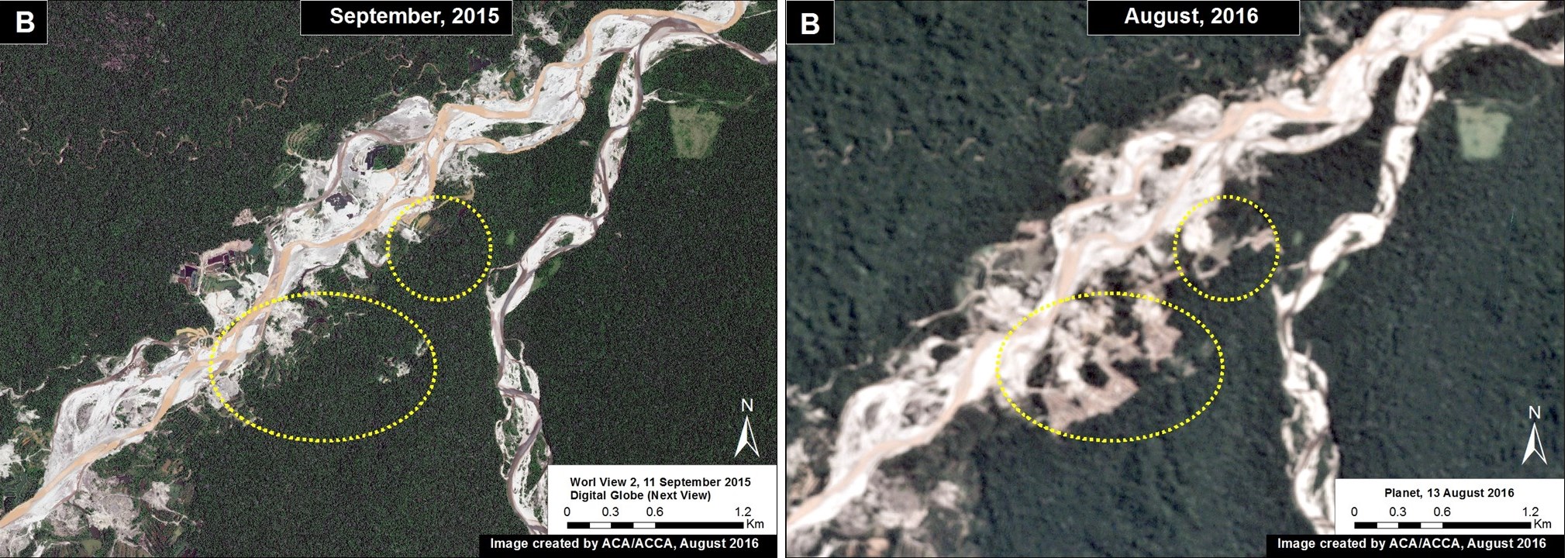
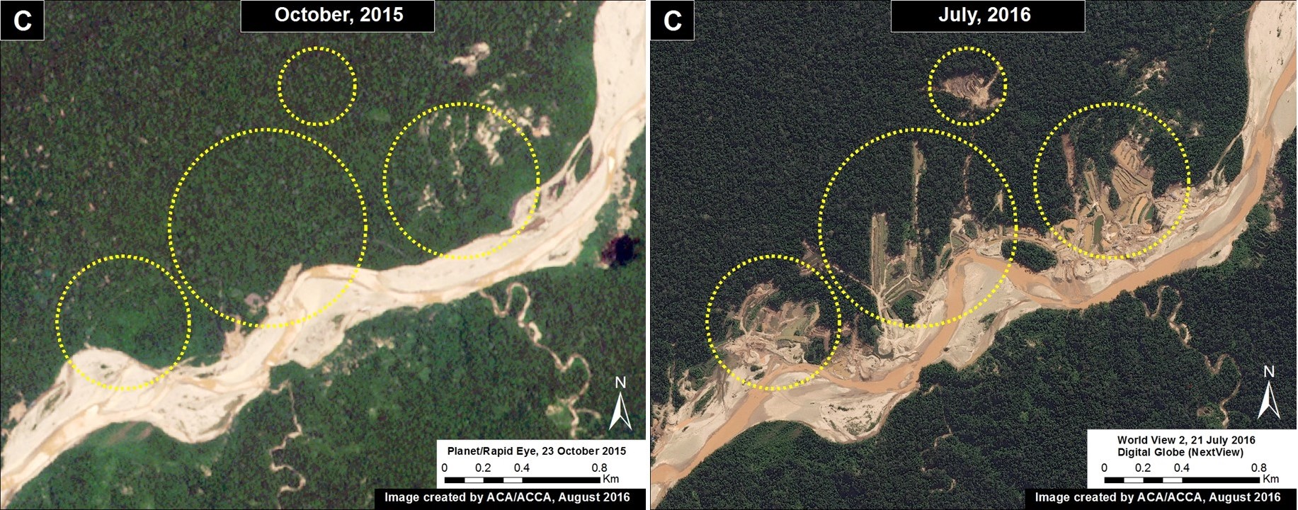
The following Images 43b-d show, in high-resolution, the rapid expansion of gold mining deforestation between August/September 2015 (left panel) and July/August 2016 (right panel). The yellow circles indicate the main areas of deforestation between the images.

Imagen 43b. Datos: Planet, Digital Globe (Nextview)
Image 43b. Data: Planet, Digital Globe (Nextview)
Imagen 43c. Datos: Planet, Digital Globe (Nextview)
Image 43c. Data: Planet, Digital Globe (Nextview)
Imagen 43d. Datos: Planet, Digital Globe (Nextview)
Image 43d. Data: Planet, Digital Globe (Nextview)

Example 2: Logging Road in buffer zone of Cordillera Azul National Park (Ucayali/Loreto)

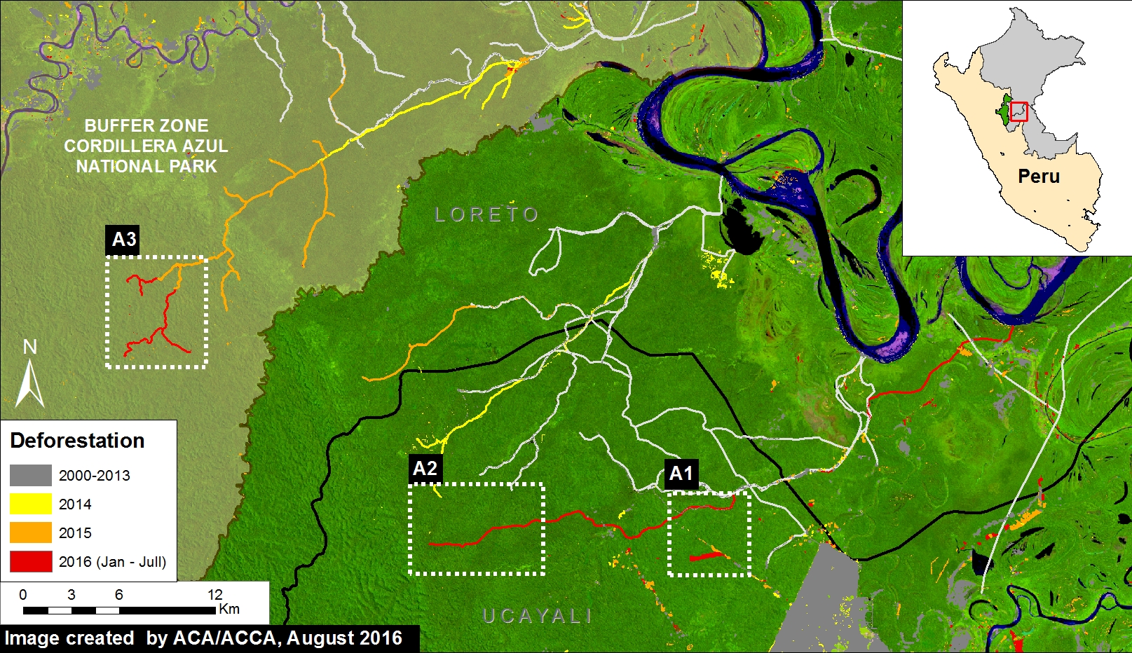
In the previous MAAP #18, we discussed the proliferation of logging roads in the central Peruvian Amazon in 2015. Here, we show the expansion of two of these logging roads in 2016. (see Image 43e). Red indicates construction during 2016 (47 km). Insets A1-A3 correspond to the areas featured in the high-resolution zooms below. Note that the northern road (Inset A3) is within the buffer zone of Cordillera Azul National Park. Evidence suggests that this road is not legal because it extends out of the permited area (see MAAP #18 for more details).

Imagen 43e. Datos: UMD/GLAD, Hansen/UMD/Google/USGS/NASA, SERNANP
Image 43e. Data: UMD/GLAD, Hansen/UMD/Google/USGS/NASA, SERNANP

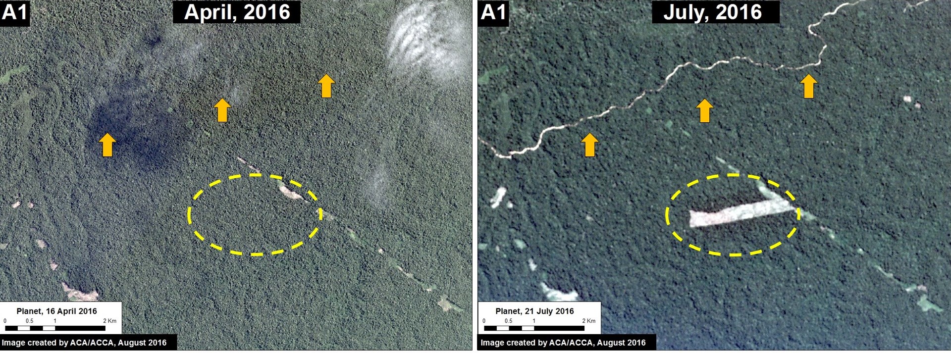
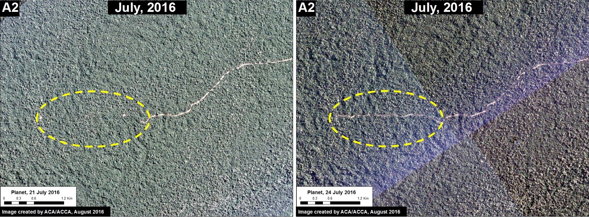
The following images show, in high-resolution, the rapid construction of these logging roads. Image 43f shows the construction of part of the southern road (Inset A1), and the deforestation for a nearby agricultural parcel, between April (left panel) and July (right panel) 2016. Image 43g shows the construction of 1.8 km in just three days along this same road (Inset A2) between July 21 (left panel) and July 24 (right panel) 2016.

Imagen 43f. Datos: Planet
Image 43f. Data: Planet
Imagen 43g. Datos: Planet
Image 43g. Data: Planet

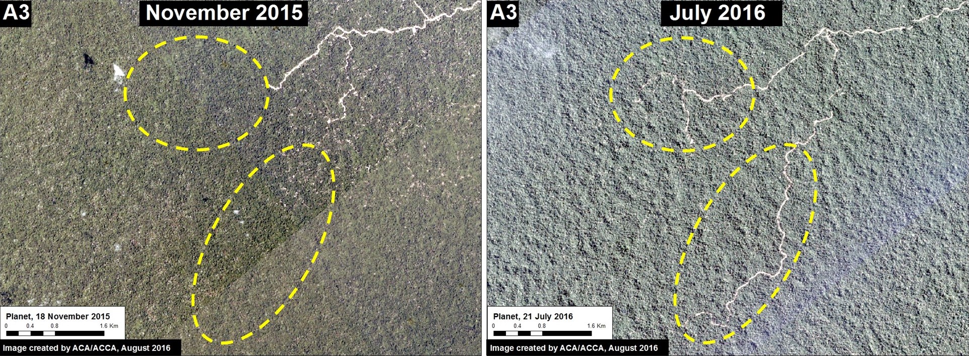
Image 43h shows the construction of 13 km on the northern road between November 2015 (left panel) and July 2016 (right panel) within the buffer zone of the Cordillera Azul National Park.

Imagen 43h. Datos: Planet
Image 43h. Data: Planet

Example 3: Deforestation in Permanent Production Forest  (Ucayali)

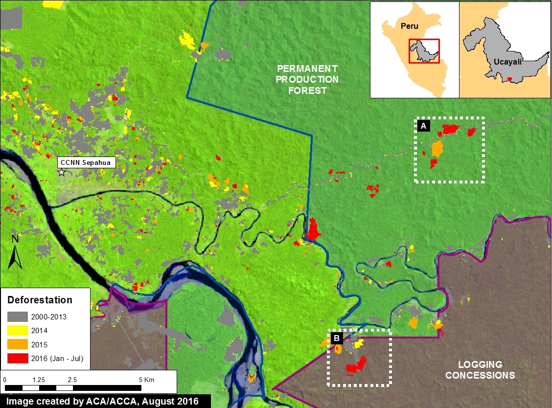
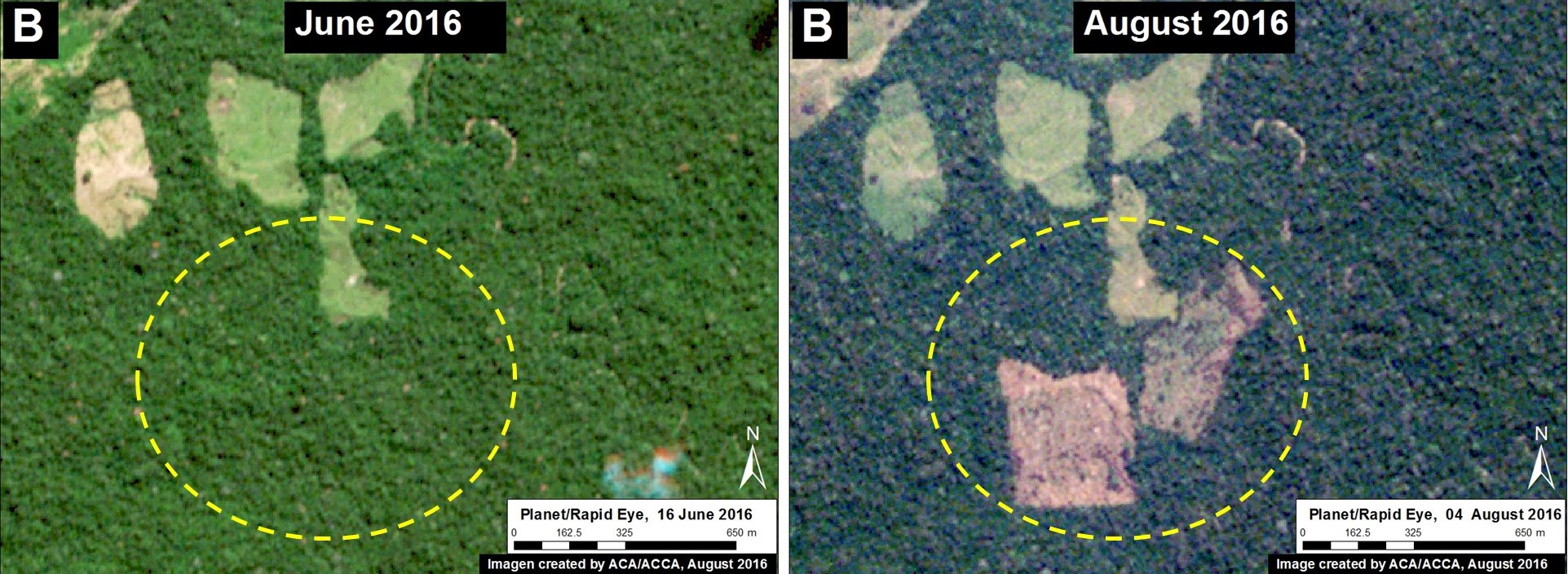
Image 43i shows recent deforestation of 136 hectares (336 acres) in 2016 in southern Ucayali region within areas classified as Permanent Production Forest and Foresty Concession. These types of areas are generally zoned for sustainable forestry uses, not clear-cutting, thus we question the legality of the deforestation. Tables A-B correspond to the areas featured in the high-resolution zooms, below.

Imagen 43i. Datos: UMD/GLAD, Hansen/UMD/Google/USGS/NASA, MINAGRI
Image 43i. Data: UMD/GLAD, Hansen/UMD/Google/USGS/NASA, MINAGRI

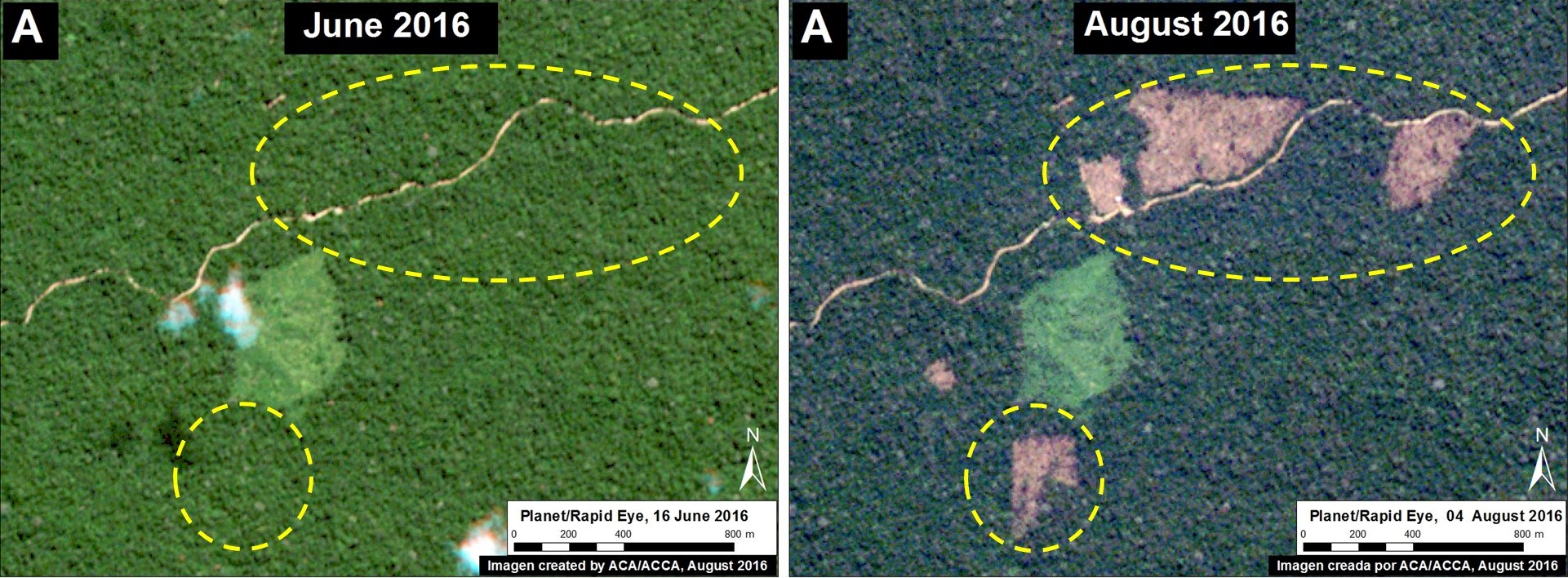
Image 43j shows deforestation within a section of Permanent Production Forest, and Image 43k shows deforestation within a section of Forestry Concession.

Imagen 43j. Datos: Planet
Image 43j. Data: Planet
Imagen 43k. Datos: Planet
Image 43k. Data: Planet

Citation

Finer M, Novoa S, Goldthwait E (2016) Early Warning Deforestation Alerts in the Peruvian Amazon, Part 2. MAAP: 43.

MAAP #40: Early Warning Deforestation Alerts in the Peruvian Amazon

GLAD alerts are a powerful new tool to monitor forest loss in the Peruvian Amazon in near real-time. This early warning system, created by the GLAD (Global Land Analysis and Discovery) laboratory at the University of Maryland and supported by Global Forest Watch, was launched in March 2016 as the first Landsat-based (30-meter resolution) forest loss alert system (previous systems were based on lower-resolution imagery). The alerts are updated weekly and can be accessed through Global Forest Watch (Image 40a, left panel) or GeoBosques (Image 40a, right panel), a web portal operated by the Peruvian Ministry of Environment.

Imagen 41a. Datos: UMD/GLAD, WRI/GFW, PNCB/MINAM
Image 40a. Data: UMD/GLAD, WRI/GFW, PNCB/MINAM

In MAAP, we often combine these alerts with analysis of high-resolution satellite imagery (courtesy of the Planet Ambassador Program and Digital Globe NextView service) to better understand patterns and drivers of deforestation in near real-time. In this article, we highlight 3 examples of this type of innovative analysis from across the Peruvian Amazon:

Example 1: Logging Roads in central Peru (Ucayali)
Example 2: Invasion of Ecotourism Concessions in southern Peru (Madre de Dios)
Example 3: Buffer Zone of Cordillera Azul National Park (Loreto)

Example 1: Logging Roads in central Peru (Ucayali)

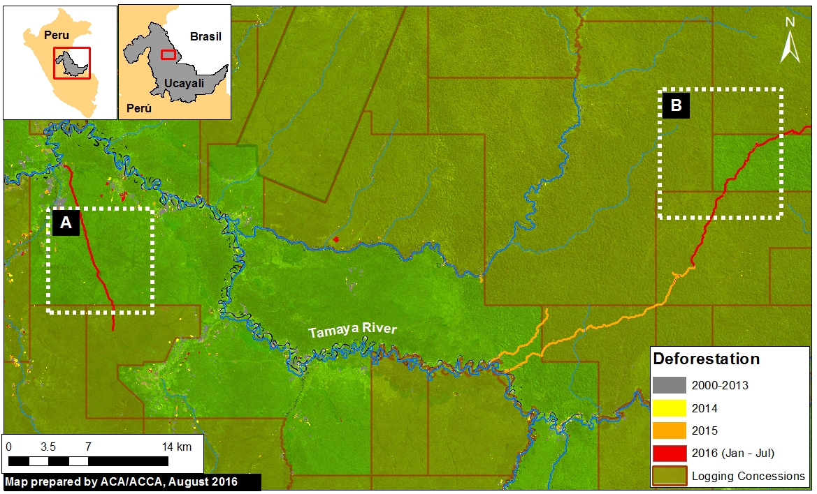
In the previous MAAP #18, we documented the proliferation of logging roads in the central Peruvian Amazon during 2015. In recent weeks, we have seen the start of rapid new logging road construction for 2016. Image 40b shows the linear forest loss associated with two new logging roads along the Tamaya river in the remote central Peruvian Amazon (Ucayali region). Red indicates the 2016 road construction (35.8 km). Insets A and B indicate the areas shown in the high-resolution zooms below.

Image 40b. Data: UMD/GLAD, Hansen/UMD/Google/USGS/NASA, MINAGRI

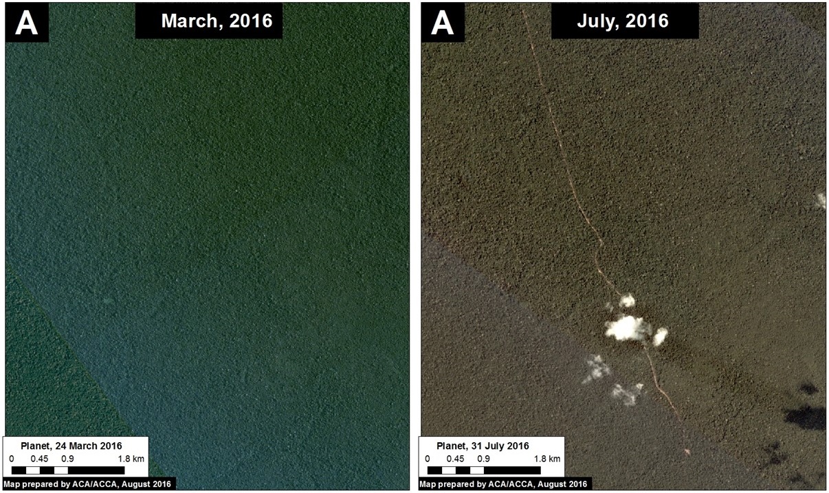
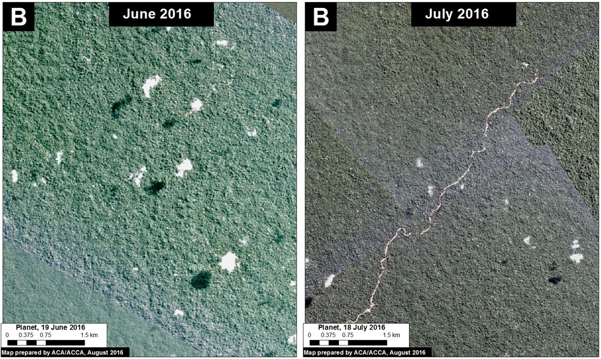
The following images show, in high-resolution, the rapid construction of logging roads in 2016. Image 40c shows the construction of 16.1 km between March (left panel) and July (right panel) 2016 in the area indicated by Inset A. Image 40d shows the construction of 19.7 km between June (left panel) and July (right panel) 2016 in the area indicated by Inset B.

Image 40c. Data: Planet
Image 40d. Data: Planet

Example 2: Invasion of Ecotourism Concessions in southern Peru (Madre de Dios)

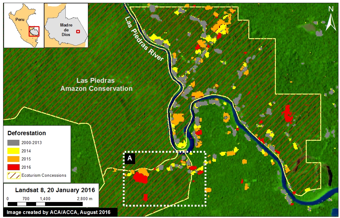
Image 40e shows the recent deforestation within two ecotourism concessions along the Las Piedras River in the Madre de Dios region. Red indicates the 2016 GLAD alerts (67.3 hectares). Note that the Las Piedras Amazon Center (LPAC) Ecotourism Concession represents an effective barrier against deforestation occurring in the surrounding concessions. According to local sources, the main drivers of deforestation in the area are related to the establishment of cacao plantations and cattle pasture (see s MAAP #23). Inset A indicates the areas shown in the high-resolution zoom below.

Image 40e. Data: UMD/GLAD, Hansen/UMD/Google/USGS/NASA, MINAGRI

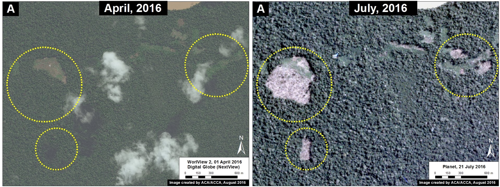
Image 40f shows high-resolution images of the area indicated by Inset A between April (left panel) and July (right panel) 2016. The yellow circles indicate areas of deforestation between these dates.

Image 40f. Data: Planet, DigitalGlobe (Nextview)

Example 3: Buffer Zone of Cordillera Azul National Park (Loreto)

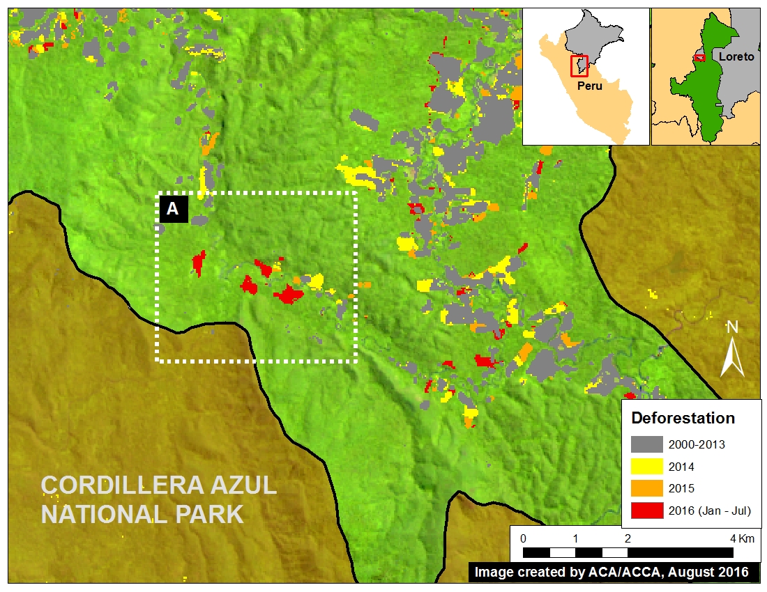
Image 40g shows the recent deforestation within the western buffer zone of the Cordillera Azul National Park in the Loreto region. Red indicates the 2016 GLAD alerts (87.3 hectares). It is worth noting that this area is classified as Permanent Production Forest, not as an agricultural area.

Image 40g. Data: SERNANP, Landsat, UMD/GLAD, Hansen/UMD/Google/USGS/NASA

Image 40h shows high-resolution images of the area indicated by Inset A between December 2015 (left panel), January 2016 (central panel), and July 2016 (right panel). The yellow circles indicate areas that were deforested between these dates. The driver of the deforestation appears to be the establishment of small-scale agricultural plantations.

Image 40h. Data: RapidEye/Planet, Digital Globe (Nextview)

Citation

Finer M, Novoa S, Goldthwait E (2016) Early Alerts of Deforestation in the Peruvian Amazon. MAAP: 40.

MAAP #32: Large-scale vs. Small-scale Deforestation in the Peruvian Amazon

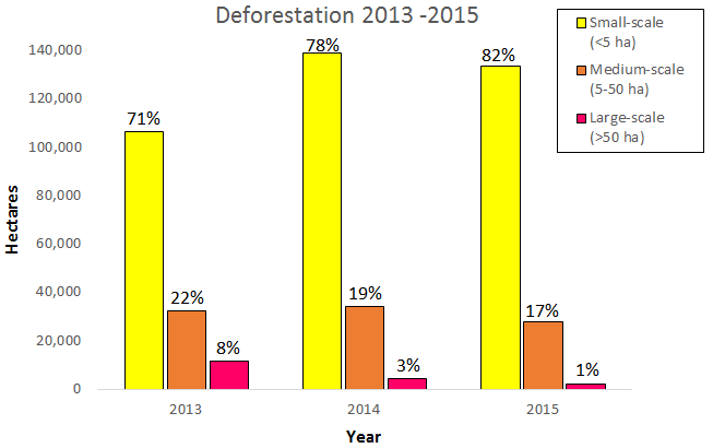
Graph 32a. Data: PNCB/MINAM, UMD/GLAD

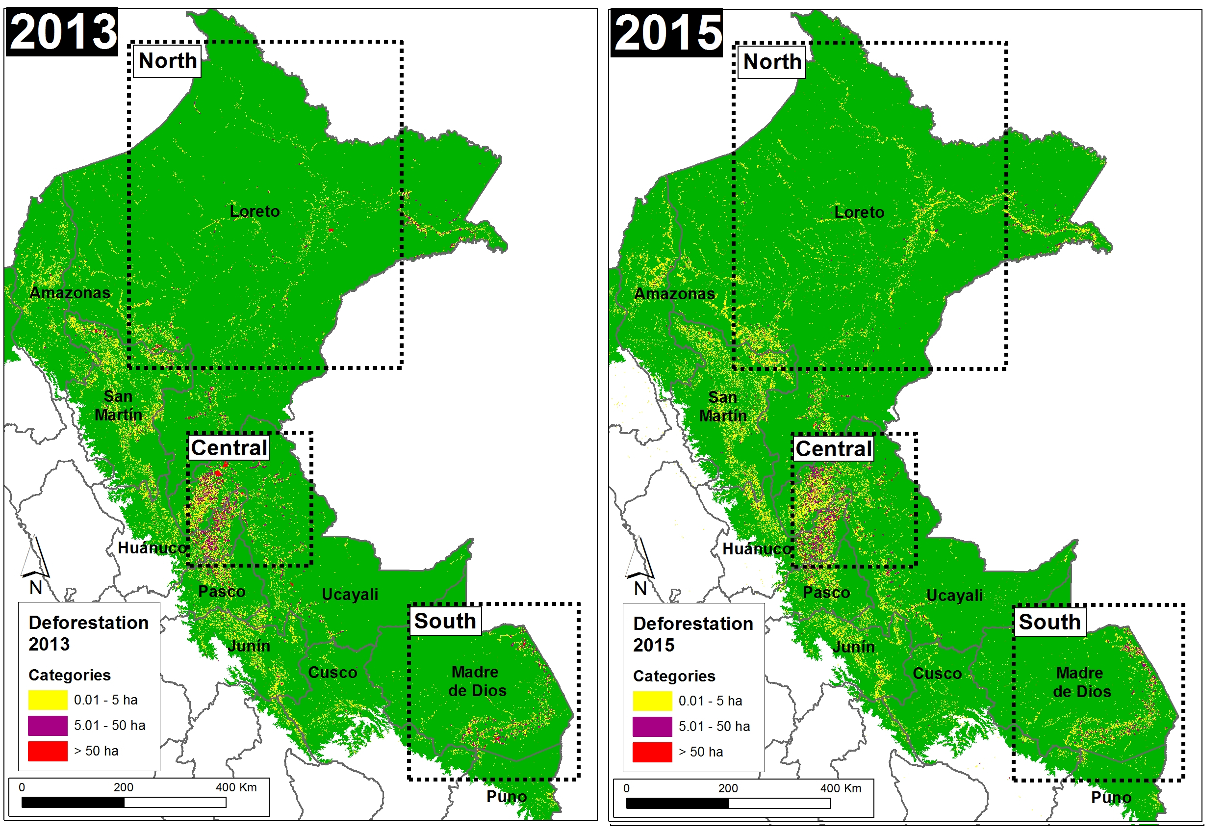
In the previous MAAP #25 and MAAP #26, we illustrated deforestation hotspots in the Peruvian Amazon for the periods 2012-2014 and 2015*, respectively. Here in MAAP #32, we present a complementary analysis based on the size of deforestation events.

Graph 32a shows the comparative results of deforestation patterns between 2013 and 2015, indicating that:
Small-scale (< 5 hectares) accounted for the vast majority of deforestation events (70-80%) each year.
Medium-scale (5-50 hectares) accounted for approximately 20% of the deforestation events each year.
Large-scale (> 50 hectares) deforestation was variable. In 2013, the year with the most activity of new cacao and oil palm plantations, it accounted for 8% of the deforestation events. In 2015 it was only 1%.

In summary, small- and medium-scale deforestation events represent more than 90% of the total and a constant threat, while large-scale deforestation events represents a latent threat. As described below, large-scale projects can quickly cause massive deforestation events, and should therefore remain a high priority.

*We have increased our deforestation estimate for 2015 to 163,238 hectares (403,370 acres), the second highest on record (behind only 2014). This estimate is based on GLAD alerts, produced by University of Maryland, Google, and Global Forest Watch.

Base Map

Image 32a shows, in graphic form, the deforestation patterns described above for 2013 (left panel) and 2015 (right panel). Further below, we show zooms for three key zones in the north, central, and south, respectively.

Categ_13_15_v1_en
Image 32a. Data: PNCB/MINAM, UMD/GLAD

Northern Peruvian Amazon

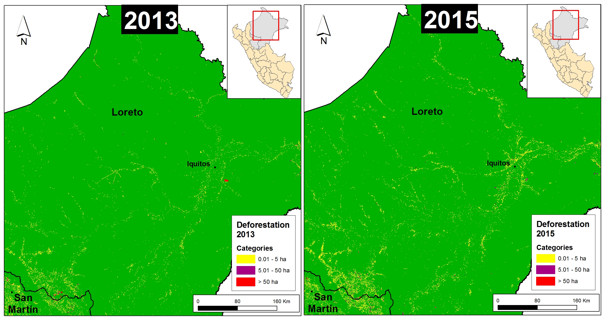
Image 32b shows a zoom of the northern Peruvian Amazon for 2013 (left panel) and 2015 (right panel). In general, there is a pattern of small-scale deforestation along the rivers of Loreto. Additionally, in 2013, there were large-scale deforestation events for a cacao project located to the southeast of the city of Iquitos (see MAAP #27 for more details) and for oil palm plantations along the border of Loreto and San Martin regions (see MAAP #16 for more details). In 2015, the expansion of deforestation continued in these areas, but at a medium-scale.

Categ_13_15_n_v1_en
Image 32b. Data: PNCB/MINAM, UMD/GLAD

Central Peruvian Amazon

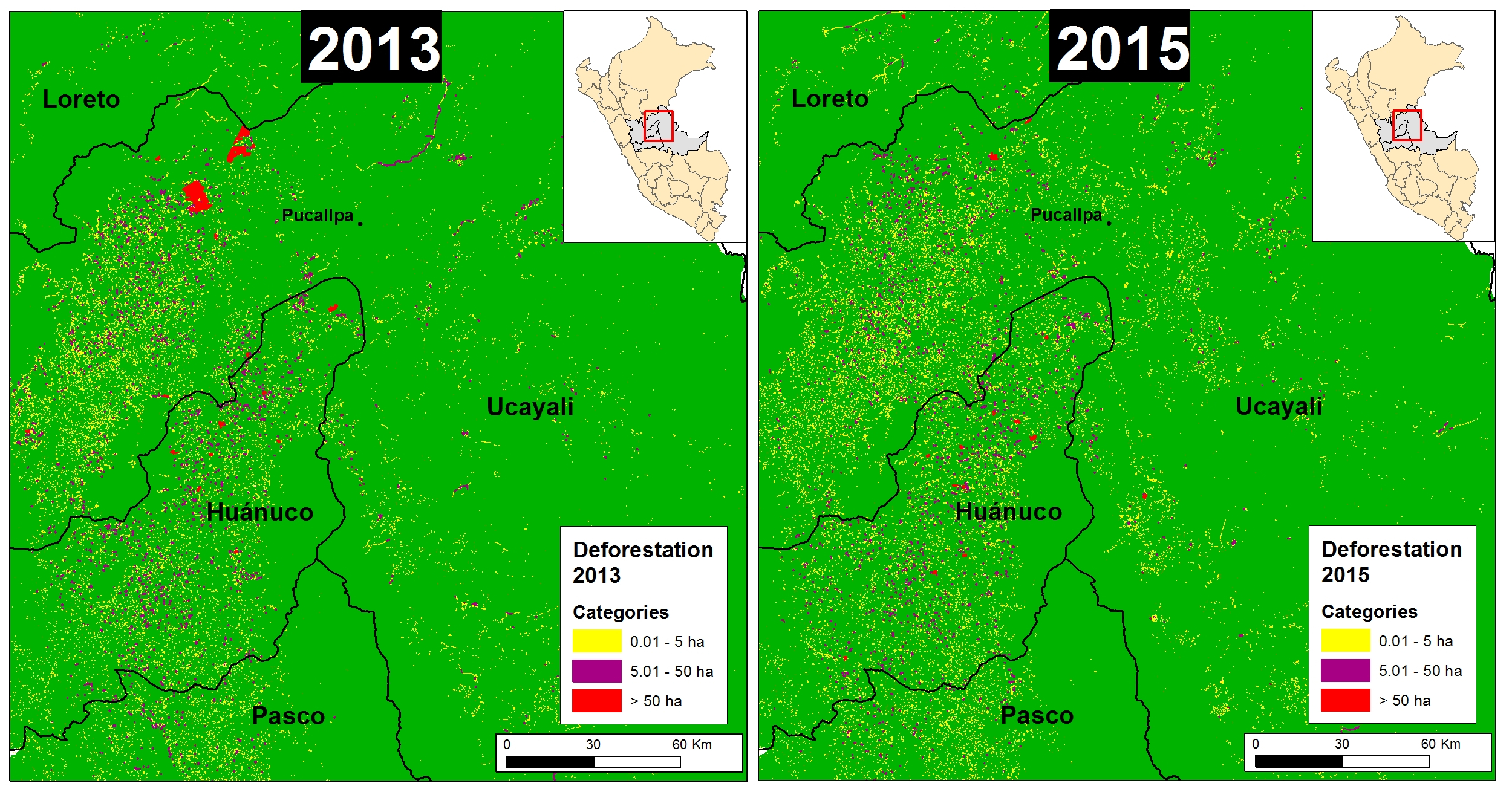
Image 32c shows a zoom of the central Peruvian Amazon for 2013 (left panel) and 2015 (right panel). In general, there is a concentration of small- and medium-scale deforestation between northwest Ucayali and southeast Huánuco. Additionally, in 2013, there is large-scale deforestation for two new oil palm plantations located northeast of the city of Pucallpa (see MAAP #4 for more details).

Categ_13_15_c_v1_en
Image 32c. Data: PNCB/MINAM, UMD/GLAD

Southern Peruvian Amazon

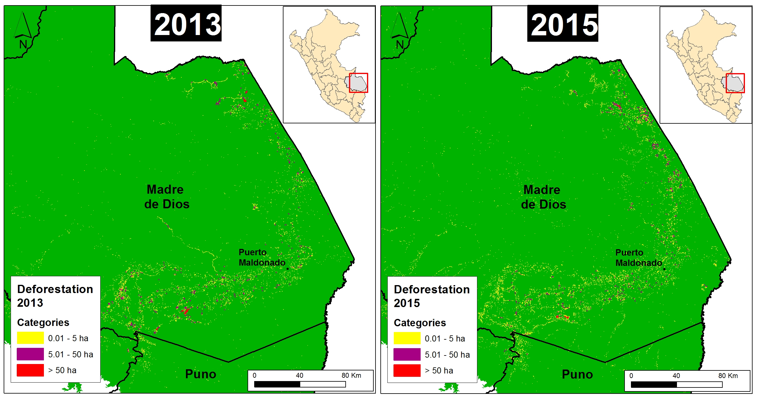
Image 32d shows a zoom of the southern Peruvian Amazon for 2013 (left panel) and 2015 (right panel). In general, there is a pattern of small- and medium-scale deforestation along the Interoceanic highway in Madre de Dios. Additionally, there is the persistence of large-scale deforestation in southern Madre de Dios related to illegal gold mining (see MAAP #12 for more details).

Categ_13_15_s_v1_en
Image 32d. Data: PNCB/MINAM, UMD/GLAD

Citation

Finer M, Novoa S (2016) Large-scale vs. Small-scale Deforestation in the Peruvian Amazon. MAAP: 32.

MAAP #18: Proliferation of Logging Roads in the Peruvian Amazon

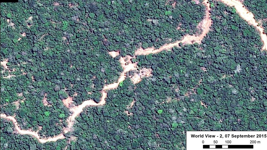
MAAP articles #3 and #15 detailed the construction of several new logging roads in the central Peruvian Amazon. Here in MAAP 18, we provide a more comprehensive analysis of the proliferation of logging roads in this section of the Amazon. In Image 18a, we show a high resolution example of a new logging road in this area with active construction during 2015 (see Inset A1 in Image 18c for more context).

new18a v2
Image 18a. New logging road in the Peruvian Amazon. Data: WorldView-2 of Digital Globe (NextView).

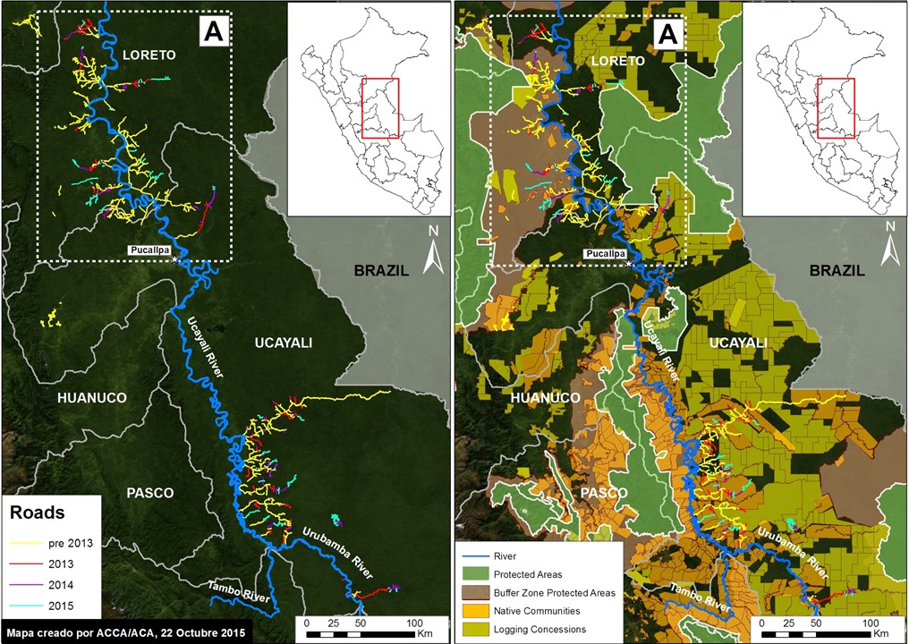
Image 18b illustrates the location of all identified logging roads in the central Peruvian Amazon (southern Loreto and northern Ucayali). Most of these roads are located along the Ucayali River and its headwater tributaries. The left panel highlights just the logging roads, while the right panel also includes protected areas, native communities, and logging concessions.

Image 18b. Logging roads in the central Peruvian Amazon. Data: SERNANP, IBC, USGS, MINAGRI.

In Image 18b, we documented the construction of 1,134 km of logging roads between 2013 and 2015 in the central Peruvian Amazon. Of this total, 538 km is in the matrix of logging concessions and native communities in southern Ucayali, 226.1 km is in undesiganted areas in southern Loreto, 210 km is in the buffer zone of Cordillera Azul National Park, and 159 km is around the new Sierra del Divisor National Park.

Note that the buffer zone of Cordillera Azul National Park and surroundings of Sierra del Divisor National Park contain logging concessions and native communities, thus the responsibility of forest authority is the regional government.

Determining the legality of these roads is complex. As the right panel highlights, many of these roads are near logging concessions and native communities, whom may have obtained the rights for logging from the relevant forestry authority (in many cases, the regional government).

Below, we focus on the logging roads in the northern section of Image 18b (see Inset A).

Zoom A: Logging Roads in Southern Loreto/Northern Ucayali

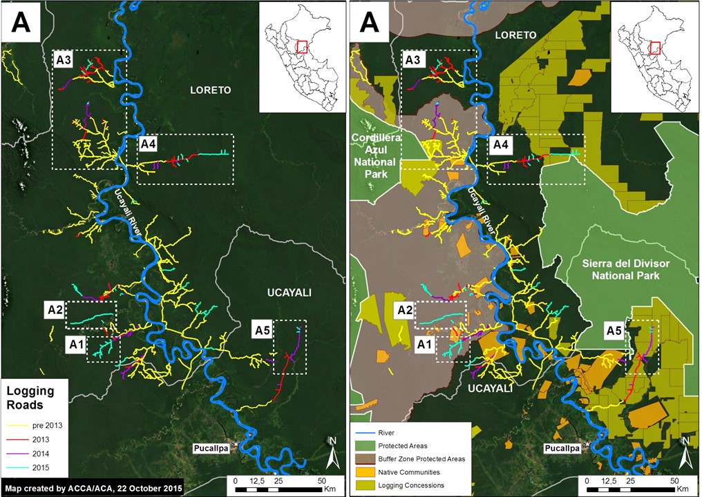
Image 18c. Logging roads in southern Loreto/northern Ucayali. Data: SERNANP, IBC, USGS, MINAGRI.

Image 18c is a zoom of the logging roads shown in the northern section of Image 18a (Inset A), located in southern Loreto and northern Ucayali. It shows five primary areas of interest. Both Insets A1 and A2 correspond to new roads within the southeast buffer zone of the Cordillera Azul National Park with active construction in 2015 (see below for more details).

Insets A3, A4, and A5 correspond to roads with active construction between 2013 and 2015 that have already been featured on MAAP. Inset 3 includes a logging road in the northeast sector of the buffer zone of Cordillera Azul National Park (see MAAP #3 for more details). Insets 3 and 5 show logging roads around the new Sierra del Divisor National Park (see MAAP #15 and MAAP #7 for more details).

Zoom A1: Logging Roads in Nuevo Irazola

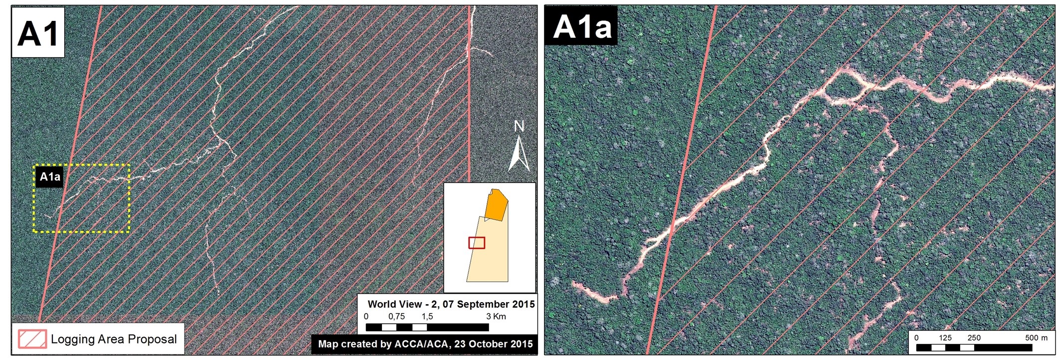
Image 18d provides more details about a new logging road with very recent construction within the southeast buffer zone of Cordillera Azul National Park (See Inset A1 in Image 18C for context). This road has grown 68 km between 2013 and 2015, with more than half of this construction occurring over the past year. According to information obtained from the forestry department within the Regional Government of Ucayali (PRMRFFS), the native community of Nuevo Irazola made a logging permission request for industrial and/or commercial use and prepared an Annual Operating Plan. However, a high-resolution (0.5 m) image shows a recent stretch of the road exceeds the area requested for forestry activities (see Image 18d).

MAAP_Ucayali_roads_18c_vALYSSA
Image 18d. High-resolution image of a new forest road in the southeast buffer zone of Cordillera Azul National Park. Data: WorldView-2 of Digital Globe (NextView).

Zoom A2: Rapid Expansion of a Logging Road

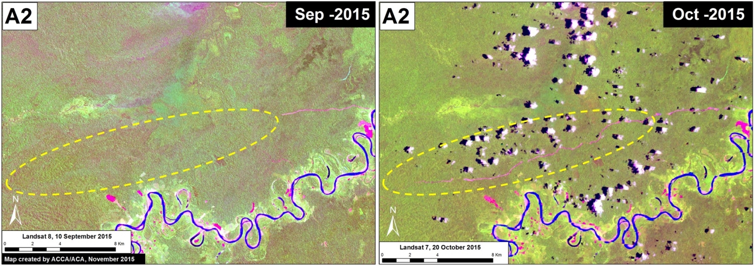
Image 18e. Rapid construction of a forest road in the southeast buffer zone of Cordillera Azul National Park. Data: USGS.
Image 18e. Time series of a forest road in the southeast buffer zone of Cordillera Azul National Park. Data: USGS.

Image 18e illustrates the rapid expansion of another forest road located in the southeast section of the Cordillera Azul National Park buffer zone (See Inset A2 in Image 18C for context). We documented the construction of 29.1 km during the six weeks between September 10 (left panel) and October 20 (right panel), a rate of nearly five kilometers per week. The legality of this road is currently unknown, but note that it is extending in the direction of a forestry concession.

Citation

Novoa S, Fuentes MT, Finer M, Pena N, Julca J (2015) Proliferation of Logging Roads in the Peruvian Amazon. MAAP #18.

Note: MAAP #18 is a collaborative effort between Amazon Conservation Association (ACA), Conservación Amazónica (ACCA), and the Centro de Conservación Investigación y Manejo de Áreas Naturales (CIMA).

MAAP Synthesis #1: Patterns and Drivers of Deforestation in the Peruvian Amazon

We present a preliminary analysis of current patterns and drivers of deforestation in the Peruvian Amazon. This analysis is largely based on the first 15 articles published on MAAP between April and September 2015, but also incorporates information from other relevant sources. We describe this analysis as preliminary because as MAAP research continues, we will be able to improve and refine our synthesis in subsequent editions.
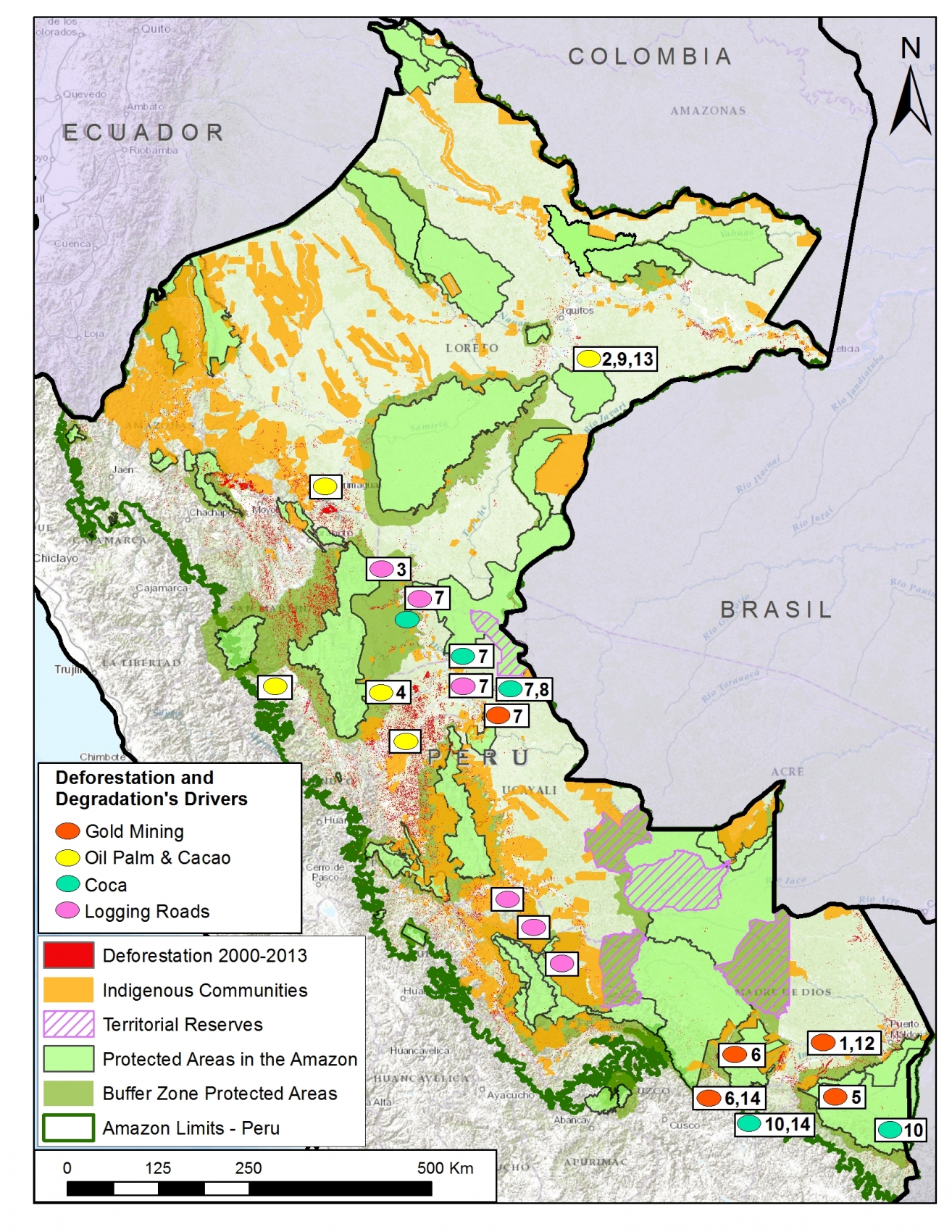
MAAP_Synthe_Sa_v4_en
Image S1a. Recent patterns and drivers of deforestation in the Peruvian Amazon. Numbers indicate relevant MAAP article. Data: SERNANP, IBC, MINAM-PNCB/MINAGRI-SERFOR, MAAP.

Introduction & Summary of Key Results

Image S1a illustrates recent (2000 – 2013) patterns of deforestation in the Peruvian Amazon based on data from the Peruvian Ministries of Environment[i] and Agriculture[ii]. These two Ministries have documented a total forest loss of around 1.65 million hectares (ha) in the Peruvian Amazon between 2001 and 2014, with an increasing trend in recent years (2014 had the highest forest loss on record with 177,571 ha)[iii],[iv]. Another recent report by the Peruvian government stated that the majority (75%) of the Amazonian deforestation is due to small-scale clearings related to agriculture and livestock activities, usually near roads or rivers[v].

Building off of that historical and annual information, our goal at MAAP is to monitor deforestation in near real-time. Since April 2015, we have published numerous articles analyzing areas in the northern, central, and southern Peruvian Amazon. In this initial analysis, we have found that three of the most important drivers of deforestation are large-scale oil palm (and cacao) plantations, gold mining, and coca cultivation. We also found a growing network of logging roads that contribute to forest degradation. Image S1a displays the general geographic distribution of these drivers of deforestation and degradation.

We estimate that around 30,000 hectares of primary forest was cleared since 2000 for large-scale oil palm and cacao plantations. Cacao has recently joined oil palm as a deforestation driver due to the arrival of the company United Cacao and their implementation of the large-scale agro-industrial model in place of traditional small-scale plantations on previously degraded lands.

Gold mining has directly caused the deforestation of over 43,000 ha since 2000, mostly in the region of Madre de Dios. In recent years, this deforestation has been concentrated in the Tambopata National Reserve buffer zone.

Although coca cultivation is reportedly declining in Peru, we found that it remains a major driver of deforestation, particularly within and around remote protected areas. For example, we documented 143 ha of coca related deforestation within the Sierra del Divisor Reserved Zone, and an additional 2,638 ha related to shifting agricultural cultivation, which includes coca, within and around Bahuaja Sonene National Park.

We also documented a recent expansion of logging roads in the central Peruvian Amazon. This finding is significant because it is difficult to detect selective logging in satellite imagery, but now we can at least detect the roads that indicate that selective logging is taking place in a given area.

We identified some important geographic patterns related to the four drivers described above. For example, large-scale oil palm (and cacao) are concentrated in the northern Peruvian Amazon, while gold mining deforestation has largely been in the south. Coca-driven deforestation appears to be particularly problematic in the southern Peruvian Amazon, but also exists in the north. The construction of new logging roads is currently most active in the central Peruvian Amazon.

The documented deforestation is caused by both illegal and legal means. For the former, there is extensive deforestation from illegal gold mining and coca cultivation. Regarding the latter, oil palm and cacao companies are exploiting loopholes in the Peruvian legal framework that facilitate large-scale deforestation for agricultural projects.

Large-scale Agriculture (Oil Palm and Cacao)
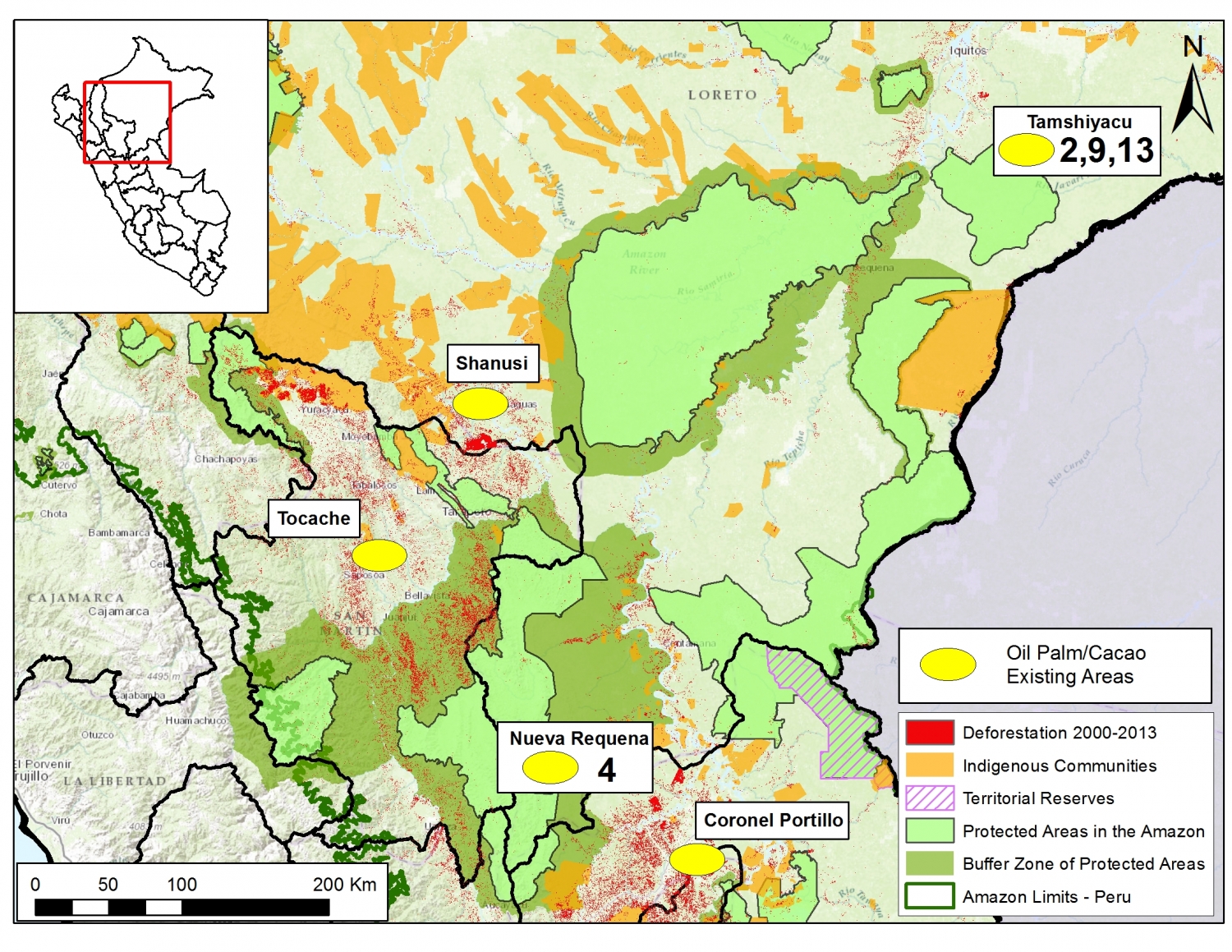
MAAP_Synthe_Sb_v4_en
Image S1b. Large-scale agriculture deforestation in the northern Peruvian Amazon. Numbers indicate relevant MAAP article. Data: SERNANP, IBC, MINAM-PNCB/MINAGRI-SERFOR, MAAP.

Image S1b illustrates that large-scale agriculture (namely oil palm and cacao) is an important cause of deforestation in northern Peru.

Importantly, several oil palm and cacao companies are changing the production model in Peru from small-scale to large-scale agro-industrial. For example, in a recent interview, United Cacao CEO Dennis Melka stated that his company is trying to replicate the agro-industrial model used by oil palm companies in Southeast Asia[vi].

This shift is noteworthy because large-scale plantations usually come at the expense of forests, while small-scale plantations are better able to take advantage of previously cleared lands[vii]. We estimate that over 30,000 hectares of primary forest was cleared since 2000 for large-scale oil palm and cacao plantations (see below). Much less primary forest, around 575 ha, was cleared for small-scale oil palm (we have yet to evaluate small-scale cacao).

Note that we emphasize the clearing of primary forest. We conducted an additional analysis to determine whether oil palm (both small and large-scale) and cacao (just large-scale) plantations were originally sited on lands with primary forest, secondary forest, or already deforested. We defined primary forest as an area that from the earliest available Landsat, in this case 1990, was characterized by dense closed canopy forest cover.

The following is a concise breakdown of how we calculated the 30,000 ha of primary forest loss from large-scale plantations.

MAAP articles #2, #9, and #13 demonstrated that 2,276 ha of primary forest was cleared by United Cacao between May 2013 and September 2015 outside of the town of Tamshiyacu in the northern Peruvian Amazon (Loreto region).

MAAP article #4 detailed the deforestation of 9,400 ha of primary forest (plus an additional 2,350 ha of secondary forest) between 2011 and 2015 for two large-scale oil palm projects near the town of Nueva Requena in the central Peruvian Amazon (Department of Ucayali).

In addition, yet unpublished MAAP analysis shows that in Palmas de Shanusi/Oriente (oil palm projects operated by the company Grupo Palmas), 6,974 ha of primary forest were cleared between 2006 and 2011, although the legally mandated 30% forest cover reserves were maintained. An additional 8,225 ha of primary forest was cleared in areas immediately surrounding the concessions.

Finally, although not yet published on MAAP, we also documented nearly 3,500 ha of primary forest loss in other large-scale oil palm projects in San Martin and Ucayali regions.

It is important to emphasize that several oil palm and cacao companies are exploiting various loopholes in the Peruvian legal framework that facilitate large-scale deforestation for agricultural projects[viii]. In fact, these companies argue that according to Peruvian law, they are engaged in legal “forest clearing”, not illegal “deforestation”[ix].

Gold Mining
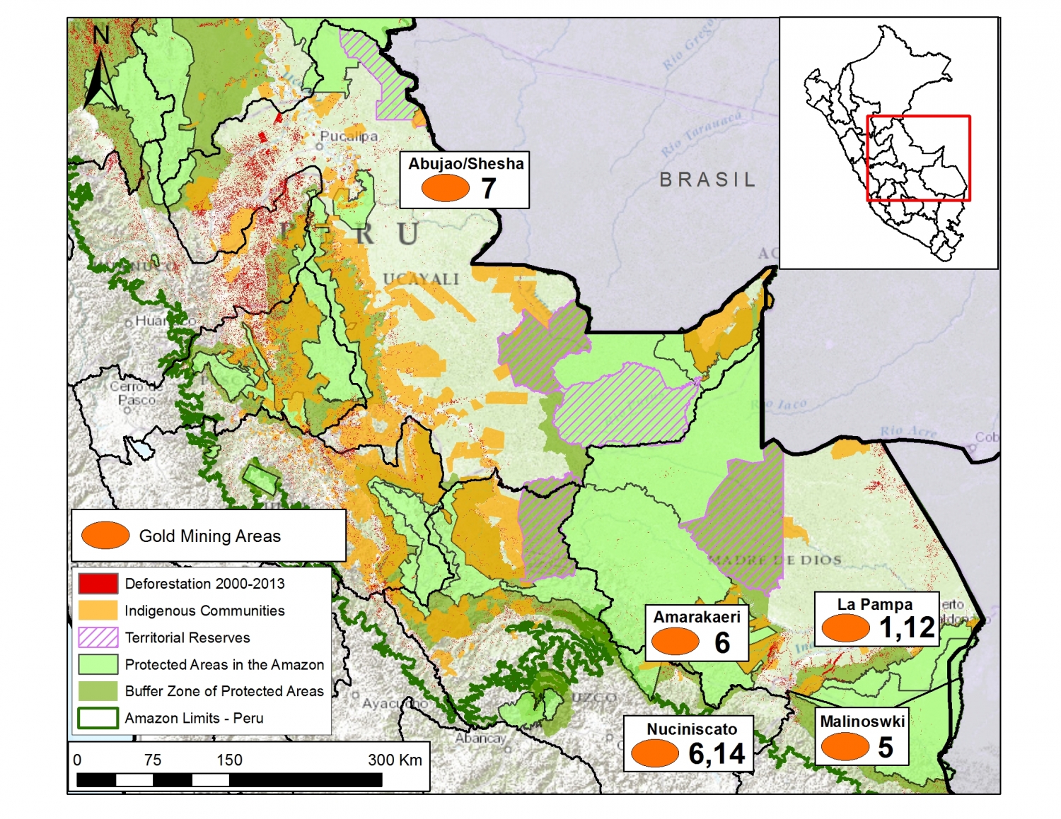
MAAP_Synthe_Sc_v4_en
Image S1c. Gold mining deforestation in the Peruvian Amazon. Numbers indicate relevant MAAP article. Data: SERNANP, IBC, MINAM-PNCB/MINAGRI-SERFOR, MAAP.

Image S1c illustrates that gold mining-driven deforestation is largely concentrated in the southern Peruvian Amazon, particularly in the region of Madre de Dios and adjacent Cusco.

According to the scientific literature, gold mining deforestation in Madre de Dios increased from 10,000 ha in 2000 to 50,000 ha in 2012[x]. MAAP articles #1, #5, and #12 documented the deforestation of an additional 2,774 ha between 2013 and 2015 in two gold mining hotspots (La Pampa and Upper Malinowski), both of which are located within the buffer zone of the Tambopata National Reserve. In addition, MAAP #6 showed gold mining deforestation expanding from another Madre de Dios gold mining hotspot (Huepetuhe) into the tip of Amarakaeri Communal Reserve (11 ha).

Much of the Madre de Dios gold mining deforestation described above is illegal because it is occurring within and around protected areas where mining is not permitted under the government-led formalization process.

MAAP articles #6 and #14 detailed recent gold mining deforestation in the region of Cusco. Specifically, we documented the deforestation of 967 ha along the Nuciniscato River and its major tributaries since 2000 (with the vast majority occurring since 2010). Much of this deforestation appears to be linked to gold mining.

Thus, the total documented gold mining deforestation in Madre de Dios and adjacent Cusco is at least 53,750 ha[xi], over 80% of which has occurred since 2000. This total is an underestimate since we have not yet done detailed studies for 2013 – 2015 deforestation in all of the known gold mining zones in these two regions.

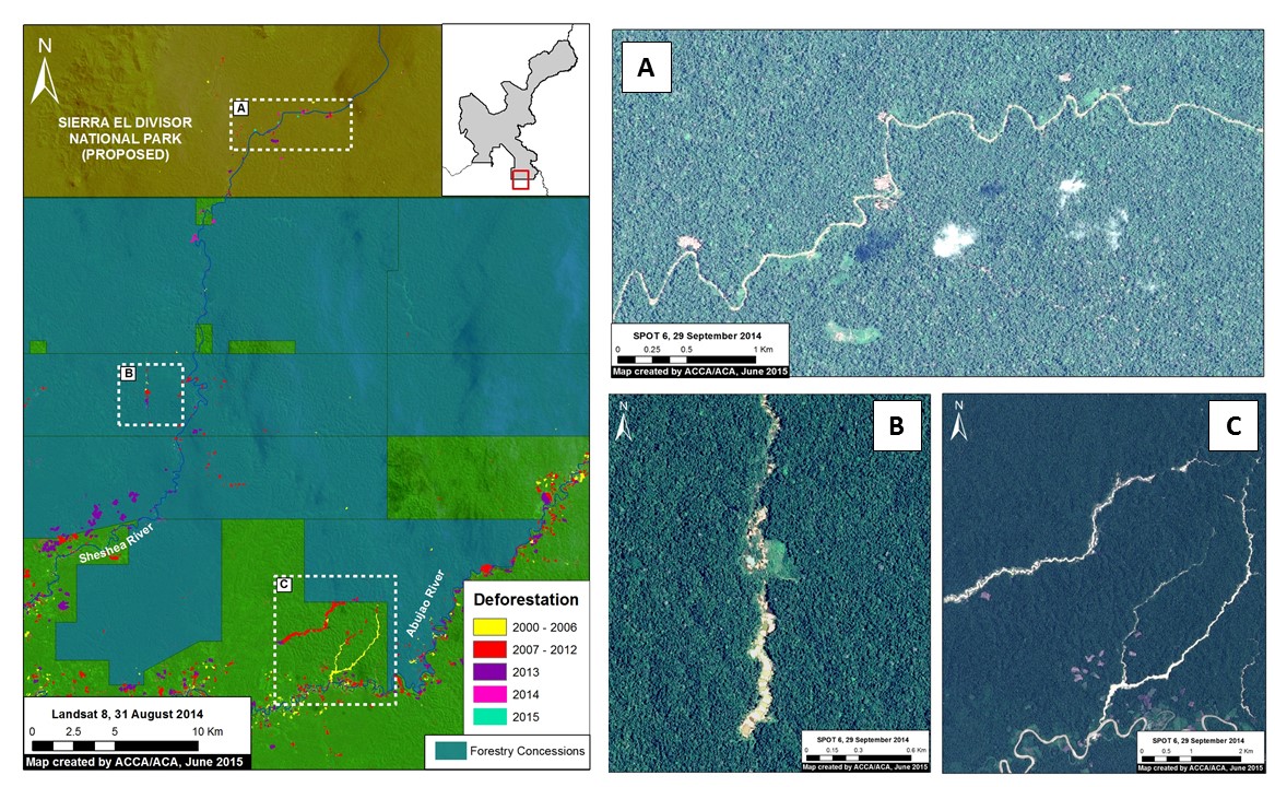
In addition, MAAP #7 showed two gold mining zones in the region of Ucayali (along the Sheshea and Abujao Rivers, respectively). Much of this deforestation occurred between 2000 and 2012.

Finally, there are also reports of extensive gold mining in northern Peru (the regions of Amazonas and Loreto) but we do not yet have data showing that it is causing deforestation.

Coca
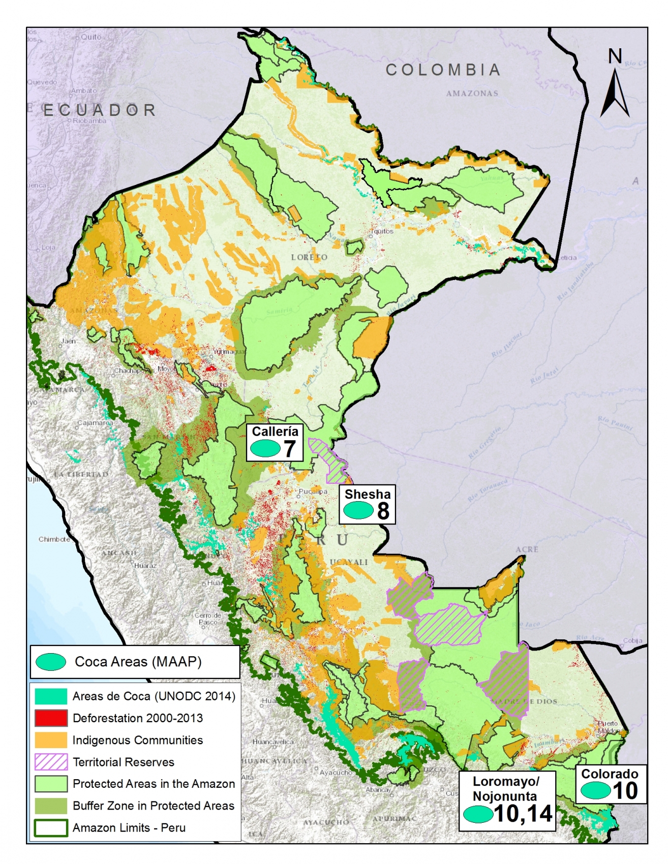
MAAP_Synthe_Sd_v4_en
Image S1d. Coca cultivation areas in the Peruvian Amazon. Numbers indicate relevant MAAP article. Data: UNODC 2014, MINAM-PNCB/MINAGRI-SERFOR, SERNANP, NatureServe.

Although the most recent report from the United Nations Office on Drugs and Crime (UNODC) indicates that overall coca cultivation is declining in Peru[xii], our research finds that it remains a major driver of deforestation in certain areas, particularly within and around several remote protected areas.

Image S1d displays the distribution of current coca-cultivation areas (in relation to protected areas) based on the data from the latest United Nations report. Of these areas, we have thus far focused on the three detailed below.

MAAP articles #7 and #8 show recent coca-related deforestation within the southern section of the Sierra del Divisor Reserved Zone. This area is particularly important because it is soon slated to be upgraded to a national park. Specifically, we documented coca-related deforestation of 130 ha between 2013 and 2014 within the southwestern section of the reserve, and, most recently, a new plantation of 13 ha during June 2015 within the southeast section.

MAAP article #10 revealed that shifting agricultural cultivation, that includes coca, is also a major issue within and around Bahuaja Sonene National Park, located in the southern Peruvian Amazon. Specifically, we found the recent deforestation of 538 hectares within the southern section of the Park, and an additional 2,100 hectares in the surrounding buffer zone. Much of this deforestation is likely linked to coca cultivation since the latest United Nations report indicates these areas contain high coca plantation densities.

MAAP article #14 documents the deforestation of 477 ha along the Nojonunta River in Cusco since 2000 (with a major peak since 2010). Much of this deforestation is likely linked to coca cultivation since the latest United Nations report indicates these areas contain medium to high coca plantation densities. 

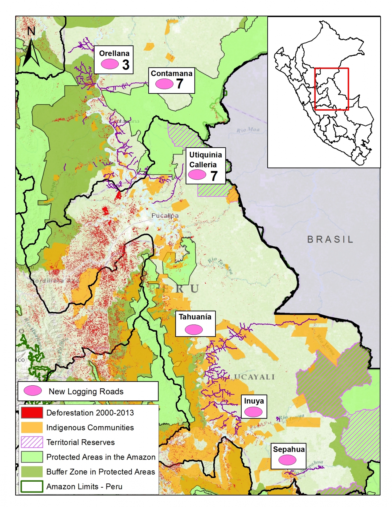
Logging Roads
MAAP_Synthe_Se_v4_en
Image S1e. Logging roads in the Peruvian Amazon. Numbers indicate relevant MAAP article. Data: SERNANP, IBC, MINAM-PNCB/MINAGRI-SERFOR, MINAGRI, MAAP.

One of the major advances discovered in this work is the ability to identify the expansion of new logging roads. This advance is important because it is extremely difficult to detect illegal logging in satellite imagery because loggers in the Amazon often selectively cut high value species and do not produce large clearings. But now, although it remains difficult to detect the actual selective logging, we can detect the roads that indicate that selective logging is taking place in that area.

Image S1e illustrates the likely logging roads that we have recently detected. Of these areas, we have thus far focused on the two detailed below.

MAAP article #3 shows the rapid proliferation of two new road networks in the northern Peruvian Amazon (Loreto region). Most notably, it highlights the construction of 148 km of new roads, possibly illegal logging roads, through mostly primary forest between 2013 and 2014. One of the roads is within the buffer zone of the Cordillera Azul National Park.

In addition, MAAP article #7 shows the expansion of new logging roads near both the southern and northwestern sections of the Sierra del Divisor Reserved Zone. In both cases, the expansion is very recent (between 2013 and 2015).


[i] National Program of Forest Conservation for the Mitigation of Climate Change – PNCB.

[ii] Servicio Nacional Forestal y de Fauna Silvestre – SERFOR

[iii] MINAGRI-SERFOR/MINAM-PNCB (2015) Compartiendo una visión para la prevención, control y sanción de la deforestación y tala ilegal.

[iv] Note that some of the documented forest loss may come from natural causes, such as landslides or meandering rivers.

[v] MINAM (2013) Fondo Cooperativo Para El Carbono de los Bosques (FCPF) Plantilla de Propuesta para la Fase de Preparación para REDD+ (Readiness Plan Proposal – RPP). Link: http://www.minam.gob.pe/cambioclimatico/wp-content/uploads/sites/11/2014/03/R-PP-Per%C3%BA-Final-Dec-2013-RESALTADO_FINAL_PUBLICADA-FCPF_24-febrero.pdf

[vi] NF Joan (2015) United Cacao replicates Southeast Asia’s plantation model in Peru, says CEO Melka. The Edge Singapore.Link: http://www.unitedcacao.com/images/media-articles/20150713-the-edge-united-cacao.pdf

[vii] Gutiérrez-Vélez VH, DeFries R, Pinedo-Vásquez M, et al. (2011) High-yield oil palm expansion spares land at the expense of forests in the Peruvian Amazon. Environ. Res. Lett., 6, 044029. Link: http://iopscience.iop.org/article/10.1088/1748-9326/6/4/044029/pdf

[viii] Environmental Investigation Agency (2015) Deforestation by Definition. Washington, DC. Link: http://eia-global.org/news-media/deforestation-by-definition

[ix] Tello Pereyra R (2015) Situacion legal, judicial, y administrativa de  Cacao del Peru Norte SAC. Link: https://www.youtube.com/watch?v=p_YIe70u1oA

[x] Asner GP, Llactayo W, Tupayachia R, Ráez Luna E (2013) PNAS 110 (46) 18454-18459. Link: http://www.pnas.org/content/110/46/18454.abstract

[xi] That is, 50,000 ha from the literature and 3,750 ha from MAAP analysis.

[xii] UNODC (2015) Monitoreo de cultivos ilícitos Perú 2014. Link: https://www.unodc.org/documents/crop-monitoring/Peru/Peru_Informe_monitoreo_coca_2014_web.pdf

Citation

Finer M, Novoa S (2015) Patterns and Drivers of Deforestation in the Peruvian Amazon. MAAP Synthesis #1. Link: https://www.maapprogram.org/2015/09/maap-synthesis1/
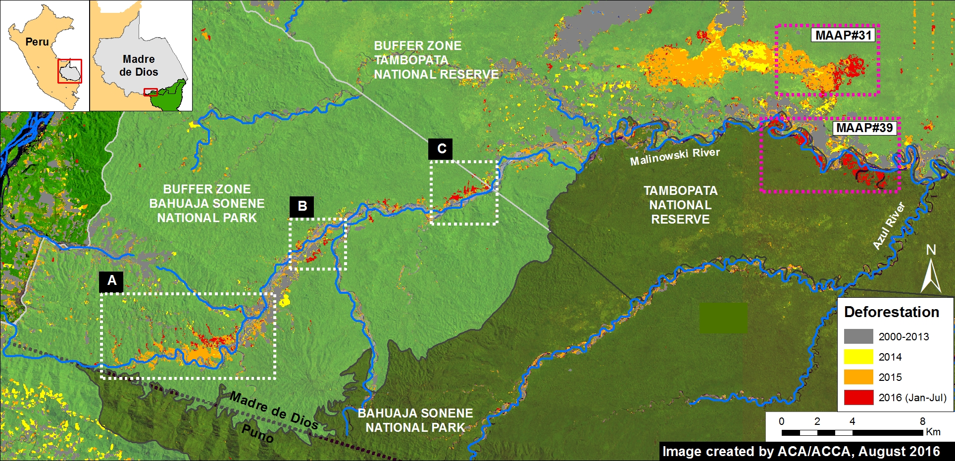
Image #15: Sierra del Divisor – New logging road threatens northern section of proposed national park

In MAAP #7, we emphasized the need to promote the Sierra del Divisor Reserved Zone to the category of National Park due to the growing threats within and around the area. Here in MAAP #15, we show how the construction of a new logging road threatens the northwest section of the current Reserved Zone. New high-resolution images reveal that the construction of this logging road has continued to expand in 2015, and now even crosses a corner of the Reserve.

In addition, in anticipation of the upcoming visit of Peruvian President Ollanta Humala to the United Nations in New York to discuss climate change, we present data on the levels of carbon stored in the proposed Sierra del Divisor National Park.

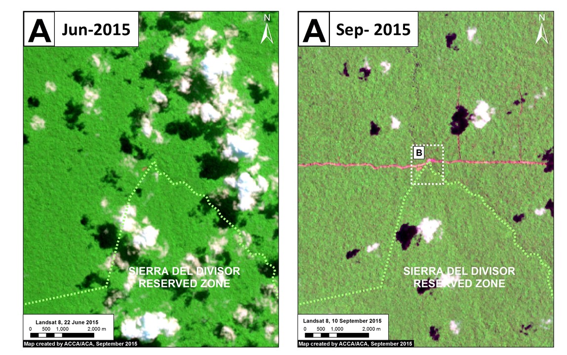
Image 15a. Landsat (30 m res) images of the new logging road crossing the Sierra del Divisor Reserved Zone. Data: USGS, SERNANP

Image 15a shows the most recent expansion of the logging road between June (left panel) and September (right panel) 2015. For more context, note that the area displayed in Image 15a corresponds to the dashed box marked with the letter “A” in Image 15c.

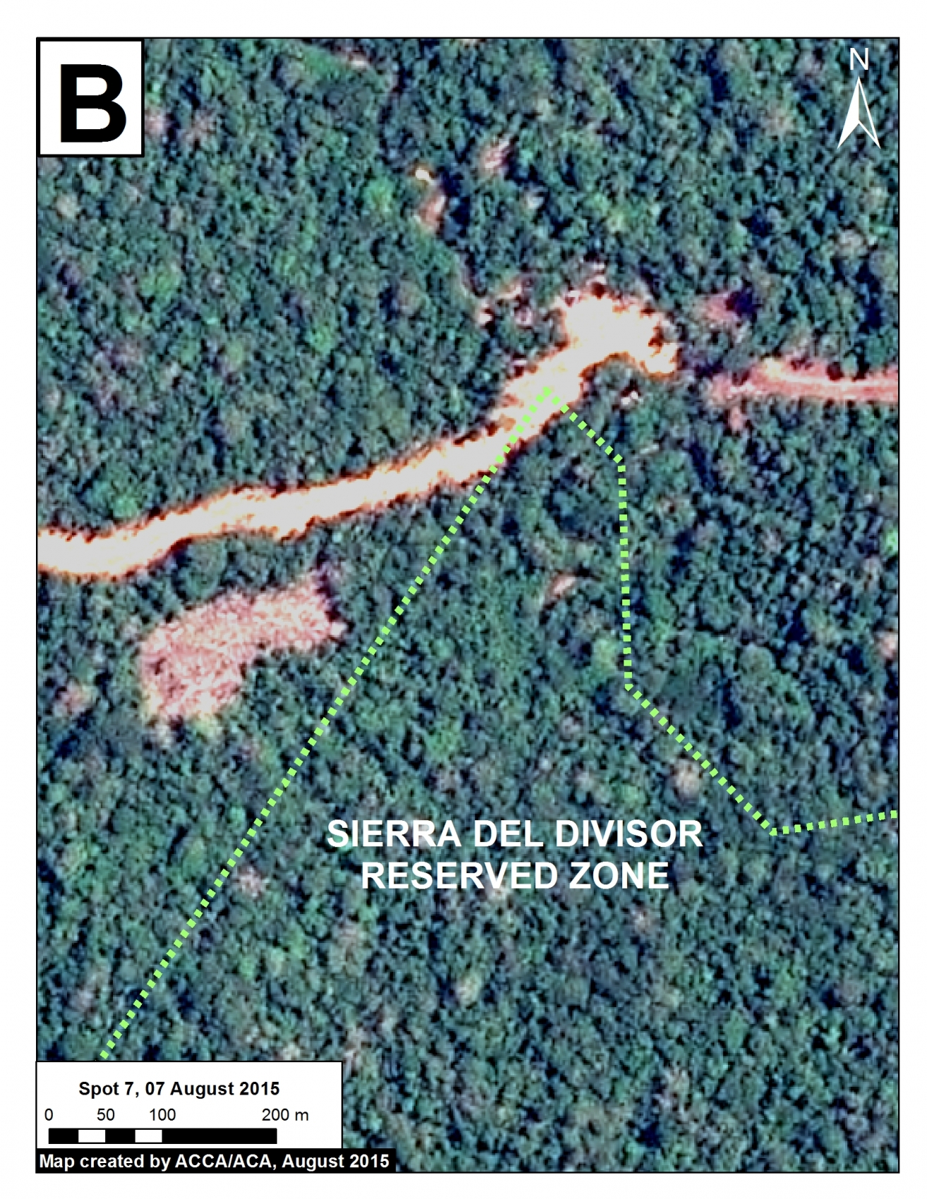
Image 15b displays a high-resolution (1.5 m) image from August 7 of the section of road crossing the northern section of the Sierra del Divisor Reserved Zone.

Image 15b. High-resolution image of logging road crossing northern tip of Reserved Zone. Data: SPOT 7 Airbus.

Expansion 2012 – 2015

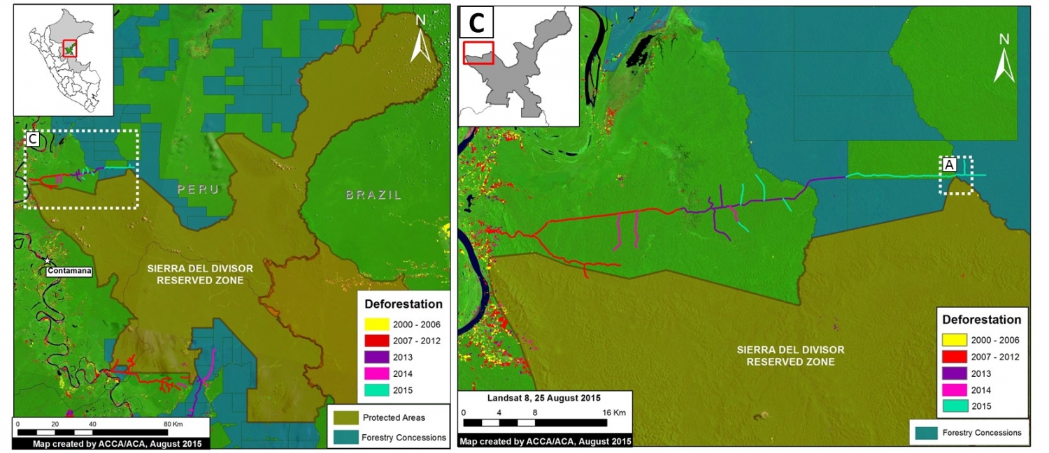
In Figure 15c, we show the expansion of this logging road from 2012 to 2015, totaling approximately 75 km of new road construction during these three years.

Image 15c. Expansion of the logging road in the northeast sector of the Reserve Zone. Data: MINAM-PNCB/MINAGRI-SERFOR, SERNANP, USGS.

Carbon Data

Sierra_divisor_carbom_asner1_e
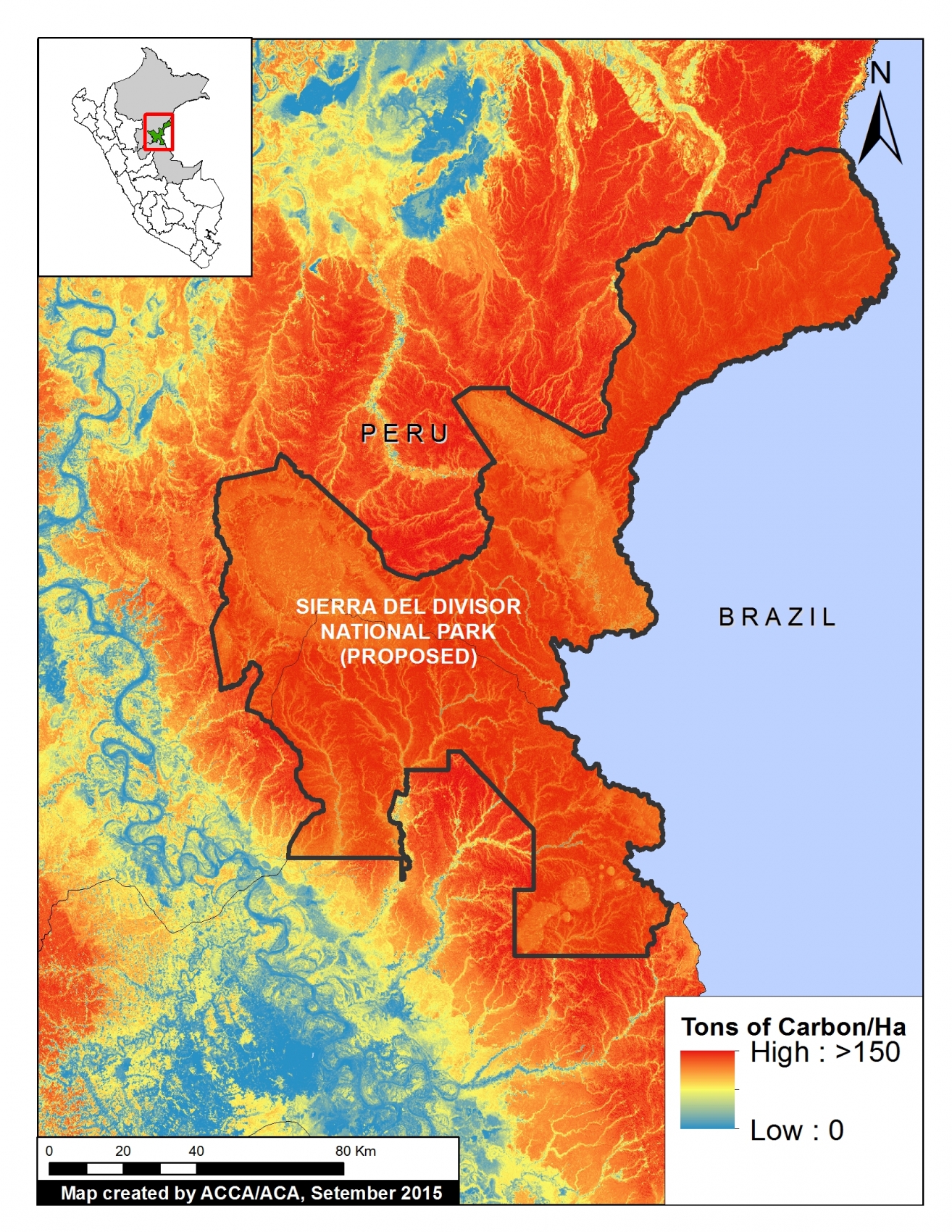
Imagen 15d. High-resolution carbon geography of Sierra del Divisor area. Data: Asner et al. 2014 a,b.


Dr. Greg Asner (from the Carnegie Institution for Science) and colleagues recently produced a high-resolution carbon map of Peru (Asner et al. 2014 a,b).

According to this data, the Sierra del Divisor Reserved Zone has the second largest carbon stock among all Peruvian protected areas (behind only Alto Purus National Park).

As seen in Image 15d, much of the proposed national park area contains high to very high carbon levels. Using this data, we calculated that the proposed Sierra del Divisor National Park contains approximately 165 million metric tons of above-ground carbon.


SERNANP Response

In response to this article, SERNANP (the Peruvian protected areas agency) issued this statement:

The deforestation alert in the northwest sector parallel to the Sierra del Divisor Reserved Zone is caused by the improvement of an alleged older road that runs along the natural protected area, which is being operateded by a neighboring forest concessionaire. We denounced this before the Special Prosecutor for Environmental Matters in Loreto in 2012, as we considered it irregular and a threat to the protected area.

[La deforestación que se advierte en el sector noroeste paralelo a la Zona Reservada Sierra del Divisor se origina por el mejoramiento de una supuesta carretera antigua que viene ejecutando un concesionario forestal colindante con el área natural protegida, la cual denunciamos ante la Fiscalía Especializada de Materia Ambiental – Loreto en el año 2012, por considerarla irregular y constituirse en una amenaza a este espacio protegido.]

This past August, the Special Prosecutor scheduled an inspection, which was conducted jointly with the Public Prosecutor of the Ministry of the Environment. We have been making every effort to ensure that the Special Prosecutor performs the corresponding actions according to law, such as requiring OSINFOR to supervise the forest concessionaire due to the irregular events that we denounced.

[Recién en agosto último la Fiscalía programó la inspección fiscal, que se realizó conjuntamente con la Procuraduría Pública del Ministerio del Ambiente, en la cual venimos realizando todos los esfuerzos para que la Fiscalía Especializada realice las actuaciones que corresponde de acuerdo a Ley, así como requerir al OSINFOR supervise al concesionario forestal, por los hechos irregulares que denunciamos.]

Lima, 17 de setiembre del 2015

References

Asner GP, Knapp DE, Martin RE, Tupayachi R, Anderson CB, et al. (2014 a) Targeted carbon conservation at national scales with high-resolution monitoring. Proceedings of the National Academy of Sciences, 111(47), E5016-E5022.

Asner GP, Knapp DE, Martin RE, Tupayachi R, Anderson CB, et al. (2014 b) The high-resolution carbon geography of Peru. Berkeley, CA: Minuteman Press.

Citation

Finer M, Novoa S (2015) Sierra del Divisor – New logging road crosses northern section of Reserve Zone MAAP: Image #15. Link: https://www.maapprogram.org/2015/09/image15-sierra-divisor/
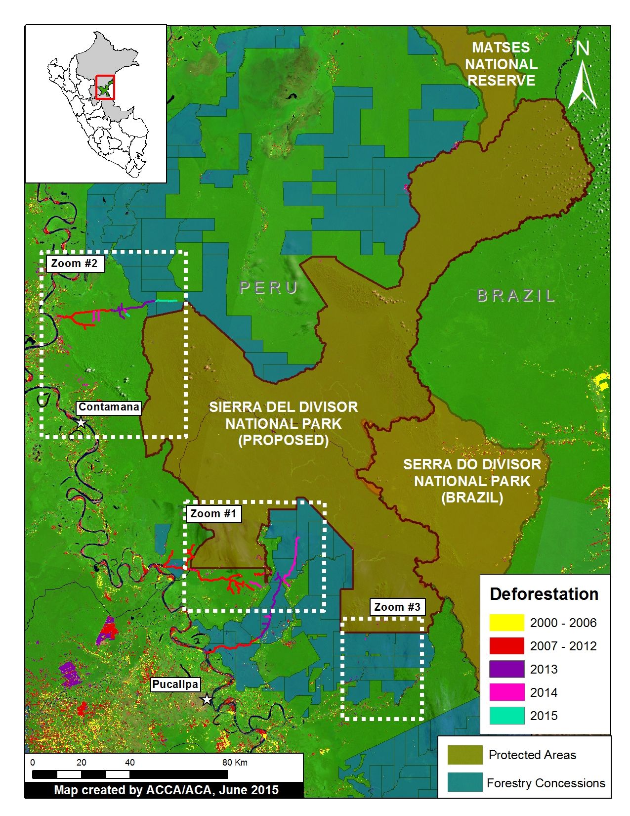
Image #7: Sierra del Divisor – Growing Threats Highlight Importance of Creating National Park

As the Peruvian Government decides whether the Sierra del Divisor Reserved Zone should become a National Park, here in Image of the Week #7 we offer this new analysis of the current deforestation patterns of the area. A Reserved Zone classification, which was applied to Sierra del Divisor in 2006, is a temporary measure to protect an area of biological importance until the government is able to determine a final designation. National Park status represents the strongest possible final designation and would lead to strengthened legal protections to confront the growing array of threats we document below (namely, illegal coca, logging, mining activities).

Sierra_divisor_MAAP_7a_v7_zoomareas
Image of the Week 7a. Deforestation patterns within and around the proposed Sierra del Divisor National Park. Key data sources: MINAM, SERNANP, USGS, IBC, MINAGRI, Hansen/UMD/Google/USGS/NASA.

Key Findings:

We have detected several deforestation fronts within and around the current Sierra del Divisor Reserved Zone. These findings demonstrate the need for the stronger legal protections that would come with National Park status.

Most notably, we detected within and around the current  Reserved Zone (and proposed National Park):

– Deforestation for illegal coca cultivation within the southwestern section (Zoom #1).

– New logging roads near both the southern and northwestern sections (Zooms #1 and #2).

– Deforestation associated with illegal logging camps within the southeastern section (Zoom #3). This illegal logging is within the Isconahua Territorial Reserve, an official land classification designed to protect the territory of indigenous peoples in isolation.

– Gold mining near the southern section (Zoom #3).

Background: From Reserved Zone to National Park

Sierra_divisor_MAAP_7o_v4p
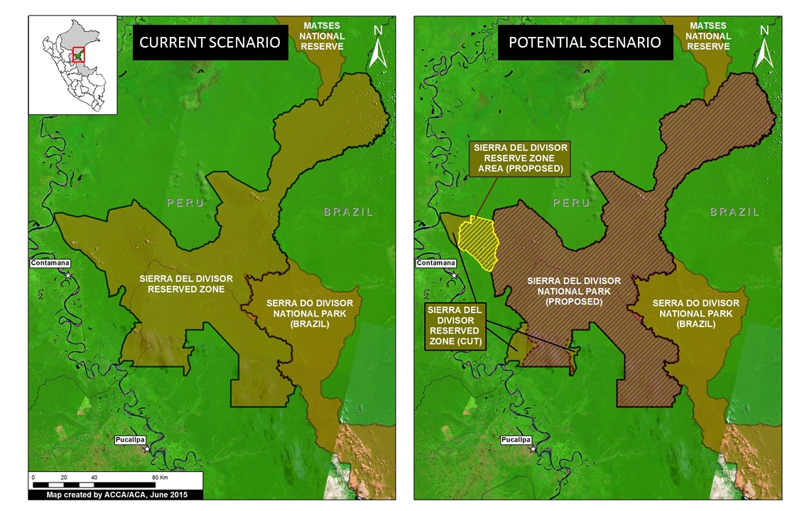
Image 7b. The current (left panel) and potential (right panel) scenario for the Sierra del Divisor region

Image 7b illustrates the current (left panel) and potential (right panel) scenario for the Sierra del Divisor region.

The vast majority of the Reserved Zone would become a National Park under the current proposal pending before the Peruvian government. The proposed Sierra del Divisor National Park covers a vast area (1,354,485 hectares) in the far eastern Peruvian Amazon (departments of Loreto and Ucayali), adjacent to the Brazilian border.

Note that several sections on the western side of the Reserved Zone would not be included, however. Part of the excluded area, in the northwest, will remain as a Reserved Zone and may be part of a future proposal for a Regional Conservation Area known.


Coca and Logging Roads in Southwestern Section (Zoom #1)

Sierra_divisor_MAAP_7b_Zoom1_v5_p
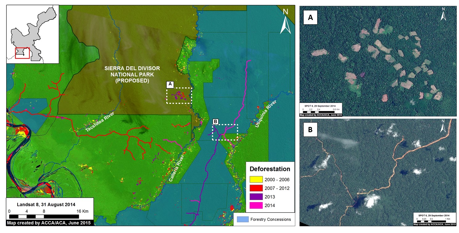
Image 7c. Zoom #1: Enhanced view of the southwestern section of the proposed national park. Panels A and B are high resolution satellite images of the areas indicated on the main map on the left. Key data sources: MINAM, SERNANP, ACCA, Hansen/UMD/Google/USGS/NASA, USGS, SPOT 6.

Image 7c provides an enhanced view of the southwestern section of the proposed National Park. It highlights an expanding deforestation cluster — 130 hectares between 2013 and 2014 — on the upper Calleria River (see “A” on the map). Our analysis indicates that illegal coca cultivation is the cause of this deforestation. Panel A shows a high resolution satellite image of this deforestation.

Also note that a new road is being constructed near the southwestern park boundary (see “B” on the map). We presume it to be a logging road because it passes through a forestry concession. Most notably, there was significant new construction in both 2013 and 2014, indicating that the road is in active use. In addition, high resolution imagery (see panel B) shows road width of about 30 meters, indicating that it may be designed for larger vehicles and heavy machinery.

Logging Road Approaching Northwestern Section (Zoom #2)

Sierra_divisor_MAAP_7c_Zoom2_v4
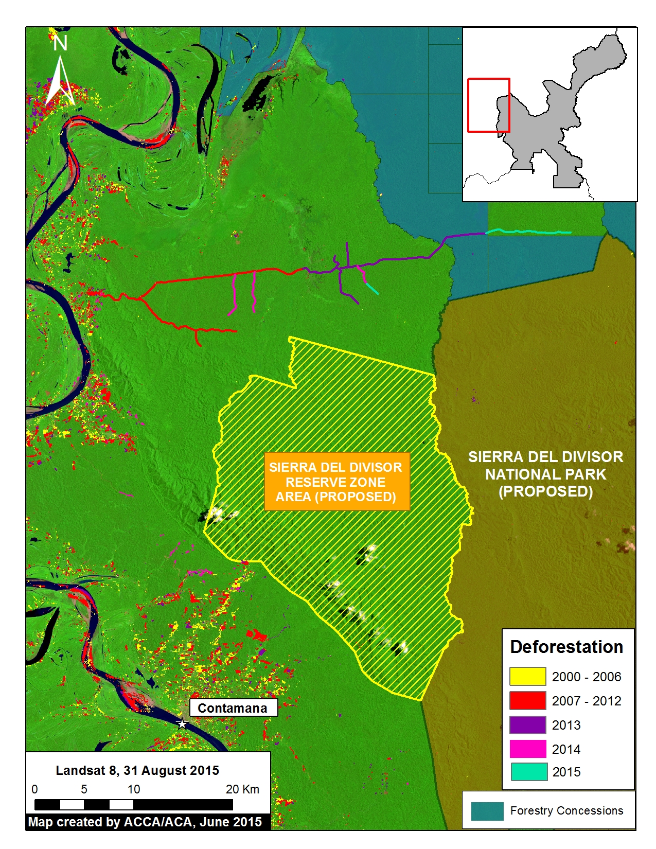
Image 7d. Zoom #2: Enhanced view of the northwestern section of the proposed national park. Key data sources: USGS, SERNANP, GOREL.

Image 7d provides an enhanced view of the northwestern section of the proposed National Park, showing the construction of another new logging road. We presume that it is a logging road because it is passing through forestry concessions with no other obvious destination. Most notably, there was new construction in 2013, 2014, and 2015 indicating that is an active logging road.

Also note the expanding deforestation, especially in 2014, outside of the town of Contamana, indicating the importance of creating a Regional Conservation Area in this area adjacent to the proposed National Park.


Illegal Logging and Gold Mining in Southeastern Section (Zoom #3)

Sierra_divisor_MAAP_7d_Zoom3_v7_p
Image 7e. Zoom #3: Enhanced view of the southeastern section of the proposed national park. Panels A, B, and C are high resolution satellite images of the areas indicated on the main map on the left. Key data sources: MINAM, SERNANP, ACCA, Hansen/UMD/Google/USGS/NASA, USGS, and SPOT 6.

Image 7e provides an enhanced view of the southeastern section of the Proposed National park. It highlights that both illegal logging (see “A” on the map) and gold mining (see “B” and “C” on the map) are present.

It is important to emphasize that this southeast section is part of the Isconahua Territorial Reserve administered by the Ministry of Culture. This is an official land designation in favor of indigenous peoples in isolation, to protect their rights, habitat, and the conditions that ensure their existence and integrity as a people.

Regarding the illegal logging, our analysis indicates the deforestation within the proposed National Park along the upper Shesha River is caused by a series of logging camps. Panel A shows a high resolution satellite image of this deforestation. This illegal logging is within the Isconahua Territorial Reserve.

Regarding the gold mining, there are two principal zones causing deforestation, one along the Shesha River and the other along the Abujao River. Panels B and C show high resolution images of these two mining areas. The headwaters of both river systems are born in the proposed park.

SERNANP Response

In response to this article, SERNANP (the Peruvian protected areas agency) issued this statement:

La Zona Reservada Sierra del Divisor es un espacio de carácter transitorio a cargo del Servicio Nacional de Áreas Naturales Protegidas por el Estado (SERNANP).  La zona aledaña a esta área acoge a 14 Comunidades Nativas, las cuales aprovechan los servicios ecosistémicos en beneficio de más de 500 familias.

En los últimos años la ZRSD ha logrado mejores resultados en su lucha contra la tala ilegal enfrentando esta amenaza sobre todo en espacios de ámbito de las reservas territoriales, y continúa alerta por la deforestación asociada al cultivo ilícito de coca que se reporta en esta parte del país.

En ese marco, se ha reportado desde el 2011 a los sectores correspondientes para su incorporación dentro del Plan Anual de Reducción del Espacio Cocalero de tal forma que se haga frente a esta amenaza de manera estratégica.

Data Description:

Background map is a mosaic of four Landsat 8 images (30 m resolution) from August and September 2014. Any variation of green indicates forest cover. Note there is some scattered cloud cover. Data is from USGS.

Protected areas are darker green. Data for the proposed Sierra del Divisor National Park comes from its technical document (expediente técnico).

Black indicates areas that were deforested as of 2000 according to data from the Peruvian Environment Ministry (MINAM 2009). Yellow (2000-2006), red (2007-2012), and purple (2013) indicate areas that were deforested from 2000 to 2013 according to data published by Hansen et al. 2013 (Science 342: 850–53; Data download).

Pink and teal indicate areas that were deforested between 2014 and early 2015 based on our analysis of Landsat imagery using CLASlite forest monitoring software.

Citation

Finer M, Novoa S (2015) Sierra del Divisor: Growing Threats Highlight Importance of Creating National Park. MAAP Image #7. Link: https://www.maapprogram.org/2015/06/image-7-sierra-del-divisor/

Image #3: Detection of New (Logging?) Roads in the Peruvian Amazon

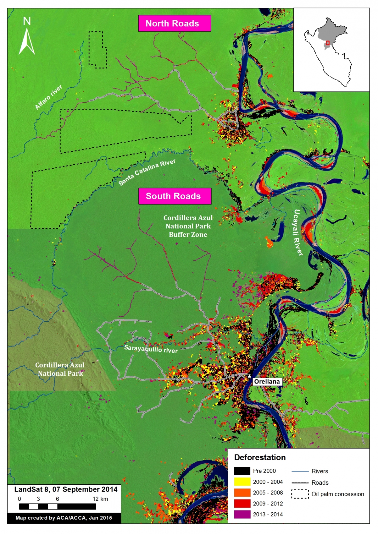
Image of the Week #3 shows the rapid proliferation of two new road networks in the northern Peruvian Amazon (Department of Loreto). Most notably, it highlights the construction of nearly 150 km of new roads, possibly illegal logging roads, through mostly primary forest between 2013 and 2014. One of the roads is within the buffer zone of the Cordillera Azul National Park.

TierraBlanca_MAAP_3a_v4
Image of the Week 3. Detection of new road construction in the northern Peruvian Amazon (Department of Loreto) Key data sources: MINAM, Hansen/UMD/Google/USGS/NASA, USGS, SERNANP, Grupo Palmas, GOREL.

Map Description

Background map is a Landsat 8 image (30 m resolution) from September 7, 2014. Green indicates forest cover. Our analysis has demonstrated that much of this forest cover is primary forestData is from USGS.

Black indicates areas that were deforested as of 2000 according to data from the Peruvian Environment Ministry. Yellow, orange, and red indicate areas that were deforested from 2000 to 2012 (each color covers a four year period) (Hansen MC et al. 2013 Science 342: 850–53; Data download).

Purple indicates areas that were deforested between 2013 and 2014 based on our analysis of Landsat imagery using CLASlite forest monitoring software. Note the two new road networks, labeled North and South, respectively, to the west of the Ucayali River.

Black dashed lines indicate planned oil palm plantations. We obtained this data from Environmental Impact Studies and the Regional Government of Loreto (GOREL).

Protected areas data is from SERNANP. Note the different shades of green to differentiate the protected area and its respective buffer zone.

TierraBlanca_MAAP_3b_v3
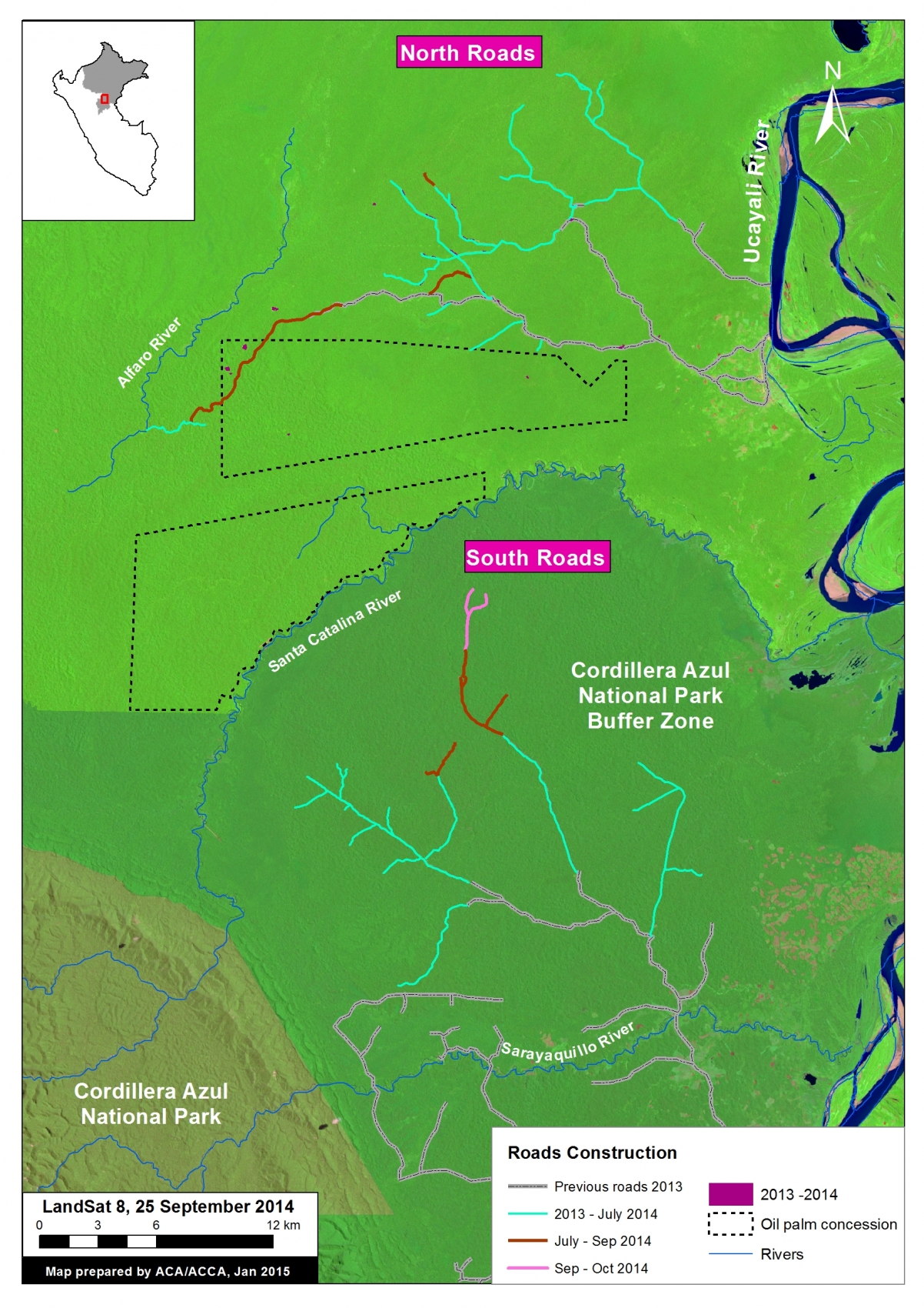
Image 3b. Road construction time-series. Key data sources: USGS, SERNANP, Grupo Palmas.

Construction of New Roads

We color coded the segments of road by construction period: Grey indicates  road segments constructed between 2009 and 2012. Teal indicates road  segments constructed between January 2013 and July 2014 (117.3 km). Dark-orange   indicates road segments constructed between July and September 2014 (25.9  km). Pink indicates road segments constructed between September and October  2014 (4.8 km).

In sum, 148 km of new roads was constructed in this area between January 2013 and  October 2014 (76.24 km in south and 77.38 km in the north).

The southern network is characteristic of a logging road in that it does not have a clear destination and instead just keeps extending and branching deeper into closed-canopy forest.

The northern network is more puzzling in that it crosses a proposed palm oil concession (Grupo Romero’s Tierra Blanca project) and terminates at the Alfaro River. Also note several areas of recent deforestation near the road in the northwest corner of the oil palm concession.


TierraBlanca_MAAP_3c_v3
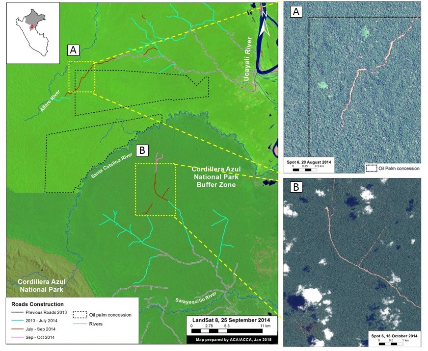
Image 3c. High resolution SPOT 6 images (1.5 m resolution) of portions of the northern and southern road networks. Key data sources: USGS, SPOT 6.

High-resolution zooms

Panel A is a high resolution SPOT 6 image (1.5 m resolution) from August 2014 of a portion of the northern road network.

Panel B is a high resolution SPOT 6 image (1.5 m resolution) from October 2014 of a portion of the southern road network.


Citation

Finer M, Novoa S (2015) Detection of New (Logging?) Roads in the Peruvian Amazon. MAAP: Image #3. Link: https://www.maapprogram.org/2015/04/detection-of-new-road-construction-in-southern-loreto-peru/