MAAP #211: Illegal roads and Deforestation in Indigenous Reserves & National Parks of the Colombian Amazon

Illegal roads are a major threat to the Colombian Amazon, often opening remote primary forests to the main drivers of deforestation: cattle pastures, land grabbing and coca production.

Base Map. Illegal roads causing recent deforestation. Data: MAAP/ACA, FCDS.

These illegal roads threaten protected areas (including national parks) and indigenous territories (known as Resguardos in Colombia).

In 2024, in collaboration with our Colombian partner FCDS, we have documented these impacts in two important areas in the heart of the Colombian Amazon: the Llanos del Yari-Yaguara II Indigenous Reserve and the adjacent Chiribiquete National Park (see Base Map).

Most notably, in the Llanos del Yari-Yaguara II Indigenous Reserve, we see the construction of a new road, causing massive deforestation of primary forests, both within and adjacent to the territory (856 hectares, or 2,115 acres, in total).

In Chiribiquete National Park, we see the expansion of deforestation of 64 hectares (158 acres) along an illegal road penetrating the northwest sector of this important protected area.

Below, we show satellite images for both cases.

Llanos del Yari- Yaguara II Indigenous Reserve

Since March 2023, a new 14-kilometer illegal road has been built in this area, of which 5.3 km is within the northeastern sector of the Llanos del Yari- Yaguara II Indigenous Reserve, located in the department of Guaviare. Figures 1 and 2 show that this construction has caused massive deforestation: 856 hectares (2,115 acres), of which 394 hectares are within the Reserve, between February 2023 (left panel) and March 2024 (right panel). This deforestation is presumably for new cattle pasture, facilitated by the new road. Note that Figure 1 shows the satellite images without markings, while Figure 2 adds markings for the illegal road construction and associated deforestation.

Figure 1. Deforestation along the new illegal road in the Llanos del Yari- Yaguara II Indigenous Reserve, without markings. Data: Planet, NICFI.
Figure 2. Deforestation along the new illegal road in the Llanos del Yari- Yaguara II Indigenous Reserve, with markings. Data: Planet, NICFI.

Chiribiquete National Park

In the adjacent northwest sector of Chiribiquete National Park, deforestation continues to expand along an existing illegal road, known as the Tunia-Ajaju road, located in the department of Caquetá. Figures 3-6 show the deforestation of 64 hectares (56 hectares in zone B and 8 hectares in zone C) along this road inside the national park, between March 2023 (left panel) and March 2024 (panel right). This deforestation is presumably for new cattle pastures, facilitated by the road. Note that Figures 3 and 5 show the satellite images without markings, while Figures 4 and 6 add markings for the illegal road construction and associated deforestation.

Figure 3. Deforestation along the new illegal road in Chiribiquete National Park (zone B), without markings. Data: Planet, NICFI.
Figure 4. Deforestation along the new illegal road in Chiribiquete National Park (zone B), with markings. Data: Planet, NICFI.
Figure 5. Deforestation along the new illegal road in Chiribiquete National Park (zone C), without markings. Data: Planet, NICFI.
Figure 6. Deforestation along the new illegal road in Chiribiquete National Park (zone C), with markings. Data: Planet, NICFI.

Citation

Finer M, Ariñez A (2024) Illegal roads and Deforestation in Indigenous Reserves & National Parks of the Colombian Amazon. MAAP: 211.

 

MAAP #207: Removing Illegal Mining from Sacred Tepui in Yapacana National Park (Venezuelan Amazon)

Last year,  in collaboration with the organization SOS Orinoco, we published an urgent report about illegal mining on top of a sacred tepui in the heart of Yapacana National Park in Venezuela (MAAP #169).
Tepuis are stunning table-top mountains found in northern South America. They are considered sacred by indigenous groups of the region; in fact, the word tepui means “house of the gods” in a local indigenous language. Tepuis also have high levels of endemism (unique species) since they are not connected to other ranges.

In that report, we documented 425 illegal mining data points (consisting of mining camps and machinery) on top of the tepui, indicating an organized and large-scale operation on top of this critically important biogeographical site.

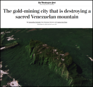
Given the importance of this finding, the Washington Post published a high-profile article on the subject (see right), further exposing the severity of the illegal mining on the tepui.

In response, the Venezuelan government conducted a military operation (led by the Operational Strategic Commander of the Armed Forces) against illegal mining activity on the tepui in December 2022.

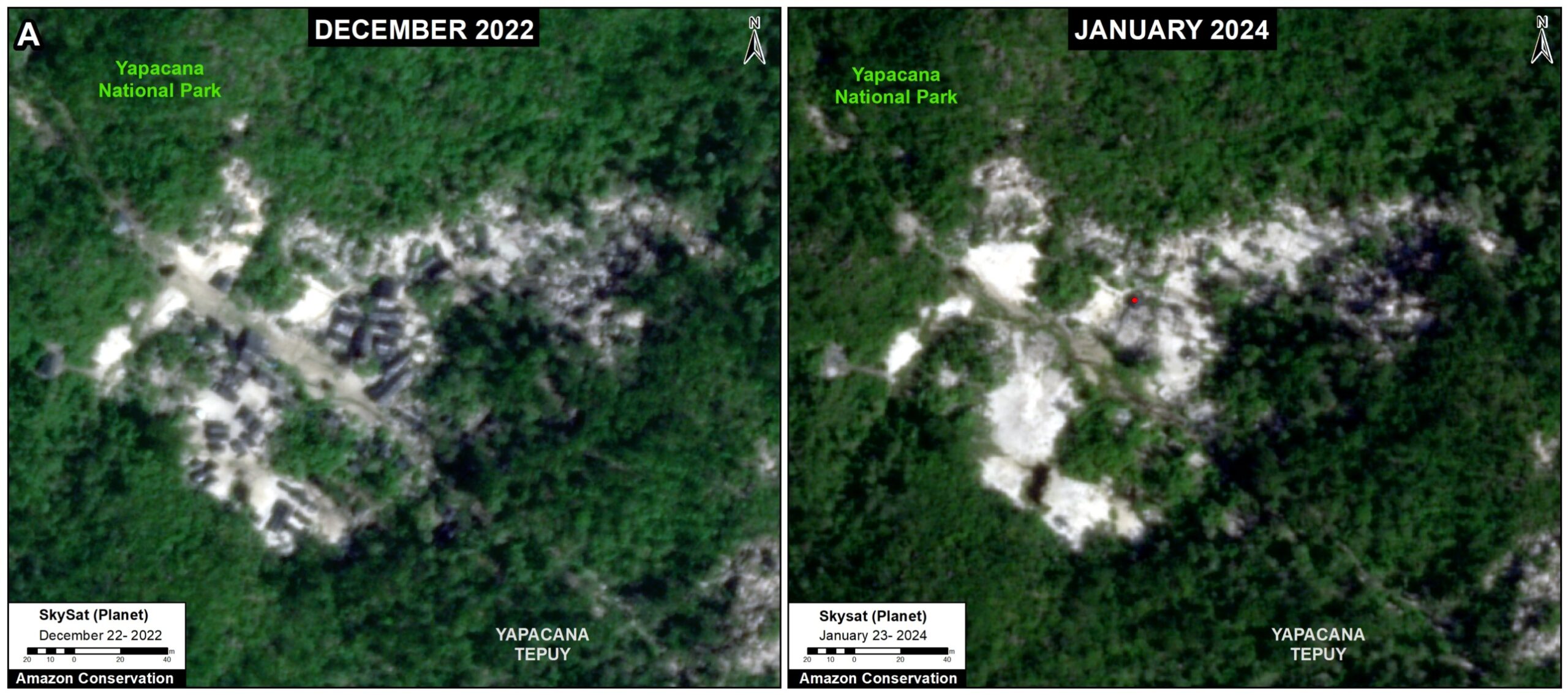
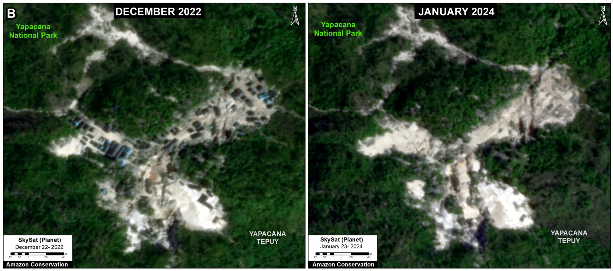
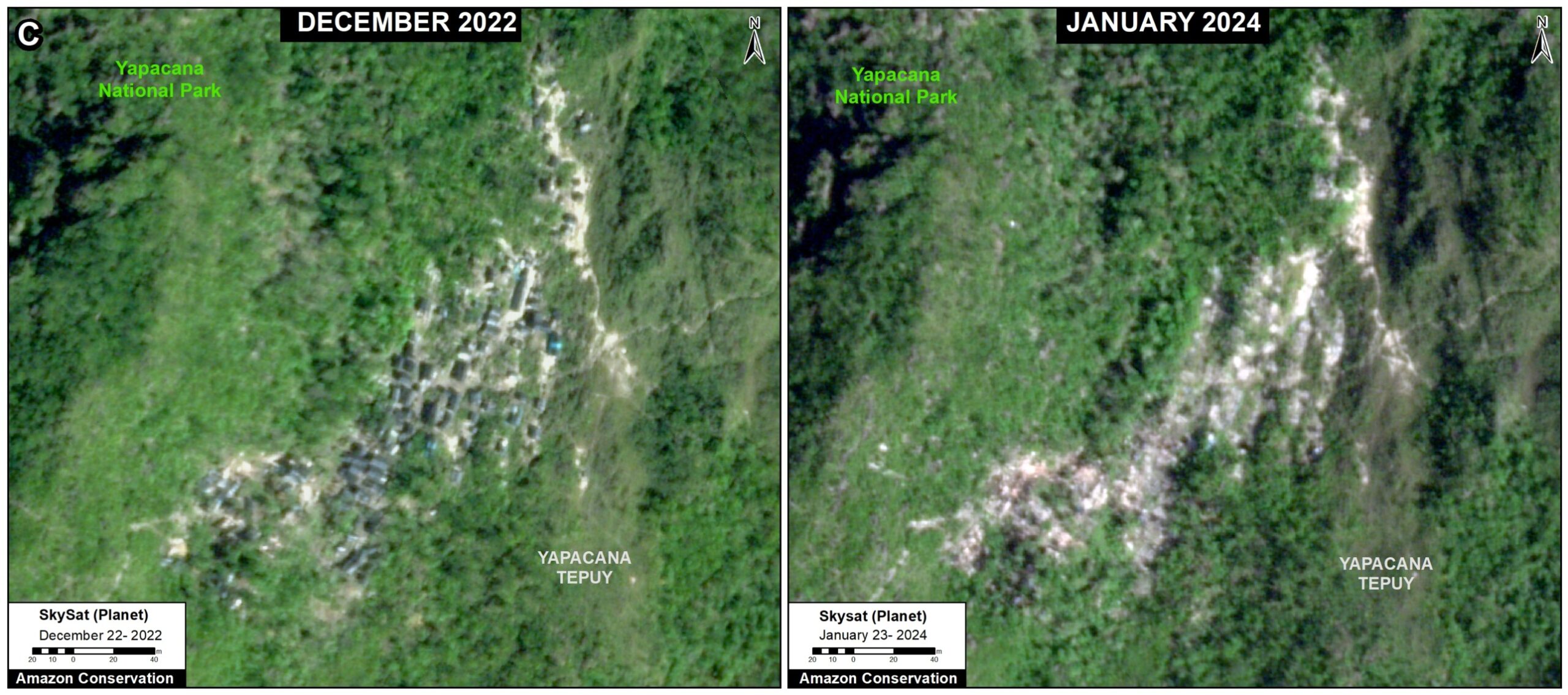
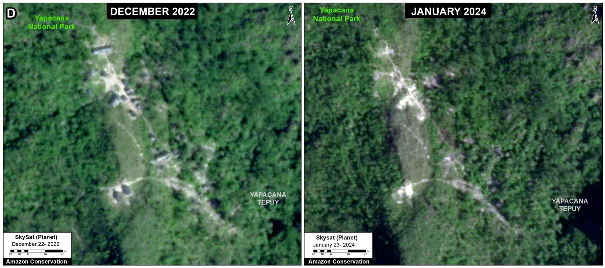
Here, we show a series of very high-resolution satellite images taken during the raid (December 2022) versus one year later (January 2024).

The images reveal that all illegal mining camps and equipment on top of the tepui have been effectively dismantled. That is, we went from 425 visible illegal mining camps and heavy equipment in December 2022 to zero in January 2024.

This removal of illegal mining activity from the tepui marks an important victory for Amazon conservation in Venezuela. However, as also detailed below, we show illegal mining continues in surrounding areas within and outside the Yapacana National Park.

Illegal Mining on the Tepui
Before vs After the Government Operation

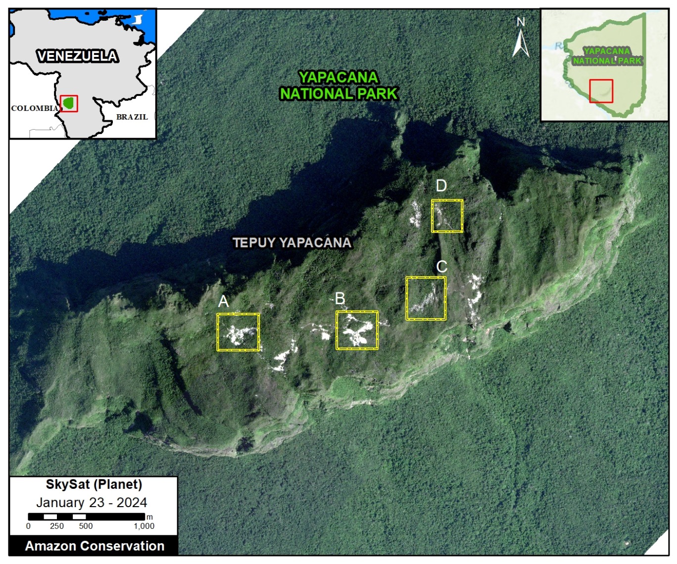
The Figure 1 (see below) shows an aerial view of the tepui as of December 2022, surrounded by the lowland rainforest of Yapacana National. The white indicates the illegal mining activity occurring on the tepui and in the park (not including the whispy clouds passing the tepui).

Insets A-D indicate the locations of the four zooms, where we show a series of very high-resolution satellite images taken during the raid (December 2022) versus one year later (January 2024). Note that in each image, there is clear evidence of mining camps in December 2022 (left image) vs. no remaining mining camps in January 2024 (right image).

Figure 1. Former active mining sites on top of tepui in Yapacana National Park. Data: Planet/Skysat, ACA/MAAP.

Yapacana Tepui, Zoom A.

Yapacana Tepui, Zoom B.

Yapacana Tepui, Zoom C.

Yapacana Tepui, Zoom D.

Mining Continues in Yapacana National Park

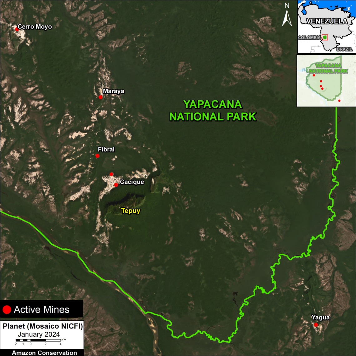
Figure 2. Active mines in and around Yapacana National Park. Data: Planet/NICFI, ACA/MAAP.

While above we credit the Venezuelan government for removing illegal mining activity from the top of the tepui, in this section we note that illegal mining is still occurring in multiple sites within and around Yapacana National Park (see Figure 2).

Below we show a series of satellite images of illegal mining camps and equipment in several of these continuing active sites: Cacique, Cerro Moyo, and Yagua.

Cacique

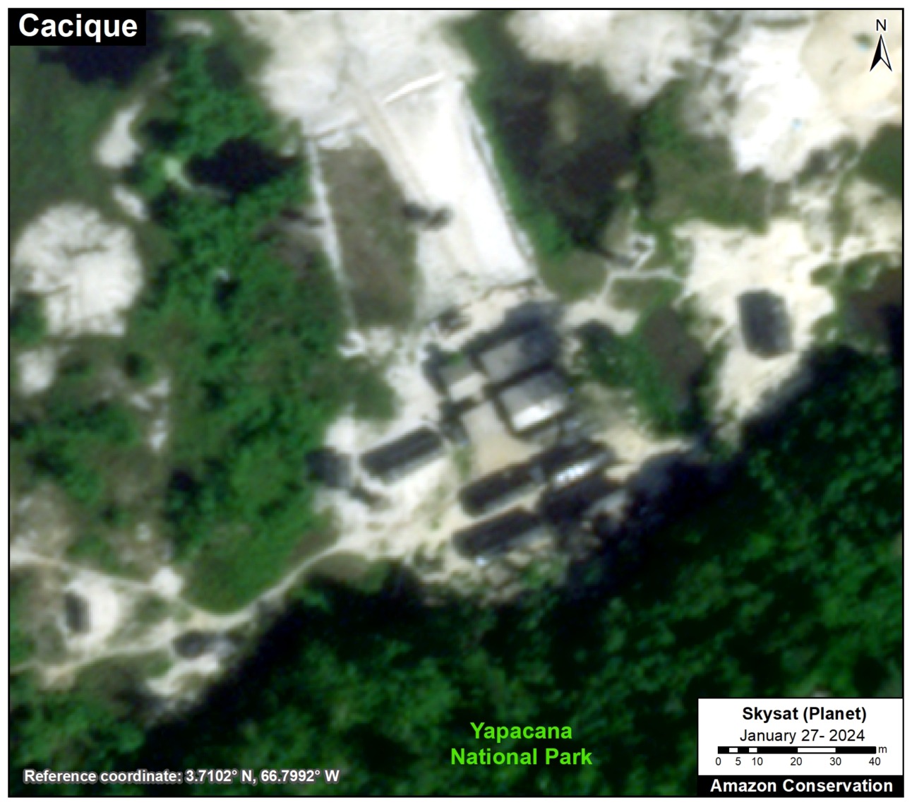
The Cacique site, located in the southern sector of Yapacana National Park close to the tepui, we recently observed what appears to be a cluster mining camps.

Figure 3. Zoom of Cacique mining site, within Yapacana National Park. Data: Planet/Skysat, ACA/MAAP.

Cerro Moyo

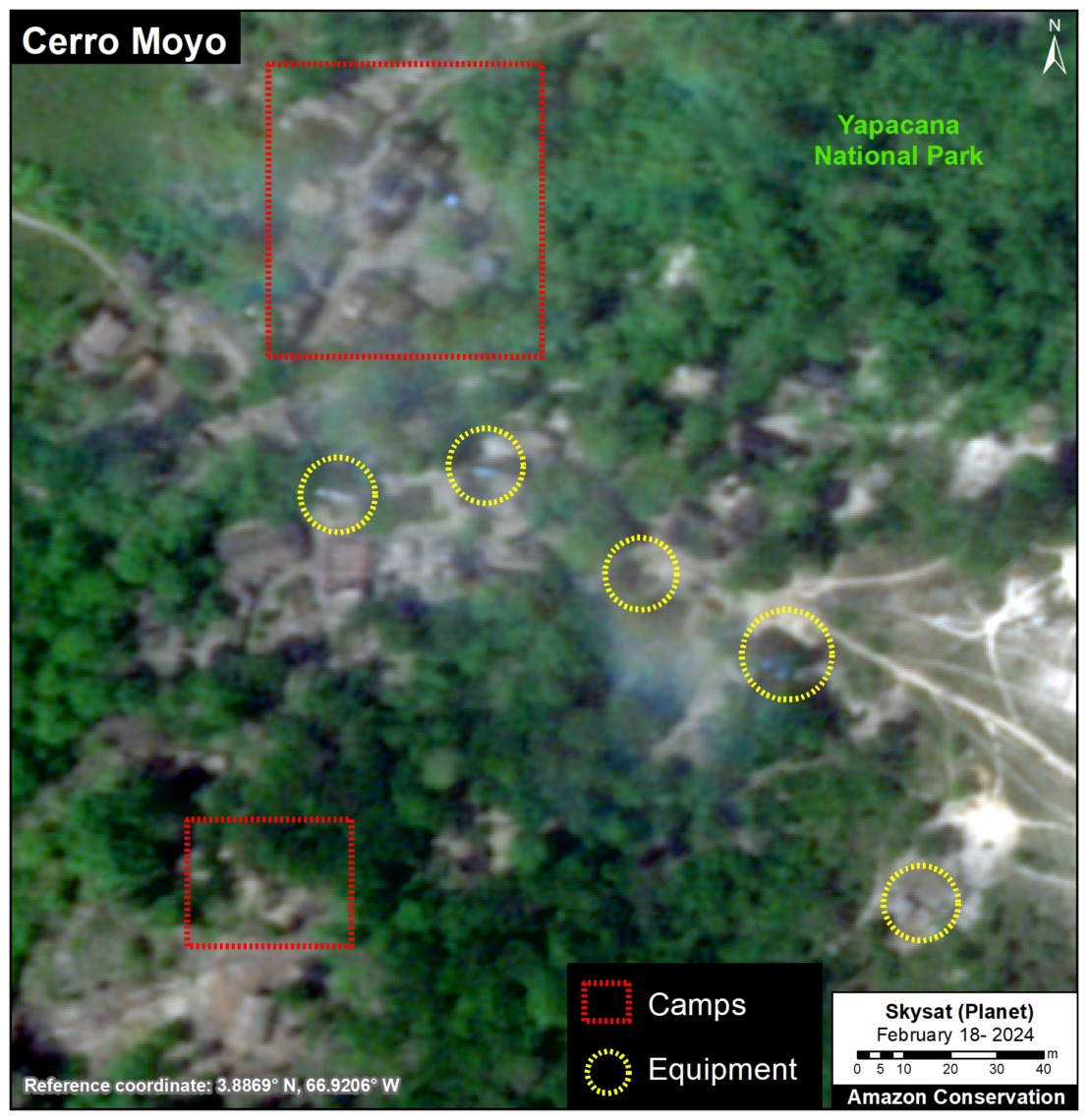
At the Cerro Moyo site, located in the northwest sector of Yapacana National Park, we see both mining camps and equipment.

Figure 4. Zoom of Cerro Moyo mining site, within Yapacana National Park. Data: Planet/Skysat, ACA/MAAP.

Yagua

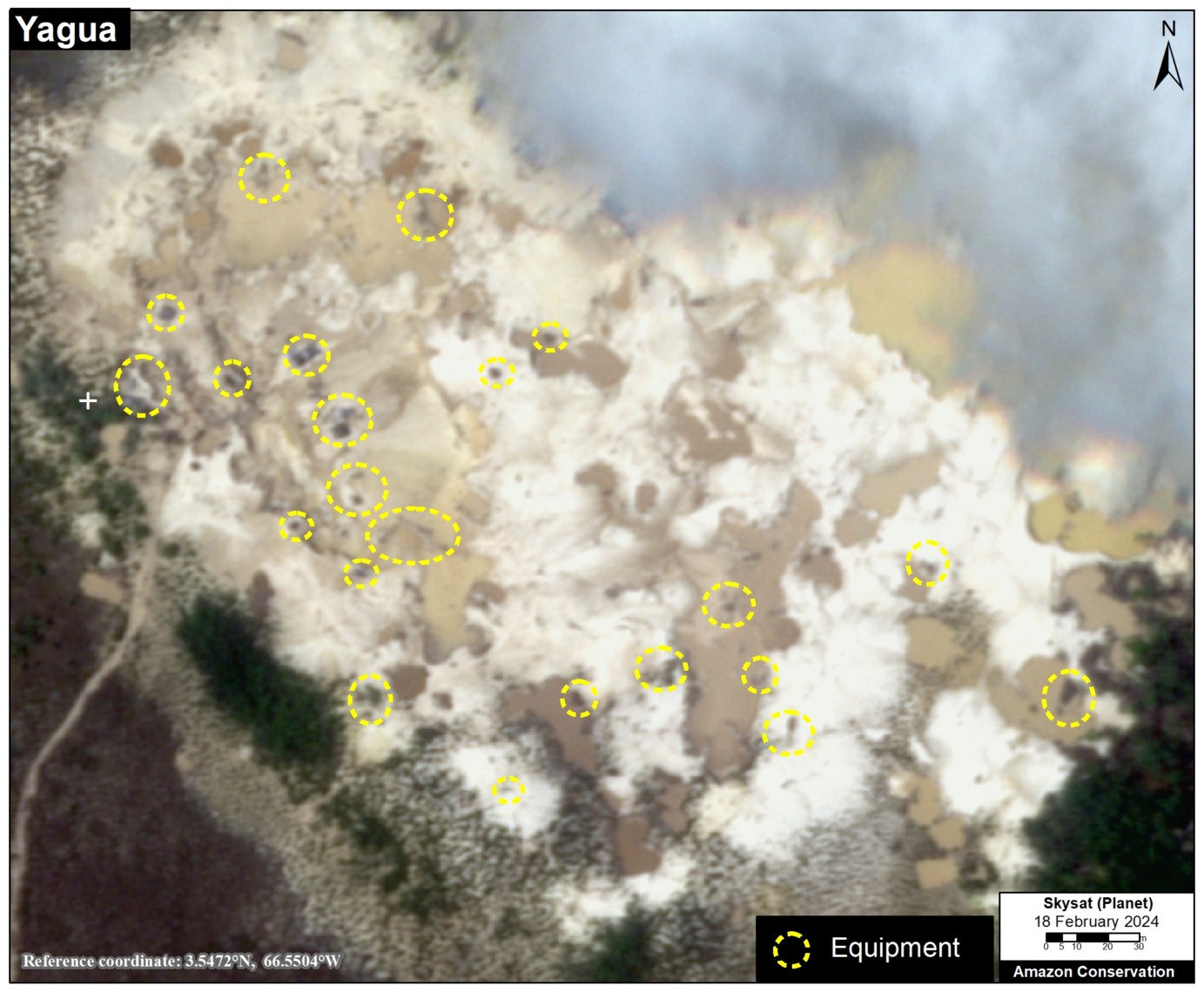
Note the Yagua site is located just outside the southeast sector of Yapacana National Park, but is also illegal (all mining within Amazonas province is prohibited by law). At this site we see abundant mining equipment.

Figure 5. Zoom of Yagua mining site, outside of Yapacana National Park. Data: Planet/Skysat, ACA/MAAP.

Reconhecimentos

We thank the organization  SOSOrinoco for important information and comments related to this report.

Citação

Finer M, Ariñez A (2024) Dismantling Illegal Mining from Sacred Tepui (Venezuelan Amazon). MAAP: 207.